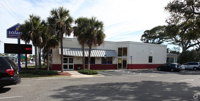
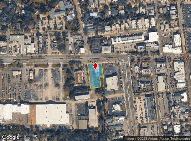
Property Record
410 Atlantic Blvd, Neptune Beach, FL 32266

NEARBY LISTINGS FOR SALE OR LEASE
Property Detail
410 Atlantic Blvd
Jacksonville, FL
Hornes Neptune Acres Pt
172913-0100
13-87 21-2S-29E .81 HORNES NEPTUNE ACRES PT UNNUMBERED ACRE PARCEL, PT GOVT LOT 1 RECD O/R 16012-263
Medicalbuilding
Duval
X
Florida
12031C0409J
1
2024
0.81 AC
2025
Beaches
014001
Jacksonville (Florida)
4,688 SF
DEMOGRAPHICS near 410 Atlantic Blvd
1 Mile
3 Mile
5 Mile
2024 Total Population
9,354
46,651
107,941
2029 Population
9,786
49,051
113,177
Pop Growth 2024-2029
+ 4.62%
+ 5.14%
+ 4.85%
Average Age
43
43
41
2024 Total Households
4,311
21,236
45,342
HH Growth 2024-2029
+ 4.92%
+ 5.41%
+ 5.09%
Median Household Inc
$103,170
$90,402
$90,947
Avg Household Size
2.20
2.20
2.30
2024 Avg HH Vehicles
2.00
2.00
2.00
Median Home Value
$490,035
$428,276
$391,074
Median Year Built
1974
1983
1990
Nearby Places
Map Layers
Map Styles
 Street
 Aerial
- Restaurants
- Banks
- Shops
- Fitness
- Groceries
PUBLIC TRANSPORTATION
AIRPORT
Jacksonville International
DRIVE
WALK
Distance
Jacksonville International
40 min
25.6 mi
Freight Ports
Jacksonville Port
DRIVE
WALK
Distance
Jacksonville Port
31 min
17.3 mi
Nearby Properties
Address
Land Use
TOTAL SIZE
Lot Size
Zoning
Address
Land Use
TOTAL SIZE
Lot Size
Zoning
240,363 SF
24.71 AC
PUD
Address
Land Use
TOTAL SIZE
Lot Size
Zoning
377,617 SF
23.38 AC
PUD
Address
Land Use
TOTAL SIZE
Lot Size
Zoning
178,884 SF
12.54 AC
PUD
Address
Land Use
TOTAL SIZE
Lot Size
Zoning
194,953 SF
22.43 AC
PUD
Address
Land Use
TOTAL SIZE
Lot Size
Zoning
696,126 SF
70.05 AC
APUD
Address
Land Use
TOTAL SIZE
Lot Size
Zoning
235,939 SF
11.25 AC
JRM-1
Address
Land Use
TOTAL SIZE
Lot Size
Zoning
34,612 SF
446.76 AC
PBF-1
Address
Land Use
TOTAL SIZE
Lot Size
Zoning
115,119 SF
1.14 AC
JRD
Address
Land Use
TOTAL SIZE
Lot Size
Zoning
50,124 SF
2.53 AC
JRM-2
Address
Land Use
TOTAL SIZE
Lot Size
Zoning
90,729 SF
0.99 AC
JRD
Address
Land Use
TOTAL SIZE
Lot Size
Zoning
65,384 SF
2.33 AC
ACG
Address
Land Use
TOTAL SIZE
Lot Size
Zoning
44,526 SF
1.98 AC
JRM-2
Address
Land Use
TOTAL SIZE
Lot Size
Zoning
265,386 SF
29.35 AC
RMD-C
Address
Land Use
TOTAL SIZE
Lot Size
Zoning
206,990 SF
15.76 AC
RMD-D
Address
Land Use
TOTAL SIZE
Lot Size
Zoning
244,454 SF
14.76 AC
NR-5
Address
Land Use
TOTAL SIZE
Lot Size
Zoning
185,402 SF
14.03 AC
RMD-C
Address
Land Use
TOTAL SIZE
Lot Size
Zoning
157,942 SF
15.55 AC
PUD
Address
Land Use
TOTAL SIZE
Lot Size
Zoning
171,440 SF
11.15 AC
PUD
Address
Land Use
TOTAL SIZE
Lot Size
Zoning
219,659 SF
21.37 AC
NR-1
Address
Land Use
TOTAL SIZE
Lot Size
Zoning
26,510 SF
1.36 AC
JCBD
Address
Land Use
TOTAL SIZE
Lot Size
Zoning
120,233 SF
14.08 AC
ACG
Address
Land Use
TOTAL SIZE
Lot Size
Zoning
167,476 SF
12.89 AC
RMD-C
Address
Land Use
TOTAL SIZE
Lot Size
Zoning
248,601 SF
43.01 AC
PBF-1
Address
Land Use
TOTAL SIZE
Lot Size
Zoning
122,836 SF
26.31 AC
JPUD
Address
Land Use
TOTAL SIZE
Lot Size
Zoning
136,558 SF
1.89 AC
JC-2
Address
Land Use
TOTAL SIZE
Lot Size
Zoning
74,004 SF
26.19 AC
JI-1
Address
Land Use
TOTAL SIZE
Lot Size
Zoning
95,879 SF
14.46 AC
PUD
Address
Land Use
TOTAL SIZE
Lot Size
Zoning
104,220 SF
7.80 AC
JI-1
Address
Land Use
TOTAL SIZE
Lot Size
Zoning
17.79 AC
JRS-1
Address
Land Use
TOTAL SIZE
Lot Size
Zoning
110,902 SF
8.15 AC
RMD-C
The World's #1 Commercial Real Estate Marketplace
Connect with us
© 2025 CoStar Group
The information above has been obtained from sources believed reliable. While we do not doubt its accuracy we have not verified it and make no guarantee, warranty or representation about it. It is your responsibility to independently confirm its accuracy and completeness. Any projections, opinions, assumptions, or estimates used are for example only and do not represent the current or future performance of the property. The value of this transaction to you depends on tax and other factors which should be evaluated by your tax, financial, and legal advisors. You and your advisors should conduct a careful, independent investigation of the property to determine to your satisfaction the suitability of the property for your needs.