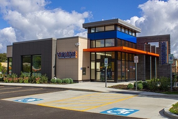
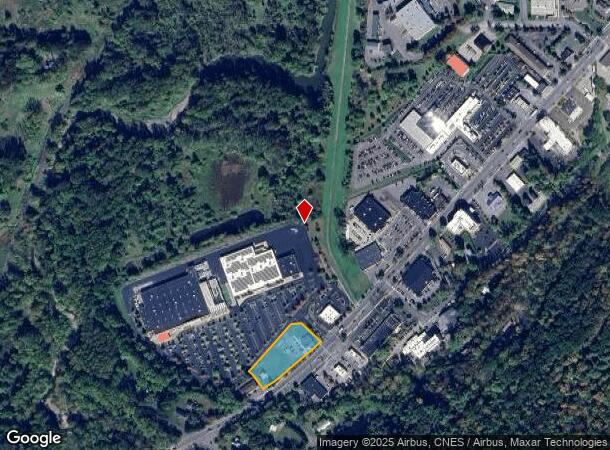
Property Record
410 Elmira Rd, Ithaca, NY 14850
NEARBY LISTINGS FOR SALE OR LEASE
Property Detail
410 Elmira Rd
500700-131-000-0001-006-003-0000
Tompkins
Financialbuilding
New York
X
6.003
36109C0192D
1.59 AC
2025
Ithaca
2024
Other Market Areas
001000
Ithaca, NY
3,320 SF
DEMOGRAPHICS near 410 Elmira Rd
1 Mile
3 Mile
5 Mile
2024 Total Population
950
36,013
59,568
2029 Population
814
31,286
52,138
Pop Growth 2024-2029
(14.32%)
(13.13%)
(12.47%)
Average Age
39
34
35
2024 Total Households
431
13,867
21,979
HH Growth 2024-2029
(16.47%)
(16.95%)
(16.47%)
Median Household Inc
$49,127
$47,017
$60,836
Avg Household Size
2.10
2.00
2.00
2024 Avg HH Vehicles
1.00
1.00
1.00
Median Home Value
$246,551
$307,308
$316,900
Median Year Built
1968
1967
1971
Nearby Places
Map Layers
Map Styles
 Street
 Aerial
- Restaurants
- Banks
- Shops
- Fitness
- Groceries
PUBLIC TRANSPORTATION
AIRPORT
Ithaca Tompkins International
DRIVE
WALK
Distance
Ithaca Tompkins International
15 min
7.2 mi
Elmira/Corning Regional
DRIVE
WALK
Distance
Elmira/Corning Regional
42 min
32.6 mi
Freight Ports
Albany, NY Port
DRIVE
WALK
Distance
Albany, NY Port
224 min
168.1 mi
SALE & LEASE HISTORY
LISTING DATE
SALE/LEASE

Dec 19, 2018
For Lease
Nearby Properties
Address
Land Use
TOTAL SIZE
Lot Size
Zoning
Address
Land Use
TOTAL SIZE
Lot Size
Zoning
5,000 SF
154.28 AC
U-1
Address
Land Use
TOTAL SIZE
Lot Size
Zoning
2,212,226 SF
588.22 AC
Address
Land Use
TOTAL SIZE
Lot Size
Zoning
338,706 SF
2.08 AC
U-1
Address
Land Use
TOTAL SIZE
Lot Size
Zoning
276,302 SF
15.94 AC
Address
Land Use
TOTAL SIZE
Lot Size
Zoning
1.30 AC
U-1
Address
Land Use
TOTAL SIZE
Lot Size
Zoning
50,319 SF
25.92 AC
Address
Land Use
TOTAL SIZE
Lot Size
Zoning
19,600 SF
22.51 AC
P-1
Address
Land Use
TOTAL SIZE
Lot Size
Zoning
218,211 SF
0.76 AC
CBD-60
Address
Land Use
TOTAL SIZE
Lot Size
Zoning
4,400 SF
30.50 AC
Address
Land Use
TOTAL SIZE
Lot Size
Zoning
150,015 SF
4.94 AC
U-1
Address
Land Use
TOTAL SIZE
Lot Size
Zoning
199,578 SF
0.56 AC
CBD-60
Address
Land Use
TOTAL SIZE
Lot Size
Zoning
131,532 SF
2.20 AC
U-1
Address
Land Use
TOTAL SIZE
Lot Size
Zoning
8,100 SF
0.51 AC
CBD-60
Address
Land Use
TOTAL SIZE
Lot Size
Zoning
115,796 SF
26.51 AC
Address
Land Use
TOTAL SIZE
Lot Size
Zoning
0.93 AC
U-1
Address
Land Use
TOTAL SIZE
Lot Size
Zoning
228,978 SF
4.96 AC
Address
Land Use
TOTAL SIZE
Lot Size
Zoning
112,392 SF
0.76 AC
B-2B
Address
Land Use
TOTAL SIZE
Lot Size
Zoning
185,997 SF
0.17 AC
CBD-140
Address
Land Use
TOTAL SIZE
Lot Size
Zoning
26,658 SF
0.69 AC
R-3A
Address
Land Use
TOTAL SIZE
Lot Size
Zoning
5,555 SF
12.07 AC
P-1
Address
Land Use
TOTAL SIZE
Lot Size
Zoning
86,700 SF
0.86 AC
B-1A
Address
Land Use
TOTAL SIZE
Lot Size
Zoning
114,085 SF
0.77 AC
B-2C
Address
Land Use
TOTAL SIZE
Lot Size
Zoning
24,673 SF
0.38 AC
B-2B
Address
Land Use
TOTAL SIZE
Lot Size
Zoning
75,861 SF
0.97 AC
B-2B
Address
Land Use
TOTAL SIZE
Lot Size
Zoning
171,299 SF
3.59 AC
Address
Land Use
TOTAL SIZE
Lot Size
Zoning
43,592 SF
1.71 AC
P-1
Address
Land Use
TOTAL SIZE
Lot Size
Zoning
125,988 SF
0.61 AC
CBD-60
Address
Land Use
TOTAL SIZE
Lot Size
Zoning
64,708 SF
1.13 AC
B-2C
Address
Land Use
TOTAL SIZE
Lot Size
Zoning
7,434 SF
1.25 AC
P-1
The World's #1 Commercial Real Estate Marketplace
Connect with us
© 2025 CoStar Group
The information above has been obtained from sources believed reliable. While we do not doubt its accuracy we have not verified it and make no guarantee, warranty or representation about it. It is your responsibility to independently confirm its accuracy and completeness. Any projections, opinions, assumptions, or estimates used are for example only and do not represent the current or future performance of the property. The value of this transaction to you depends on tax and other factors which should be evaluated by your tax, financial, and legal advisors. You and your advisors should conduct a careful, independent investigation of the property to determine to your satisfaction the suitability of the property for your needs.