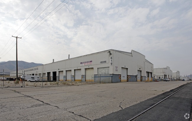
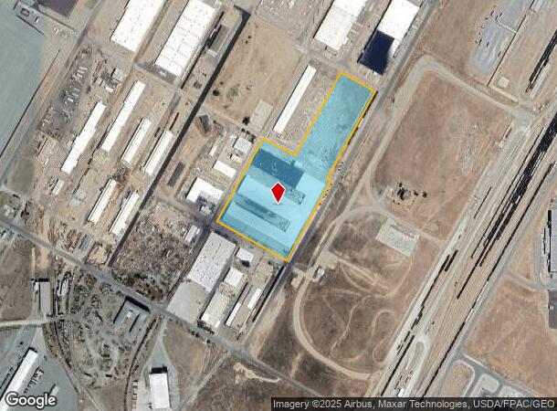
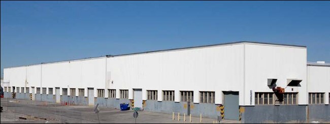
Property Record
410 Garnet St, Tooele, UT 84074
NEARBY LISTINGS FOR SALE OR LEASE
Property Detail
410 Garnet St
Salt Lake City, UT
Minor Subdivision
19-011-0-0101
LOT 101, BUILDING 619 MINOR SUBDIVISION AMENDED, A SUBDIVISION OF TOOELE CITY. OUT OF 18-55-1 FOR 2016 YEAR. 11.079 AC
Industrialgeneral
Tooele
D
Utah
49045C1640C
101
2025
11.08 AC
2025
Tooele County
130900
Salt Lake City
191,148 SF
DEMOGRAPHICS near 410 Garnet St
1 Mile
3 Mile
5 Mile
2024 Total Population
8
19,608
42,153
2029 Population
10
24,473
52,740
Pop Growth 2024-2029
+ 25.00%
+ 24.81%
+ 25.12%
Average Age
25
34
34
2024 Total Households
2
6,611
13,536
HH Growth 2024-2029
+ 50.00%
+ 25.23%
+ 25.51%
Median Household Inc
$87,500
$79,980
$86,960
Avg Household Size
2.00
2.90
3.10
2024 Avg HH Vehicles
2.00
2.00
3.00
Median Home Value
$399,999
$274,031
$292,017
Median Year Built
2010
1991
1995
Nearby Places
Map Layers
Map Styles
 Street
 Aerial
- Restaurants
- Banks
- Shops
- Fitness
- Groceries
PUBLIC TRANSPORTATION
AIRPORT
Salt Lake City International
DRIVE
WALK
Distance
Salt Lake City International
46 min
33.4 mi
SALE & LEASE HISTORY
LISTING DATE
SALE/LEASE

May 08, 2017
For Lease
Nearby Properties
Address
Land Use
TOTAL SIZE
Lot Size
Zoning
Address
Land Use
TOTAL SIZE
Lot Size
Zoning
205,900 SF
107.47 AC
Address
Land Use
TOTAL SIZE
Lot Size
Zoning
8.47 AC
Address
Land Use
TOTAL SIZE
Lot Size
Zoning
610,536 SF
48.93 AC
Address
Land Use
TOTAL SIZE
Lot Size
Zoning
263,948 SF
47.90 AC
Address
Land Use
TOTAL SIZE
Lot Size
Zoning
8.32 AC
Address
Land Use
TOTAL SIZE
Lot Size
Zoning
999,999 SF
10.51 AC
Address
Land Use
TOTAL SIZE
Lot Size
Zoning
339,571 SF
35.61 AC
Address
Land Use
TOTAL SIZE
Lot Size
Zoning
90,340 SF
41.76 AC
Address
Land Use
TOTAL SIZE
Lot Size
Zoning
14,400 SF
5.48 AC
Address
Land Use
TOTAL SIZE
Lot Size
Zoning
54,648 SF
4.53 AC
Address
Land Use
TOTAL SIZE
Lot Size
Zoning
140,412 SF
10.38 AC
Address
Land Use
TOTAL SIZE
Lot Size
Zoning
3.50 AC
Address
Land Use
TOTAL SIZE
Lot Size
Zoning
114,155 SF
20 AC
Address
Land Use
TOTAL SIZE
Lot Size
Zoning
59,960 SF
16.45 AC
Address
Land Use
TOTAL SIZE
Lot Size
Zoning
60,127 SF
1.67 AC
Address
Land Use
TOTAL SIZE
Lot Size
Zoning
53,151 SF
1.18 AC
Address
Land Use
TOTAL SIZE
Lot Size
Zoning
1,532 SF
40.33 AC
Address
Land Use
TOTAL SIZE
Lot Size
Zoning
2,540 SF
2.25 AC
Address
Land Use
TOTAL SIZE
Lot Size
Zoning
24,550 SF
0.86 AC
Address
Land Use
TOTAL SIZE
Lot Size
Zoning
60,169 SF
40.57 AC
Address
Land Use
TOTAL SIZE
Lot Size
Zoning
59,652 SF
2.37 AC
Address
Land Use
TOTAL SIZE
Lot Size
Zoning
37,261 SF
3.03 AC
Address
Land Use
TOTAL SIZE
Lot Size
Zoning
52,141 SF
5 AC
Address
Land Use
TOTAL SIZE
Lot Size
Zoning
141,845 SF
8.58 AC
Address
Land Use
TOTAL SIZE
Lot Size
Zoning
42,250 SF
3 AC
Address
Land Use
TOTAL SIZE
Lot Size
Zoning
32,427 SF
0.73 AC
The World's #1 Commercial Real Estate Marketplace
Connect with us
© 2026 CoStar Group
The information above has been obtained from sources believed reliable. While we do not doubt its accuracy we have not verified it and make no guarantee, warranty or representation about it. It is your responsibility to independently confirm its accuracy and completeness. Any projections, opinions, assumptions, or estimates used are for example only and do not represent the current or future performance of the property. The value of this transaction to you depends on tax and other factors which should be evaluated by your tax, financial, and legal advisors. You and your advisors should conduct a careful, independent investigation of the property to determine to your satisfaction the suitability of the property for your needs.