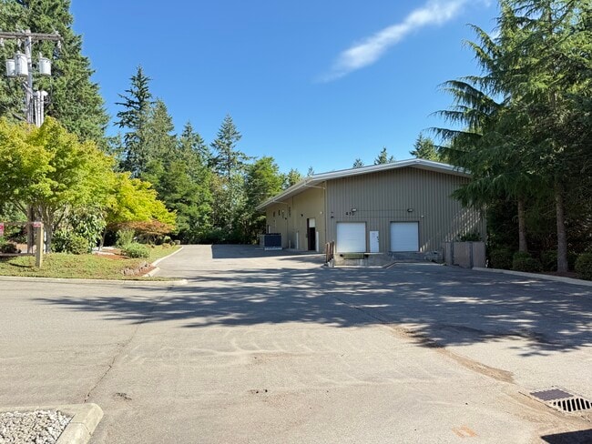
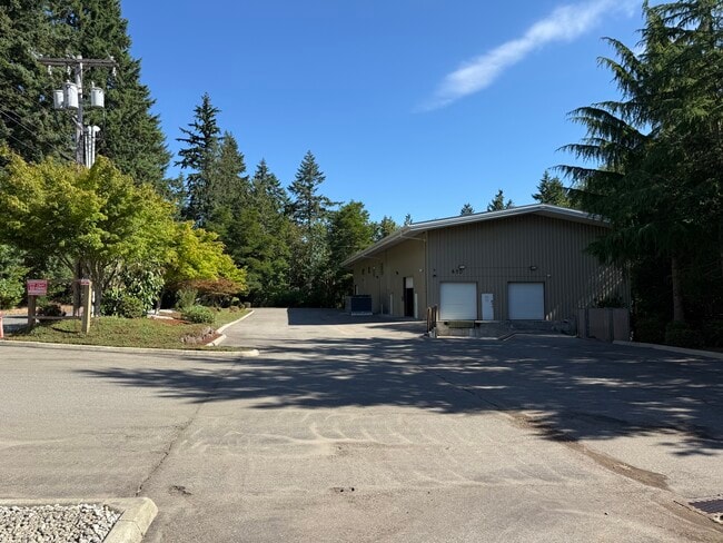
Property Record
410 Ida St W, Bremerton, WA 98312

Current Lease Availabilities
NEARBY LISTINGS FOR SALE OR LEASE
Property Detail
410 Ida St W
Bremerton-Silverdale-Port Orchard, WA
Rainier Tracts
4627-002-019-00-00
LOTS 19 TO 24, BLOCK 2, RAINIER TRACTS, AS RECORDED IN VOLUME 6 OF PLATS, PAGE 51, RECORDS OF KITSAP COUNTY, WASHINGTON.
Warehouse
Kitsap
X
Washington
53035C0365F
19-24
2025
0.93 AC
2026
West Bremerton
080900
Bremerton/Silverdale
7,700 SF
DEMOGRAPHICS near 410 Ida St W
1 Mile
3 Mile
5 Mile
2024 Total Population
4,399
39,395
103,161
2029 Population
4,645
40,395
106,123
Pop Growth 2024-2029
+ 5.59%
+ 2.54%
+ 2.87%
Average Age
41
38
40
2024 Total Households
1,939
14,432
39,614
HH Growth 2024-2029
+ 5.78%
+ 2.92%
+ 3.09%
Median Household Inc
$48,749
$80,518
$81,227
Avg Household Size
2.20
2.30
2.40
2024 Avg HH Vehicles
2.00
2.00
2.00
Median Home Value
$423,077
$450,088
$468,441
Median Year Built
1995
1967
1978
Nearby Places
Map Layers
Map Styles
 Street
 Aerial
- Restaurants
- Banks
- Shops
- Fitness
- Groceries
PUBLIC TRANSPORTATION
AIRPORT
Seattle Paine Field International
DRIVE
WALK
Distance
Seattle Paine Field International
109 min
43.9 mi
Freight Ports
Port of Seattle
DRIVE
WALK
Distance
Port of Seattle
74 min
25.0 mi
Nearby Properties
Address
Land Use
TOTAL SIZE
Lot Size
Zoning
Address
Land Use
TOTAL SIZE
Lot Size
Zoning
21,408 SF
8.26 AC
BVSAP
Address
Land Use
TOTAL SIZE
Lot Size
Zoning
138,877 SF
7.17 AC
R-10
Address
Land Use
TOTAL SIZE
Lot Size
Zoning
66,022 SF
8.28 AC
RR
Address
Land Use
TOTAL SIZE
Lot Size
Zoning
112,847 SF
6.80 AC
UM
Address
Land Use
TOTAL SIZE
Lot Size
Zoning
Address
Land Use
TOTAL SIZE
Lot Size
Zoning
75,390 SF
4.46 AC
R-18
Address
Land Use
TOTAL SIZE
Lot Size
Zoning
68,079 SF
2.16 AC
BVSAP
Address
Land Use
TOTAL SIZE
Lot Size
Zoning
73,931 SF
11.72 AC
FC
Address
Land Use
TOTAL SIZE
Lot Size
Zoning
43,944 SF
2.64 AC
FC
Address
Land Use
TOTAL SIZE
Lot Size
Zoning
45,682 SF
2.04 AC
GC
Address
Land Use
TOTAL SIZE
Lot Size
Zoning
75,225 SF
3.30 AC
R-10
Address
Land Use
TOTAL SIZE
Lot Size
Zoning
55,866 SF
8.48 AC
FC
Address
Land Use
TOTAL SIZE
Lot Size
Zoning
48,520 SF
3.76 AC
GC
Address
Land Use
TOTAL SIZE
Lot Size
Zoning
44,220 SF
2.86 AC
R-40
Address
Land Use
TOTAL SIZE
Lot Size
Zoning
52,461 SF
5.92 AC
RR
Address
Land Use
TOTAL SIZE
Lot Size
Zoning
42,665 SF
5.55 AC
FC
Address
Land Use
TOTAL SIZE
Lot Size
Zoning
51,933 SF
4.07 AC
C
Address
Land Use
TOTAL SIZE
Lot Size
Zoning
75,000 SF
3.61 AC
LI
Address
Land Use
TOTAL SIZE
Lot Size
Zoning
52,601 SF
6.30 AC
BVSAP
Address
Land Use
TOTAL SIZE
Lot Size
Zoning
47,064 SF
5.27 AC
GC
Address
Land Use
TOTAL SIZE
Lot Size
Zoning
48,130 SF
0.42 AC
DSAP
Address
Land Use
TOTAL SIZE
Lot Size
Zoning
29,079 SF
9.95 AC
PF
Address
Land Use
TOTAL SIZE
Lot Size
Zoning
74,169 SF
2.62 AC
GC
Address
Land Use
TOTAL SIZE
Lot Size
Zoning
34,792 SF
1.89 AC
R-10
Address
Land Use
TOTAL SIZE
Lot Size
Zoning
31,164 SF
0.55 AC
DSAP
Address
Land Use
TOTAL SIZE
Lot Size
Zoning
46,395 SF
2.41 AC
FC
Address
Land Use
TOTAL SIZE
Lot Size
Zoning
24,376 SF
0.87 AC
INST
Address
Land Use
TOTAL SIZE
Lot Size
Zoning
28,982 SF
1.90 AC
GC
Address
Land Use
TOTAL SIZE
Lot Size
Zoning
1,508 SF
1.84 AC
R-10
Address
Land Use
TOTAL SIZE
Lot Size
Zoning
40,131 SF
4.90 AC
FC
The World's #1 Commercial Real Estate Marketplace
Connect with us
© 2026 CoStar Group
The information above has been obtained from sources believed reliable. While we do not doubt its accuracy we have not verified it and make no guarantee, warranty or representation about it. It is your responsibility to independently confirm its accuracy and completeness. Any projections, opinions, assumptions, or estimates used are for example only and do not represent the current or future performance of the property. The value of this transaction to you depends on tax and other factors which should be evaluated by your tax, financial, and legal advisors. You and your advisors should conduct a careful, independent investigation of the property to determine to your satisfaction the suitability of the property for your needs.