Property Record
410 Mohawk Dr, Fonda, NY 12068


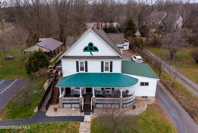
This Property Is For Sale
NEARBY LISTINGS FOR SALE OR LEASE
-
-
View all Fonda listings for sale on LoopNet.com
Property Detail
410 Mohawk Dr
273289-037-014-0001-019-000-0000
Montgomery
Bartavern
New York
X
19.000
36057C0183E
0.78 AC
2025
Montgomery County
2024
Albany/Schenectady/Troy
072200
Amsterdam, NY
2,116 SF
DEMOGRAPHICS near 410 Mohawk Dr
1 Mile
3 Mile
5 Mile
2024 Total Population
1,001
2,333
11,126
2029 Population
981
2,304
10,988
Pop Growth 2024-2029
(2.00%)
(1.24%)
(1.24%)
Average Age
46
44
43
2024 Total Households
443
945
4,392
HH Growth 2024-2029
(2.26%)
(1.38%)
(1.16%)
Median Household Inc
$79,563
$77,641
$65,714
Avg Household Size
2.20
2.40
2.30
2024 Avg HH Vehicles
2.00
2.00
2.00
Median Home Value
$149,807
$150,116
$153,857
Median Year Built
1950
1949
1948
Nearby Places
Map Layers
Map Styles
 Street
 Aerial
- Restaurants
- Banks
- Shops
- Fitness
- Groceries
PUBLIC TRANSPORTATION
COMMUTER RAIL
Amsterdam (Toronto - New York - VIA Rail)
DRIVE
WALK
Distance
Amsterdam (Toronto - New York - VIA Rail)
7 min
4.4 mi
Amsterdam Amtrak Station (Empire Service - Amtrak, Maple Leaf - Amtrak)
DRIVE
WALK
Distance
Amsterdam Amtrak Station (Empire Service - Amtrak, Maple Leaf - Amtrak)
7 min
4.4 mi
AIRPORT
Albany International
DRIVE
WALK
Distance
Albany International
53 min
34.2 mi
Freight Ports
Albany, NY Port
DRIVE
WALK
Distance
Albany, NY Port
54 min
40.9 mi
Nearby Properties
Address
Land Use
TOTAL SIZE
Lot Size
Zoning
Address
Land Use
TOTAL SIZE
Lot Size
Zoning
8,825 SF
80.10 AC
CONF
Address
Land Use
TOTAL SIZE
Lot Size
Zoning
8,924 SF
241.40 AC
Address
Land Use
TOTAL SIZE
Lot Size
Zoning
756,760 SF
102.40 AC
Address
Land Use
TOTAL SIZE
Lot Size
Zoning
158,480 SF
35.79 AC
Address
Land Use
TOTAL SIZE
Lot Size
Zoning
126,707 SF
39.10 AC
Address
Land Use
TOTAL SIZE
Lot Size
Zoning
6.90 AC
Address
Land Use
TOTAL SIZE
Lot Size
Zoning
69,900 SF
24 AC
Address
Land Use
TOTAL SIZE
Lot Size
Zoning
97,304 SF
41.90 AC
Address
Land Use
TOTAL SIZE
Lot Size
Zoning
22,045 SF
17.89 AC
B2
Address
Land Use
TOTAL SIZE
Lot Size
Zoning
34,802 SF
4.10 AC
Address
Land Use
TOTAL SIZE
Lot Size
Zoning
101,736 SF
92.40 AC
Address
Land Use
TOTAL SIZE
Lot Size
Zoning
383.63 AC
CONF
Address
Land Use
TOTAL SIZE
Lot Size
Zoning
106.70 AC
M1
Address
Land Use
TOTAL SIZE
Lot Size
Zoning
32.20 AC
R2
Address
Land Use
TOTAL SIZE
Lot Size
Zoning
54,000 SF
0.10 AC
Address
Land Use
TOTAL SIZE
Lot Size
Zoning
Address
Land Use
TOTAL SIZE
Lot Size
Zoning
17,088 SF
4.50 AC
RA
Address
Land Use
TOTAL SIZE
Lot Size
Zoning
133,090 SF
18.70 AC
B2
Address
Land Use
TOTAL SIZE
Lot Size
Zoning
4,200 SF
19.70 AC
B2
Address
Land Use
TOTAL SIZE
Lot Size
Zoning
8,000 SF
6.40 AC
Address
Land Use
TOTAL SIZE
Lot Size
Zoning
15,728 SF
66.70 AC
Address
Land Use
TOTAL SIZE
Lot Size
Zoning
12,755 SF
10.50 AC
Address
Land Use
TOTAL SIZE
Lot Size
Zoning
35,808 SF
76 AC
Address
Land Use
TOTAL SIZE
Lot Size
Zoning
3,608 SF
266.90 AC
Address
Land Use
TOTAL SIZE
Lot Size
Zoning
13,680 SF
5.40 AC
Address
Land Use
TOTAL SIZE
Lot Size
Zoning
980 SF
21.70 AC
CONF
Address
Land Use
TOTAL SIZE
Lot Size
Zoning
17,528 SF
10.50 AC
Address
Land Use
TOTAL SIZE
Lot Size
Zoning
16,000 SF
5.10 AC
B2
Address
Land Use
TOTAL SIZE
Lot Size
Zoning
10,000 SF
7.90 AC
Address
Land Use
TOTAL SIZE
Lot Size
Zoning
20,000 SF
8.10 AC
The World's #1 Commercial Real Estate Marketplace
Connect with us
© 2026 CoStar Group
The information above has been obtained from sources believed reliable. While we do not doubt its accuracy we have not verified it and make no guarantee, warranty or representation about it. It is your responsibility to independently confirm its accuracy and completeness. Any projections, opinions, assumptions, or estimates used are for example only and do not represent the current or future performance of the property. The value of this transaction to you depends on tax and other factors which should be evaluated by your tax, financial, and legal advisors. You and your advisors should conduct a careful, independent investigation of the property to determine to your satisfaction the suitability of the property for your needs.