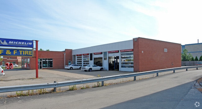
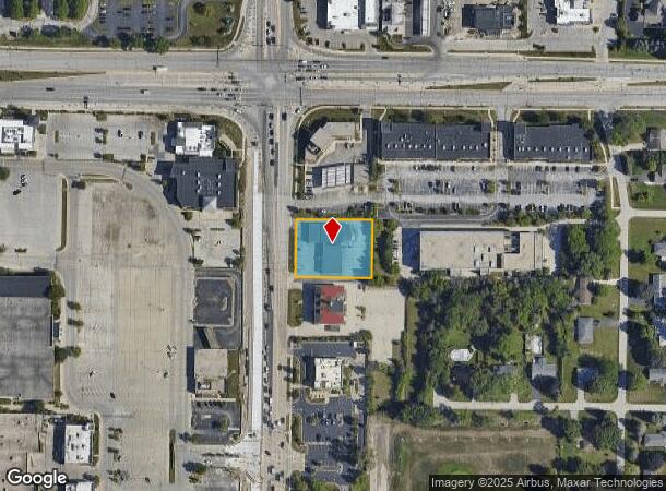
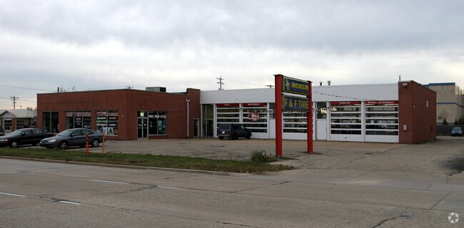
Property Record
410 N Moorland Rd, Brookfield, WI 53005
NEARBY LISTINGS FOR SALE OR LEASE
Property Detail
410 N Moorland Rd
BRC-1111-998
PT SW1/4 SEC 26 T7N R20E COM 1204.14 FT N OF SW COR TH N 152 FT TH E 266.65 FT TH S 152 FT TH W 266.67 FT TO POB EX PART RESERVED FOR ROAD 30,650 SQ FT / .70 ACRE EXCEPT EASEMENT DOC # 4633944 (11/18/2021)
Commercialnec
Waukesha
X
Wisconsin
55133C0236H
0.70 AC
2024
Brookfield/New Berlin
2024
Milwaukee/Madison
201101
Milwaukee-Waukesha-West Allis, WI
DEMOGRAPHICS near 410 N Moorland Rd
1 Mile
3 Mile
5 Mile
2024 Total Population
5,044
57,678
165,318
2029 Population
5,338
59,871
168,394
Pop Growth 2024-2029
+ 5.83%
+ 3.80%
+ 1.86%
Average Age
44
43
43
2024 Total Households
1,973
24,043
70,925
HH Growth 2024-2029
+ 5.98%
+ 3.72%
+ 1.73%
Median Household Inc
$105,765
$94,982
$86,226
Avg Household Size
2.50
2.30
2.30
2024 Avg HH Vehicles
2.00
2.00
2.00
Median Home Value
$409,480
$343,989
$306,360
Median Year Built
1970
1971
1969
Nearby Places
Map Layers
Map Styles
 Street
 Aerial
- Restaurants
- Banks
- Shops
- Fitness
- Groceries
PUBLIC TRANSPORTATION
AIRPORT
General Mitchell International
DRIVE
WALK
Distance
General Mitchell International
29 min
16.6 mi
Nearby Properties
Address
Land Use
TOTAL SIZE
Lot Size
Zoning
Address
Land Use
TOTAL SIZE
Lot Size
Zoning
19.44 AC
Address
Land Use
TOTAL SIZE
Lot Size
Zoning
8.63 AC
C2
Address
Land Use
TOTAL SIZE
Lot Size
Zoning
24.46 AC
Address
Land Use
TOTAL SIZE
Lot Size
Zoning
19.25 AC
Address
Land Use
TOTAL SIZE
Lot Size
Zoning
19.44 AC
Address
Land Use
TOTAL SIZE
Lot Size
Zoning
4.54 AC
Address
Land Use
TOTAL SIZE
Lot Size
Zoning
12.50 AC
Address
Land Use
TOTAL SIZE
Lot Size
Zoning
20.02 AC
Address
Land Use
TOTAL SIZE
Lot Size
Zoning
Address
Land Use
TOTAL SIZE
Lot Size
Zoning
34.31 AC
Address
Land Use
TOTAL SIZE
Lot Size
Zoning
17.45 AC
Address
Land Use
TOTAL SIZE
Lot Size
Zoning
10.48 AC
Address
Land Use
TOTAL SIZE
Lot Size
Zoning
Address
Land Use
TOTAL SIZE
Lot Size
Zoning
7.20 AC
Address
Land Use
TOTAL SIZE
Lot Size
Zoning
Address
Land Use
TOTAL SIZE
Lot Size
Zoning
21.94 AC
Address
Land Use
TOTAL SIZE
Lot Size
Zoning
19.44 AC
Address
Land Use
TOTAL SIZE
Lot Size
Zoning
Address
Land Use
TOTAL SIZE
Lot Size
Zoning
Address
Land Use
TOTAL SIZE
Lot Size
Zoning
3.55 AC
Address
Land Use
TOTAL SIZE
Lot Size
Zoning
230,726 SF
26.56 AC
RM1
Address
Land Use
TOTAL SIZE
Lot Size
Zoning
4.79 AC
Address
Land Use
TOTAL SIZE
Lot Size
Zoning
4.53 AC
Address
Land Use
TOTAL SIZE
Lot Size
Zoning
Address
Land Use
TOTAL SIZE
Lot Size
Zoning
Address
Land Use
TOTAL SIZE
Lot Size
Zoning
Address
Land Use
TOTAL SIZE
Lot Size
Zoning
11.34 AC
Address
Land Use
TOTAL SIZE
Lot Size
Zoning
102,604 SF
12.67 AC
PUD
Address
Land Use
TOTAL SIZE
Lot Size
Zoning
13.14 AC
Address
Land Use
TOTAL SIZE
Lot Size
Zoning
The World's #1 Commercial Real Estate Marketplace
Connect with us
© 2025 CoStar Group
The information above has been obtained from sources believed reliable. While we do not doubt its accuracy we have not verified it and make no guarantee, warranty or representation about it. It is your responsibility to independently confirm its accuracy and completeness. Any projections, opinions, assumptions, or estimates used are for example only and do not represent the current or future performance of the property. The value of this transaction to you depends on tax and other factors which should be evaluated by your tax, financial, and legal advisors. You and your advisors should conduct a careful, independent investigation of the property to determine to your satisfaction the suitability of the property for your needs.