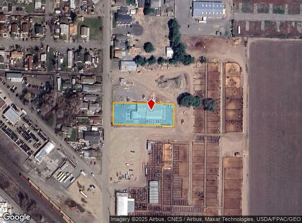
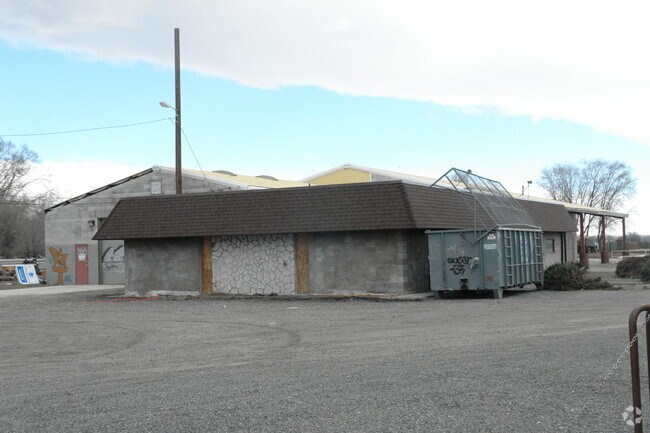
Property Record
410 S G St, Toppenish, WA 98948

NEARBY LISTINGS FOR SALE OR LEASE
Property Detail
410 S G St
Yakima, WA
Wannassay Add
201010-12496
WANNASSAY ADD TO TOPPENISH: LOT 7 BLK 7 ALSO N 10.15 FT OF LOT 8
Utilities
Yakima
AE
Washington
53077C1831D
7,8
2022
0.91 AC
2025
Outlying Yakima County
940006
Yakima
11,265 SF
DEMOGRAPHICS near 410 S G St
1 Mile
3 Mile
5 Mile
2024 Total Population
6,539
12,800
18,605
2029 Population
6,513
12,671
18,406
Pop Growth 2024-2029
(0.40%)
(1.01%)
(1.07%)
Average Age
32
33
34
2024 Total Households
1,744
3,576
5,316
HH Growth 2024-2029
(0.57%)
(1.20%)
(1.30%)
Median Household Inc
$62,033
$60,112
$62,772
Avg Household Size
3.70
3.50
3.40
2024 Avg HH Vehicles
3.00
2.00
2.00
Median Home Value
$156,014
$193,552
$229,333
Median Year Built
1962
1968
1970
Nearby Places
Map Layers
Map Styles
 Street
 Aerial
- Restaurants
- Banks
- Shops
- Fitness
- Groceries
PUBLIC TRANSPORTATION
AIRPORT
Yakima Air Trml/McAllister Field
DRIVE
WALK
Distance
Yakima Air Trml/McAllister Field
31 min
21.4 mi
Freight Ports
Port of Tacoma
DRIVE
WALK
Distance
Port of Tacoma
207 min
175.5 mi
Nearby Properties
Address
Land Use
TOTAL SIZE
Lot Size
Zoning
Address
Land Use
TOTAL SIZE
Lot Size
Zoning
184,462 SF
38.17 AC
PUB
Address
Land Use
TOTAL SIZE
Lot Size
Zoning
324,769 SF
93.16 AC
M1
Address
Land Use
TOTAL SIZE
Lot Size
Zoning
121,029 SF
8.42 AC
M1
Address
Land Use
TOTAL SIZE
Lot Size
Zoning
54,446 SF
26.09 AC
PUB
Address
Land Use
TOTAL SIZE
Lot Size
Zoning
67,287 SF
5.17 AC
B2
Address
Land Use
TOTAL SIZE
Lot Size
Zoning
57,674 SF
31.43 AC
PC
Address
Land Use
TOTAL SIZE
Lot Size
Zoning
278,569 SF
75.58 AC
M1
Address
Land Use
TOTAL SIZE
Lot Size
Zoning
206,804 SF
10.74 AC
M1
Address
Land Use
TOTAL SIZE
Lot Size
Zoning
3.66 AC
PUB
Address
Land Use
TOTAL SIZE
Lot Size
Zoning
80,603 SF
28.65 AC
PUB
Address
Land Use
TOTAL SIZE
Lot Size
Zoning
226,202 SF
8.93 AC
M2
Address
Land Use
TOTAL SIZE
Lot Size
Zoning
115,209 SF
2.52 AC
PUB
Address
Land Use
TOTAL SIZE
Lot Size
Zoning
46,042 SF
5.97 AC
PC
Address
Land Use
TOTAL SIZE
Lot Size
Zoning
278,532 SF
21.25 AC
M2
Address
Land Use
TOTAL SIZE
Lot Size
Zoning
71,077 SF
3.77 AC
PUB
Address
Land Use
TOTAL SIZE
Lot Size
Zoning
22,980 SF
1.83 AC
B1
Address
Land Use
TOTAL SIZE
Lot Size
Zoning
36,868 SF
1.94 AC
B2
Address
Land Use
TOTAL SIZE
Lot Size
Zoning
2,414 SF
195.87 AC
CT
Address
Land Use
TOTAL SIZE
Lot Size
Zoning
44,649 SF
4.50 AC
B2
Address
Land Use
TOTAL SIZE
Lot Size
Zoning
43,044 SF
7.67 AC
TRIB
Address
Land Use
TOTAL SIZE
Lot Size
Zoning
51,985 SF
1.61 AC
CT
Address
Land Use
TOTAL SIZE
Lot Size
Zoning
209,841 SF
15.78 AC
M2
Address
Land Use
TOTAL SIZE
Lot Size
Zoning
21,187 SF
0.75 AC
B2
Address
Land Use
TOTAL SIZE
Lot Size
Zoning
54,333 SF
4.43 AC
C1
Address
Land Use
TOTAL SIZE
Lot Size
Zoning
28,008 SF
2.42 AC
R3
Address
Land Use
TOTAL SIZE
Lot Size
Zoning
8,000 SF
2.71 AC
CT
Address
Land Use
TOTAL SIZE
Lot Size
Zoning
34,523 SF
17.81 AC
R1
Address
Land Use
TOTAL SIZE
Lot Size
Zoning
14,106 SF
5.16 AC
PC
Address
Land Use
TOTAL SIZE
Lot Size
Zoning
4,009 SF
1.11 AC
COM
Address
Land Use
TOTAL SIZE
Lot Size
Zoning
9,100 SF
0.84 AC
C1
The World's #1 Commercial Real Estate Marketplace
Connect with us
© 2026 CoStar Group
The information above has been obtained from sources believed reliable. While we do not doubt its accuracy we have not verified it and make no guarantee, warranty or representation about it. It is your responsibility to independently confirm its accuracy and completeness. Any projections, opinions, assumptions, or estimates used are for example only and do not represent the current or future performance of the property. The value of this transaction to you depends on tax and other factors which should be evaluated by your tax, financial, and legal advisors. You and your advisors should conduct a careful, independent investigation of the property to determine to your satisfaction the suitability of the property for your needs.