Property Record
410 State Route 34 N, Colts Neck, NJ 07722
Current Lease Availabilities
NEARBY LISTINGS FOR SALE OR LEASE
-
-
View all Colts Neck listings for lease on LoopNet.com
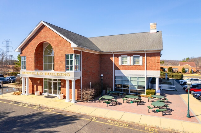
Property Detail
410 State Route 34 N
10-00031-0000-00025-2
Monmouth
Storemultistory
New Jersey
X
25.2
34025C0166F
3.78 AC
2024
Western Monmouth
2025
Northern New Jersey
809901
New York-Jersey City-White Plains, NY-NJ
16,180 SF
DEMOGRAPHICS near 410 State Route 34 N
1 Mile
3 Mile
5 Mile
2024 Total Population
1,041
8,004
43,369
2029 Population
1,031
7,926
42,956
Pop Growth 2024-2029
(0.96%)
(0.97%)
(0.95%)
Average Age
42
41
42
2024 Total Households
339
2,588
14,348
HH Growth 2024-2029
(1.18%)
(1.24%)
(1.12%)
Median Household Inc
$165,625
$192,605
$175,097
Avg Household Size
3.00
3.10
2.90
2024 Avg HH Vehicles
2.00
2.00
2.00
Median Home Value
$840,206
$810,344
$706,145
Median Year Built
1976
1979
1983
Nearby Places
- Restaurants
- Banks
- Shops
- Fitness
- Groceries
PUBLIC TRANSPORTATION
COMMUTER RAIL
Little Silver (North Jersey Coast Line - NJ Transit Commuter Rail (NJ Transit))
DRIVE
WALK
Distance
Little Silver (North Jersey Coast Line - NJ Transit Commuter Rail (NJ Transit))
16 min
9.2 mi
Red Bank (North Jersey Coast Line - NJ Transit Commuter Rail (NJ Transit))
DRIVE
WALK
Distance
Red Bank (North Jersey Coast Line - NJ Transit Commuter Rail (NJ Transit))
16 min
9.4 mi
AIRPORT
Newark Liberty International
DRIVE
WALK
Distance
Newark Liberty International
53 min
43.3 mi
Freight Ports
New York Container Terminal
DRIVE
WALK
Distance
New York Container Terminal
47 min
35.5 mi
Nearby Properties
Address
Land Use
TOTAL SIZE
Lot Size
Zoning
Address
Land Use
TOTAL SIZE
Lot Size
Zoning
3.65 AC
AG
Address
Land Use
TOTAL SIZE
Lot Size
Zoning
69.99 AC
AG
Address
Land Use
TOTAL SIZE
Lot Size
Zoning
241.06 AC
AG
Address
Land Use
TOTAL SIZE
Lot Size
Zoning
1.06 AC
AG
Address
Land Use
TOTAL SIZE
Lot Size
Zoning
22.95 AC
A-1
Address
Land Use
TOTAL SIZE
Lot Size
Zoning
2,860 SF
115.57 AC
P
Address
Land Use
TOTAL SIZE
Lot Size
Zoning
18,128 SF
6 AC
Address
Land Use
TOTAL SIZE
Lot Size
Zoning
4,812 SF
179.80 AC
A-1
Address
Land Use
TOTAL SIZE
Lot Size
Zoning
13,365 SF
3 AC
AG
Address
Land Use
TOTAL SIZE
Lot Size
Zoning
39,321 SF
6.77 AC
C125
Address
Land Use
TOTAL SIZE
Lot Size
Zoning
3,917 SF
66.41 AC
P
Address
Land Use
TOTAL SIZE
Lot Size
Zoning
6,072 SF
31.59 AC
MP
Address
Land Use
TOTAL SIZE
Lot Size
Zoning
17,199 SF
4 AC
Address
Land Use
TOTAL SIZE
Lot Size
Zoning
27.87 AC
A-1
Address
Land Use
TOTAL SIZE
Lot Size
Zoning
75.27 AC
AG
Address
Land Use
TOTAL SIZE
Lot Size
Zoning
15.17 AC
A-1
Address
Land Use
TOTAL SIZE
Lot Size
Zoning
10,734 SF
25.16 AC
AG
Address
Land Use
TOTAL SIZE
Lot Size
Zoning
154,800 SF
19.25 AC
D
Address
Land Use
TOTAL SIZE
Lot Size
Zoning
50,565 SF
4 AC
B
Address
Land Use
TOTAL SIZE
Lot Size
Zoning
13,626 SF
2.35 AC
AG
Address
Land Use
TOTAL SIZE
Lot Size
Zoning
7.84 AC
LI
Address
Land Use
TOTAL SIZE
Lot Size
Zoning
8.27 AC
B-1
Address
Land Use
TOTAL SIZE
Lot Size
Zoning
76,502 SF
8.98 AC
LI
Address
Land Use
TOTAL SIZE
Lot Size
Zoning
17,296 SF
12.54 AC
AG
Address
Land Use
TOTAL SIZE
Lot Size
Zoning
29,202 SF
21.34 AC
5697
Address
Land Use
TOTAL SIZE
Lot Size
Zoning
16,997 SF
4.30 AC
B-2
Address
Land Use
TOTAL SIZE
Lot Size
Zoning
12,339 SF
1 AC
AG
Address
Land Use
TOTAL SIZE
Lot Size
Zoning
13,103 SF
2 AC
Address
Land Use
TOTAL SIZE
Lot Size
Zoning
34.78 AC
P
Address
Land Use
TOTAL SIZE
Lot Size
Zoning
163.69 AC
AG
The World's #1 Commercial Real Estate Marketplace
Connect with us
© 2025 CoStar Group
The information above has been obtained from sources believed reliable. While we do not doubt its accuracy we have not verified it and make no guarantee, warranty or representation about it. It is your responsibility to independently confirm its accuracy and completeness. Any projections, opinions, assumptions, or estimates used are for example only and do not represent the current or future performance of the property. The value of this transaction to you depends on tax and other factors which should be evaluated by your tax, financial, and legal advisors. You and your advisors should conduct a careful, independent investigation of the property to determine to your satisfaction the suitability of the property for your needs.