Property Record
410 Us Highway 181, Gregory, TX 78359
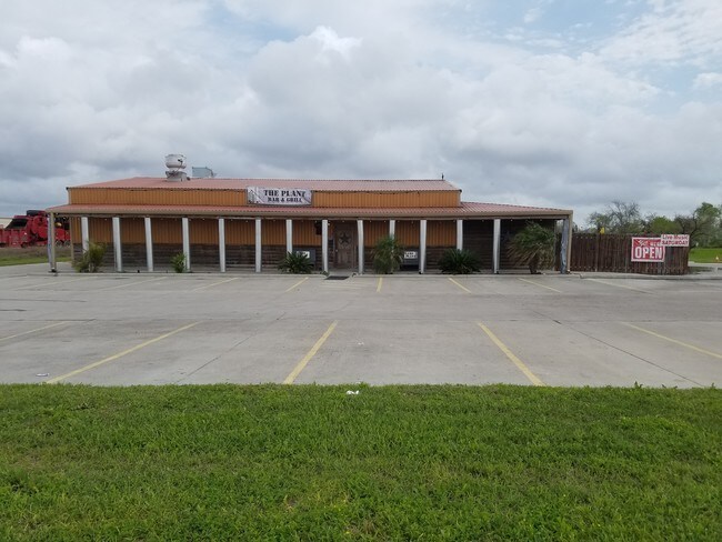

Property Detail
410 Us Highway 181
112093
COLEMAN FULTON PASTURE CO N/W PT SEC O 1.337 ACRES
Commercialnec
SAN PATRICIO
AH Areas with a 1% annual chance of shallow flooding, usually in the form of a pond, withan average depth ranging from 1 to 3 feet. These areas have a 26% chance of flooding over the life of a 30-year mortgage.
Texas
2024
1.34 AC
2025
Portland/Ingleside
010500
Corpus Christi
3,700 SF
Corpus Christi, TX
NEARBY LISTINGS FOR SALE OR LEASE
DEMOGRAPHICS near 410 Us Highway 181
1 mile
3 mile
5 mile
2025 Total Population
1,616
12,633
22,302
2030 Population
1,574
12,856
22,708
Pop Growth 2025-2030
(2.60%)
+ 1.77%
+ 1.82%
Average Age
39
37
37
2025 Total Households
548
4,489
7,972
HH Growth 2025-2030
(2.92%)
+ 1.65%
+ 1.71%
Median Household Inc
$33,902
$71,157
$70,239
Avg Household Size
3.00
2.80
2.70
2025 Avg HH Vehicles
2.00
2.00
2.00
Median Home Value
$99,106
$237,042
$234,011
Median Year Built
1972
1989
1983
Nearby Places
Map Layers
Map Styles
 Street
 Aerial
Transit
 Traffic
 Biking
Places
Listings with unknown addresses are not visible on the map
- Restaurants
- Banks
- Shops
- Fitness
- Groceries
PUBLIC TRANSPORTATION
AIRPORT
Corpus Christi International
Drive
Walk
Distance
Corpus Christi International
28 min
20.4 mi
Freight Ports
Port of Corpus Christi
Drive
Walk
Distance
Port of Corpus Christi
16 min
12.3 mi
SALE & LEASE HISTORY
LISTING DATE
SALE/LEASE

Apr 13, 2018
For Sale
Nearby Properties
Address
Land Use
TOTAL SIZE
Lot Size
Zoning
Address
Land Use
TOTAL SIZE
Lot Size
Zoning
1,350.54 AC
Address
Land Use
TOTAL SIZE
Lot Size
Zoning
267,872 SF
13.26 AC
Address
Land Use
TOTAL SIZE
Lot Size
Zoning
127,781 SF
10.93 AC
Address
Land Use
TOTAL SIZE
Lot Size
Zoning
216,743 SF
12.61 AC
Address
Land Use
TOTAL SIZE
Lot Size
Zoning
188,035 SF
6.18 AC
Address
Land Use
TOTAL SIZE
Lot Size
Zoning
160,529 SF
13.03 AC
Address
Land Use
TOTAL SIZE
Lot Size
Zoning
123,979 SF
28.21 AC
Address
Land Use
TOTAL SIZE
Lot Size
Zoning
Address
Land Use
TOTAL SIZE
Lot Size
Zoning
142,300 SF
14.34 AC
Address
Land Use
TOTAL SIZE
Lot Size
Zoning
230.65 AC
Address
Land Use
TOTAL SIZE
Lot Size
Zoning
147,834 SF
11.09 AC
Address
Land Use
TOTAL SIZE
Lot Size
Zoning
1 SF
52.48 AC
Address
Land Use
TOTAL SIZE
Lot Size
Zoning
151,799 SF
18.93 AC
Address
Land Use
TOTAL SIZE
Lot Size
Zoning
63,524 SF
2.30 AC
Address
Land Use
TOTAL SIZE
Lot Size
Zoning
140.93 AC
Address
Land Use
TOTAL SIZE
Lot Size
Zoning
132.06 AC
Address
Land Use
TOTAL SIZE
Lot Size
Zoning
90,518 SF
4.30 AC
Address
Land Use
TOTAL SIZE
Lot Size
Zoning
35.24 AC
Address
Land Use
TOTAL SIZE
Lot Size
Zoning
37,211 SF
2.26 AC
Address
Land Use
TOTAL SIZE
Lot Size
Zoning
59,159 SF
4.49 AC
Address
Land Use
TOTAL SIZE
Lot Size
Zoning
13,948 SF
2.05 AC
Address
Land Use
TOTAL SIZE
Lot Size
Zoning
21,216 SF
6 AC
Address
Land Use
TOTAL SIZE
Lot Size
Zoning
47,648 SF
1.89 AC
Address
Land Use
TOTAL SIZE
Lot Size
Zoning
48,620 SF
9.64 AC
Address
Land Use
TOTAL SIZE
Lot Size
Zoning
17,324 SF
1.85 AC
Address
Land Use
TOTAL SIZE
Lot Size
Zoning
37,800 SF
6.23 AC
Address
Land Use
TOTAL SIZE
Lot Size
Zoning
83.69 AC
Address
Land Use
TOTAL SIZE
Lot Size
Zoning
55,559 SF
1.54 AC
Address
Land Use
TOTAL SIZE
Lot Size
Zoning
81.15 AC
Address
Land Use
TOTAL SIZE
Lot Size
Zoning
75,672 SF
7.98 AC
The World's #1 Commercial Real Estate Marketplace
Connect with us
© 2026 CoStar Group
The information above has been obtained from sources believed reliable. While we do not doubt its accuracy we have not verified it and make no guarantee, warranty or representation about it. It is your responsibility to independently confirm its accuracy and completeness. Any projections, opinions, assumptions, or estimates used are for example only and do not represent the current or future performance of the property. The value of this transaction to you depends on tax and other factors which should be evaluated by your tax, financial, and legal advisors. You and your advisors should conduct a careful, independent investigation of the property to determine to your satisfaction the suitability of the property for your needs.