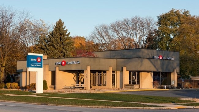
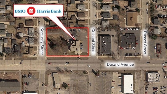
Property Record
4100 Durand Ave, Racine, WI 53405

NEARBY LISTINGS FOR SALE OR LEASE
Property Detail
4100 Durand Ave
276-000023869017
Garden City
Commercialnec
SW 1/4 SECTION 19-3-23 BEG NW COR ORCHARD ST + DURAND AVE, W 270 FT, N 184.37 FT, E 270 FT, S 184.37 FT TO POB EXC PT FOR R/W
X
Racine
55101C0229D
Wisconsin
2024
1.14 AC
2024
Racine East
000901
Milwaukee/Madison
2,835 SF
Racine, WI
DEMOGRAPHICS near 4100 Durand Ave
1 Mile
3 Mile
5 Mile
2024 Total Population
13,112
67,874
121,868
2029 Population
12,967
67,241
121,069
Pop Growth 2024-2029
(1.11%)
(0.93%)
(0.66%)
Average Age
40
39
39
2024 Total Households
5,375
27,735
49,556
HH Growth 2024-2029
(1.15%)
(0.99%)
(0.68%)
Median Household Inc
$55,112
$56,844
$59,941
Avg Household Size
2.40
2.30
2.30
2024 Avg HH Vehicles
2.00
2.00
2.00
Median Home Value
$166,368
$164,900
$179,851
Median Year Built
1962
1958
1963
Nearby Places
Map Layers
Map Styles
 Street
 Aerial
- Restaurants
- Banks
- Shops
- Fitness
- Groceries
PUBLIC TRANSPORTATION
COMMUTER RAIL
DRIVE
WALK
Distance
12 min
6.1 mi
AIRPORT
General Mitchell International
DRIVE
WALK
Distance
General Mitchell International
36 min
25.1 mi
SALE & LEASE HISTORY
LISTING DATE
SALE/LEASE

Oct 23, 2017
For Sale
Nov 16, 2017
For Sale
May 30, 2018
For Sale
Mar 13, 2018
For Sale
Jan 26, 2018
For Sale
Jan 05, 2018
For Sale
Feb 22, 2018
For Sale
Dec 14, 2017
For Sale
Apr 23, 2018
For Sale
Apr 05, 2018
For Sale
Nearby Properties
Address
Land Use
TOTAL SIZE
Lot Size
Zoning
Address
Land Use
TOTAL SIZE
Lot Size
Zoning
22.34 AC
Address
Land Use
TOTAL SIZE
Lot Size
Zoning
47.01 AC
M-1
Address
Land Use
TOTAL SIZE
Lot Size
Zoning
61,744 SF
42.23 AC
OI
Address
Land Use
TOTAL SIZE
Lot Size
Zoning
14.11 AC
I2
Address
Land Use
TOTAL SIZE
Lot Size
Zoning
9.31 AC
Address
Land Use
TOTAL SIZE
Lot Size
Zoning
Address
Land Use
TOTAL SIZE
Lot Size
Zoning
22.98 AC
M-1
Address
Land Use
TOTAL SIZE
Lot Size
Zoning
19.77 AC
B-3
Address
Land Use
TOTAL SIZE
Lot Size
Zoning
6.77 AC
PUL
Address
Land Use
TOTAL SIZE
Lot Size
Zoning
15.81 AC
Address
Land Use
TOTAL SIZE
Lot Size
Zoning
0.11 AC
B-3
Address
Land Use
TOTAL SIZE
Lot Size
Zoning
33.40 AC
I2
Address
Land Use
TOTAL SIZE
Lot Size
Zoning
98.81 AC
Address
Land Use
TOTAL SIZE
Lot Size
Zoning
Address
Land Use
TOTAL SIZE
Lot Size
Zoning
164,201 SF
17 AC
B2
Address
Land Use
TOTAL SIZE
Lot Size
Zoning
Address
Land Use
TOTAL SIZE
Lot Size
Zoning
2.10 AC
Address
Land Use
TOTAL SIZE
Lot Size
Zoning
Address
Land Use
TOTAL SIZE
Lot Size
Zoning
76.18 AC
Address
Land Use
TOTAL SIZE
Lot Size
Zoning
22.72 AC
Address
Land Use
TOTAL SIZE
Lot Size
Zoning
58,485 SF
19.71 AC
I2
Address
Land Use
TOTAL SIZE
Lot Size
Zoning
11.70 AC
M-1
Address
Land Use
TOTAL SIZE
Lot Size
Zoning
Address
Land Use
TOTAL SIZE
Lot Size
Zoning
11.56 AC
Address
Land Use
TOTAL SIZE
Lot Size
Zoning
Address
Land Use
TOTAL SIZE
Lot Size
Zoning
Address
Land Use
TOTAL SIZE
Lot Size
Zoning
102,312 SF
9.92 AC
B2
Address
Land Use
TOTAL SIZE
Lot Size
Zoning
105,550 SF
13.43 AC
Address
Land Use
TOTAL SIZE
Lot Size
Zoning
Address
Land Use
TOTAL SIZE
Lot Size
Zoning
The World's #1 Commercial Real Estate Marketplace
Connect with us
© 2025 CoStar Group
The information above has been obtained from sources believed reliable. While we do not doubt its accuracy we have not verified it and make no guarantee, warranty or representation about it. It is your responsibility to independently confirm its accuracy and completeness. Any projections, opinions, assumptions, or estimates used are for example only and do not represent the current or future performance of the property. The value of this transaction to you depends on tax and other factors which should be evaluated by your tax, financial, and legal advisors. You and your advisors should conduct a careful, independent investigation of the property to determine to your satisfaction the suitability of the property for your needs.