Property Record
4150 Forest Grove Dr, Bettendorf, IA 52722
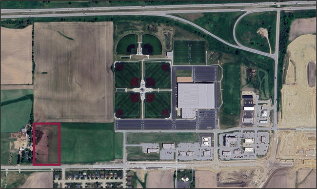
This Property Is For Sale
NEARBY LISTINGS FOR SALE OR LEASE
Property Detail
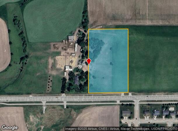
4150 Forest Grove Dr
Davenport-Moline-Rock Island, IA-IL
Metes & Bounds
840217004AD
SEC:02 TWP:78 RNG:04S 770' W 400' SW NW EXC ROW PER DEED 2015-10935
Agriculturalland
Scott
X
Iowa
19163C0378H
6.12 AC
2025
Outlying Scott County
2025
Davenport/Moline/Rock Island
013706
DEMOGRAPHICS near 4150 Forest Grove Dr
1 Mile
3 Mile
5 Mile
2024 Total Population
3,994
29,495
66,632
2029 Population
4,220
29,796
66,821
Pop Growth 2024-2029
+ 5.66%
+ 1.02%
+ 0.28%
Average Age
38
41
41
2024 Total Households
1,456
11,381
27,014
HH Growth 2024-2029
+ 5.49%
+ 0.92%
+ 0.14%
Median Household Inc
$165,813
$119,293
$87,750
Avg Household Size
2.70
2.50
2.40
2024 Avg HH Vehicles
2.00
2.00
2.00
Median Home Value
$462,056
$319,132
$261,769
Median Year Built
2011
1993
1981
Nearby Places
- Restaurants
- Banks
- Shops
- Fitness
- Groceries
PUBLIC TRANSPORTATION
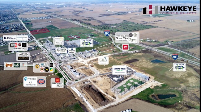
AIRPORT
Quad Cities International
DRIVE
WALK
Distance
Quad Cities International
35 min
27.6 mi
Freight Ports
Port Milwaukee
DRIVE
WALK
Distance
Port Milwaukee
231 min
205.7 mi
Nearby Properties
Address
Land Use
TOTAL SIZE
Lot Size
Zoning
Address
Land Use
TOTAL SIZE
Lot Size
Zoning
157,587 SF
33.92 AC
Address
Land Use
TOTAL SIZE
Lot Size
Zoning
92,431 SF
40.01 AC
Address
Land Use
TOTAL SIZE
Lot Size
Zoning
247,196 SF
13.39 AC
Address
Land Use
TOTAL SIZE
Lot Size
Zoning
2,045 SF
29.48 AC
Address
Land Use
TOTAL SIZE
Lot Size
Zoning
5,400 SF
76.68 AC
Address
Land Use
TOTAL SIZE
Lot Size
Zoning
4,518 SF
6.27 AC
Address
Land Use
TOTAL SIZE
Lot Size
Zoning
50,882 SF
5.10 AC
Address
Land Use
TOTAL SIZE
Lot Size
Zoning
5,296 SF
67.13 AC
Address
Land Use
TOTAL SIZE
Lot Size
Zoning
1,800 SF
60.86 AC
Address
Land Use
TOTAL SIZE
Lot Size
Zoning
133,809 SF
8.26 AC
Address
Land Use
TOTAL SIZE
Lot Size
Zoning
71,820 SF
5.71 AC
Address
Land Use
TOTAL SIZE
Lot Size
Zoning
64,661 SF
147.01 AC
Address
Land Use
TOTAL SIZE
Lot Size
Zoning
84,002 SF
21.76 AC
Address
Land Use
TOTAL SIZE
Lot Size
Zoning
226,764 SF
23.52 AC
Address
Land Use
TOTAL SIZE
Lot Size
Zoning
69,519 SF
5.49 AC
Address
Land Use
TOTAL SIZE
Lot Size
Zoning
118,130 SF
9.32 AC
Address
Land Use
TOTAL SIZE
Lot Size
Zoning
165,770 SF
13.77 AC
Address
Land Use
TOTAL SIZE
Lot Size
Zoning
15,353 SF
3.73 AC
Address
Land Use
TOTAL SIZE
Lot Size
Zoning
61,794 SF
8.83 AC
Address
Land Use
TOTAL SIZE
Lot Size
Zoning
105,195 SF
10.37 AC
Address
Land Use
TOTAL SIZE
Lot Size
Zoning
13,198 SF
11.11 AC
Address
Land Use
TOTAL SIZE
Lot Size
Zoning
42,524 SF
7.18 AC
Address
Land Use
TOTAL SIZE
Lot Size
Zoning
53,320 SF
4.36 AC
Address
Land Use
TOTAL SIZE
Lot Size
Zoning
114,400 SF
23.27 AC
Address
Land Use
TOTAL SIZE
Lot Size
Zoning
85,140 SF
14.25 AC
Address
Land Use
TOTAL SIZE
Lot Size
Zoning
42,912 SF
7.99 AC
Address
Land Use
TOTAL SIZE
Lot Size
Zoning
114,160 SF
2.97 AC
Address
Land Use
TOTAL SIZE
Lot Size
Zoning
73,353 SF
3.45 AC
Address
Land Use
TOTAL SIZE
Lot Size
Zoning
42,912 SF
8.40 AC
Address
Land Use
TOTAL SIZE
Lot Size
Zoning
67,916 SF
6.14 AC
The World's #1 Commercial Real Estate Marketplace
Connect with us
© 2025 CoStar Group
The information above has been obtained from sources believed reliable. While we do not doubt its accuracy we have not verified it and make no guarantee, warranty or representation about it. It is your responsibility to independently confirm its accuracy and completeness. Any projections, opinions, assumptions, or estimates used are for example only and do not represent the current or future performance of the property. The value of this transaction to you depends on tax and other factors which should be evaluated by your tax, financial, and legal advisors. You and your advisors should conduct a careful, independent investigation of the property to determine to your satisfaction the suitability of the property for your needs.