Property Record
4100 Guardian St, Simi Valley, CA 93063
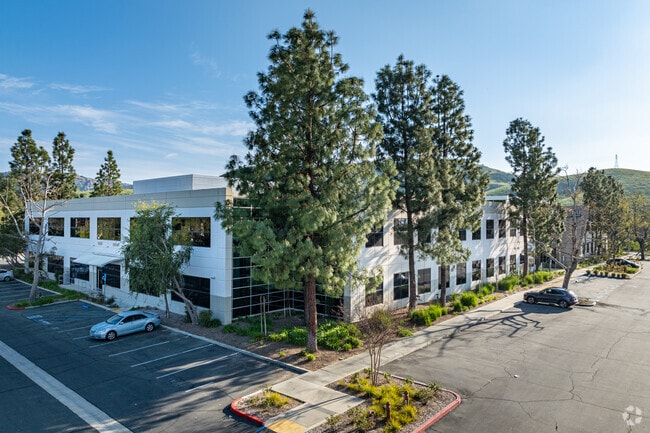


Property Detail
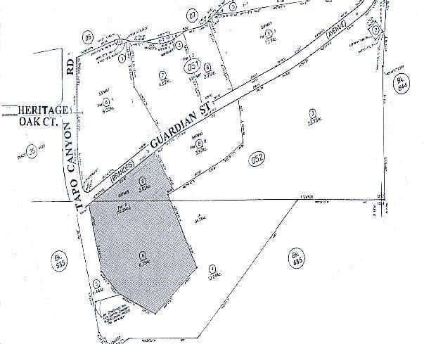
4100 Guardian St
626-0-052-065
REF: 56 PM 99
Officebuilding
Ventura
BP-S
California
B and X Area of moderate flood hazard, usually the area between the limits of the 100-year and 500-year floods.
8.28 AC
2024
Moorpark/Simi Valley
2025
Los Angeles
007512
Oxnard-Thousand Oaks-Ventura, CA
13,585 SF
NEARBY LISTINGS FOR SALE OR LEASE
DEMOGRAPHICS near 4100 Guardian St
1 mile
3 mile
5 mile
2024 Total Population
5,999
82,114
120,353
2029 Population
5,938
81,456
119,337
Pop Growth 2024-2029
(1.02%)
(0.80%)
(0.84%)
Average Age
41
42
42
2024 Total Households
1,913
27,282
40,141
HH Growth 2024-2029
(1.15%)
(1.02%)
(1.04%)
Median Household Inc
$126,199
$118,756
$119,987
Avg Household Size
3.00
2.90
2.90
2024 Avg HH Vehicles
2.00
2.00
2.00
Median Home Value
$752,278
$763,769
$788,821
Median Year Built
1970
1975
1977
Nearby Places
Map Layers
Map Styles
 Street
 Aerial
Transit
 Traffic
 Biking
Places
Listings with unknown addresses are not visible on the map
- Restaurants
- Banks
- Shops
- Fitness
- Groceries
PUBLIC TRANSPORTATION
COMMUTER RAIL
Simi Valley (Ventura County Line - Southern California Regional Rail Authority (Metrolink))
Drive
Walk
Distance
Simi Valley (Ventura County Line - Southern California Regional Rail Authority (Metrolink))
5 min
1.7 mi
AIRPORT
Bob Hope
Drive
Walk
Distance
Bob Hope
34 min
25.5 mi
Los Angeles International
Drive
Walk
Distance
Los Angeles International
54 min
41.4 mi
SALE & LEASE HISTORY
LISTING DATE
SALE/LEASE

Sep 25, 2016
For Lease
Mar 11, 2024
For Lease
Nearby Properties
Address
Land Use
TOTAL SIZE
Lot Size
Zoning
Address
Land Use
TOTAL SIZE
Lot Size
Zoning
4.77 AC
CO
Address
Land Use
TOTAL SIZE
Lot Size
Zoning
57,707 SF
14.76 AC
L-I
Address
Land Use
TOTAL SIZE
Lot Size
Zoning
18,057 SF
10.23 AC
L-I
Address
Land Use
TOTAL SIZE
Lot Size
Zoning
135,768 SF
5.27 AC
Address
Land Use
TOTAL SIZE
Lot Size
Zoning
25,277 SF
14.64 AC
RM-3
Address
Land Use
TOTAL SIZE
Lot Size
Zoning
20,461 SF
2.92 AC
Address
Land Use
TOTAL SIZE
Lot Size
Zoning
3.15 AC
RL-1
Address
Land Use
TOTAL SIZE
Lot Size
Zoning
157,745 SF
7.53 AC
L-I
Address
Land Use
TOTAL SIZE
Lot Size
Zoning
112,130 SF
3.62 AC
Address
Land Use
TOTAL SIZE
Lot Size
Zoning
4.81 AC
Address
Land Use
TOTAL SIZE
Lot Size
Zoning
159,664 SF
7.50 AC
L-I
Address
Land Use
TOTAL SIZE
Lot Size
Zoning
61,020 SF
3.21 AC
Address
Land Use
TOTAL SIZE
Lot Size
Zoning
11,242 SF
13.70 AC
Address
Land Use
TOTAL SIZE
Lot Size
Zoning
157,065 SF
4.30 AC
Address
Land Use
TOTAL SIZE
Lot Size
Zoning
Address
Land Use
TOTAL SIZE
Lot Size
Zoning
1,051.63 AC
OS160AC
Address
Land Use
TOTAL SIZE
Lot Size
Zoning
53,730 SF
2.21 AC
Address
Land Use
TOTAL SIZE
Lot Size
Zoning
2.24 AC
Address
Land Use
TOTAL SIZE
Lot Size
Zoning
19,884 SF
9.24 AC
Address
Land Use
TOTAL SIZE
Lot Size
Zoning
1.39 AC
RM-3
Address
Land Use
TOTAL SIZE
Lot Size
Zoning
Address
Land Use
TOTAL SIZE
Lot Size
Zoning
47,214 SF
1.78 AC
Address
Land Use
TOTAL SIZE
Lot Size
Zoning
78,540 SF
3.75 AC
RH-15
Address
Land Use
TOTAL SIZE
Lot Size
Zoning
15,743 SF
8.12 AC
CPD
Address
Land Use
TOTAL SIZE
Lot Size
Zoning
101,728 SF
5.72 AC
RH-1
Address
Land Use
TOTAL SIZE
Lot Size
Zoning
96,132 SF
4.20 AC
L-I
Address
Land Use
TOTAL SIZE
Lot Size
Zoning
41,130 SF
1.49 AC
The World's #1 Commercial Real Estate Marketplace
Connect with us
© 2026 CoStar Group
The information above has been obtained from sources believed reliable. While we do not doubt its accuracy we have not verified it and make no guarantee, warranty or representation about it. It is your responsibility to independently confirm its accuracy and completeness. Any projections, opinions, assumptions, or estimates used are for example only and do not represent the current or future performance of the property. The value of this transaction to you depends on tax and other factors which should be evaluated by your tax, financial, and legal advisors. You and your advisors should conduct a careful, independent investigation of the property to determine to your satisfaction the suitability of the property for your needs.