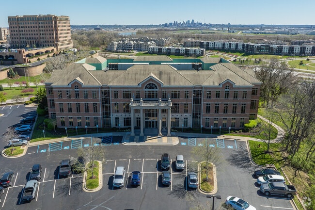
Property Record
4100 N Mulberry Dr, Kansas City, MO 64116


Current Lease Availabilities
NEARBY LISTINGS FOR SALE OR LEASE
Property Detail
4100 N Mulberry Dr
Kansas City, MO-KS
Briarcliff Lake
17-211-00-01-003.02
BRIARCLIFF LAKE LT 3 BCI
Commercialnec
Clay
X
Missouri
29095C0136G
3
2024
7.77 AC
2025
I-35 Corridor
020202
Kansas City
DEMOGRAPHICS near 4100 N Mulberry Dr
1 Mile
3 Mile
5 Mile
2024 Total Population
4,090
49,210
177,275
2029 Population
4,324
51,849
184,054
Pop Growth 2024-2029
+ 5.72%
+ 5.36%
+ 3.82%
Average Age
43
39
38
2024 Total Households
1,991
21,610
75,014
HH Growth 2024-2029
+ 5.73%
+ 5.29%
+ 4.02%
Median Household Inc
$84,984
$57,417
$58,149
Avg Household Size
2.00
2.20
2.20
2024 Avg HH Vehicles
2.00
2.00
2.00
Median Home Value
$298,029
$207,102
$182,719
Median Year Built
1987
1973
1969
Nearby Places
Map Layers
Map Styles
 Street
 Aerial
- Restaurants
- Banks
- Shops
- Fitness
- Groceries
PUBLIC TRANSPORTATION
COMMUTER RAIL
Kansas City (Lincoln Service Missouri River Runner - Amtrak, Missouri River Runner - Amtrak, Southwest Chief - Amtrak)
DRIVE
WALK
Distance
Kansas City (Lincoln Service Missouri River Runner - Amtrak, Missouri River Runner - Amtrak, Southwest Chief - Amtrak)
16 min
7.2 mi
AIRPORT
Kansas City International
DRIVE
WALK
Distance
Kansas City International
21 min
14.5 mi
Freight Ports
Tulsa Port Of Catoosa
DRIVE
WALK
Distance
Tulsa Port Of Catoosa
274 min
244.0 mi
Nearby Properties
Address
Land Use
TOTAL SIZE
Lot Size
Zoning
Address
Land Use
TOTAL SIZE
Lot Size
Zoning
Address
Land Use
TOTAL SIZE
Lot Size
Zoning
8.29 AC
Address
Land Use
TOTAL SIZE
Lot Size
Zoning
846,143 SF
51.25 AC
Address
Land Use
TOTAL SIZE
Lot Size
Zoning
215,920 SF
38.28 AC
Address
Land Use
TOTAL SIZE
Lot Size
Zoning
4,012,734 SF
574.30 AC
KM3
Address
Land Use
TOTAL SIZE
Lot Size
Zoning
Address
Land Use
TOTAL SIZE
Lot Size
Zoning
239,083 SF
85.48 AC
KM3
Address
Land Use
TOTAL SIZE
Lot Size
Zoning
10.97 AC
Address
Land Use
TOTAL SIZE
Lot Size
Zoning
5,044 SF
100.08 AC
Address
Land Use
TOTAL SIZE
Lot Size
Zoning
Address
Land Use
TOTAL SIZE
Lot Size
Zoning
Address
Land Use
TOTAL SIZE
Lot Size
Zoning
46.94 AC
Address
Land Use
TOTAL SIZE
Lot Size
Zoning
491,448 SF
22.53 AC
Address
Land Use
TOTAL SIZE
Lot Size
Zoning
15.16 AC
Address
Land Use
TOTAL SIZE
Lot Size
Zoning
Address
Land Use
TOTAL SIZE
Lot Size
Zoning
20.78 AC
Address
Land Use
TOTAL SIZE
Lot Size
Zoning
31.13 AC
Address
Land Use
TOTAL SIZE
Lot Size
Zoning
Address
Land Use
TOTAL SIZE
Lot Size
Zoning
824,130 SF
20.12 AC
Address
Land Use
TOTAL SIZE
Lot Size
Zoning
552,085 SF
21.81 AC
Address
Land Use
TOTAL SIZE
Lot Size
Zoning
340,930 SF
15.31 AC
Address
Land Use
TOTAL SIZE
Lot Size
Zoning
656,640 SF
20.07 AC
Address
Land Use
TOTAL SIZE
Lot Size
Zoning
271,430 SF
15.70 AC
Address
Land Use
TOTAL SIZE
Lot Size
Zoning
Address
Land Use
TOTAL SIZE
Lot Size
Zoning
179.15 AC
Address
Land Use
TOTAL SIZE
Lot Size
Zoning
9.72 AC
Address
Land Use
TOTAL SIZE
Lot Size
Zoning
245,507 SF
14.22 AC
Address
Land Use
TOTAL SIZE
Lot Size
Zoning
480,000 SF
20.10 AC
Address
Land Use
TOTAL SIZE
Lot Size
Zoning
6.11 AC
Address
Land Use
TOTAL SIZE
Lot Size
Zoning
58.54 AC
The World's #1 Commercial Real Estate Marketplace
Connect with us
© 2026 CoStar Group
The information above has been obtained from sources believed reliable. While we do not doubt its accuracy we have not verified it and make no guarantee, warranty or representation about it. It is your responsibility to independently confirm its accuracy and completeness. Any projections, opinions, assumptions, or estimates used are for example only and do not represent the current or future performance of the property. The value of this transaction to you depends on tax and other factors which should be evaluated by your tax, financial, and legal advisors. You and your advisors should conduct a careful, independent investigation of the property to determine to your satisfaction the suitability of the property for your needs.