Property Record
4100 Stirrup Dr, Greensboro, NC 27407
NEARBY LISTINGS FOR SALE OR LEASE
-
-
View all Greensboro listings for sale on LoopNet.com
Property Detail
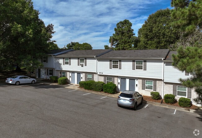
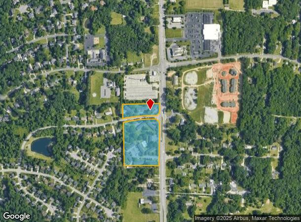
4100 Stirrup Dr
Greensboro-High Point, NC
Hunting Vall
0140822
7.83AC 52-67 PB 16-45 HUNTING VALL PL:16-45
Apartment
Guilford
X
North Carolina
3710784200J
6
2024
7.83 AC
2025
Sedge Field
016502
Greensboro/Winston-Salem
49,920 SF
DEMOGRAPHICS near 4100 Stirrup Dr
1 Mile
3 Mile
5 Mile
2024 Total Population
4,034
48,300
130,925
2029 Population
4,038
48,042
130,413
Pop Growth 2024-2029
+ 0.10%
(0.53%)
(0.39%)
Average Age
42
39
38
2024 Total Households
1,635
19,875
54,770
HH Growth 2024-2029
0.00%
(0.52%)
(0.36%)
Median Household Inc
$60,425
$55,461
$54,735
Avg Household Size
2.40
2.40
2.30
2024 Avg HH Vehicles
2.00
2.00
2.00
Median Home Value
$292,928
$171,508
$172,566
Median Year Built
1985
1986
1985
Nearby Places
Map Layers
Map Styles
 Street
 Aerial
- Restaurants
- Banks
- Shops
- Fitness
- Groceries
PUBLIC TRANSPORTATION
COMMUTER RAIL
Greensboro Station (Piedmont - North Carolina by Train (NC Train))
DRIVE
WALK
Distance
Greensboro Station (Piedmont - North Carolina by Train (NC Train))
12 min
8.4 mi
AIRPORT
Piedmont Triad International
DRIVE
WALK
Distance
Piedmont Triad International
19 min
9.8 mi
Freight Ports
Port of Wilmington
DRIVE
WALK
Distance
Port of Wilmington
248 min
216.0 mi
Nearby Properties
Address
Land Use
TOTAL SIZE
Lot Size
Zoning
Address
Land Use
TOTAL SIZE
Lot Size
Zoning
1,307,155 SF
60.56 AC
C-H
Address
Land Use
TOTAL SIZE
Lot Size
Zoning
957,290 SF
18.71 AC
C-H
Address
Land Use
TOTAL SIZE
Lot Size
Zoning
412,635 SF
37.70 AC
RM-12
Address
Land Use
TOTAL SIZE
Lot Size
Zoning
275,782 SF
27.65 AC
RM-12
Address
Land Use
TOTAL SIZE
Lot Size
Zoning
341,210 SF
13.43 AC
PUD
Address
Land Use
TOTAL SIZE
Lot Size
Zoning
536,466 SF
46.90 AC
PUD
Address
Land Use
TOTAL SIZE
Lot Size
Zoning
279,853 SF
19.80 AC
RM-18
Address
Land Use
TOTAL SIZE
Lot Size
Zoning
138,843 SF
115.56 AC
CU-LI
Address
Land Use
TOTAL SIZE
Lot Size
Zoning
312,732 SF
14.27 AC
RM-18
Address
Land Use
TOTAL SIZE
Lot Size
Zoning
252,351 SF
9.48 AC
RM-18
Address
Land Use
TOTAL SIZE
Lot Size
Zoning
228,994 SF
15.59 AC
PUD
Address
Land Use
TOTAL SIZE
Lot Size
Zoning
231,597 SF
8.46 AC
PD-R
Address
Land Use
TOTAL SIZE
Lot Size
Zoning
395,043 SF
15.74 AC
PUD
Address
Land Use
TOTAL SIZE
Lot Size
Zoning
256,423 SF
20.64 AC
PUD
Address
Land Use
TOTAL SIZE
Lot Size
Zoning
177,780 SF
11.80 AC
PUD
Address
Land Use
TOTAL SIZE
Lot Size
Zoning
182,499 SF
6.74 AC
O
Address
Land Use
TOTAL SIZE
Lot Size
Zoning
116,713 SF
4.53 AC
C-M
Address
Land Use
TOTAL SIZE
Lot Size
Zoning
193,705 SF
14.35 AC
PUD
Address
Land Use
TOTAL SIZE
Lot Size
Zoning
211,723 SF
20.24 AC
RM-18
Address
Land Use
TOTAL SIZE
Lot Size
Zoning
144,746 SF
8.17 AC
AG
Address
Land Use
TOTAL SIZE
Lot Size
Zoning
250,084 SF
5.46 AC
PI
Address
Land Use
TOTAL SIZE
Lot Size
Zoning
193,716 SF
10.81 AC
RM-18
Address
Land Use
TOTAL SIZE
Lot Size
Zoning
173,887 SF
12.46 AC
RM-18
Address
Land Use
TOTAL SIZE
Lot Size
Zoning
173,492 SF
21.93 AC
RM-12
Address
Land Use
TOTAL SIZE
Lot Size
Zoning
188,976 SF
41.46 AC
R-5
Address
Land Use
TOTAL SIZE
Lot Size
Zoning
133,900 SF
9.12 AC
BP
Address
Land Use
TOTAL SIZE
Lot Size
Zoning
272,917 SF
33.57 AC
MS
Address
Land Use
TOTAL SIZE
Lot Size
Zoning
123,560 SF
5.18 AC
RM-18
Address
Land Use
TOTAL SIZE
Lot Size
Zoning
134,008 SF
10.48 AC
RM-18
Address
Land Use
TOTAL SIZE
Lot Size
Zoning
120,552 SF
15.03 AC
RM-12
The World's #1 Commercial Real Estate Marketplace
Connect with us
© 2025 CoStar Group
The information above has been obtained from sources believed reliable. While we do not doubt its accuracy we have not verified it and make no guarantee, warranty or representation about it. It is your responsibility to independently confirm its accuracy and completeness. Any projections, opinions, assumptions, or estimates used are for example only and do not represent the current or future performance of the property. The value of this transaction to you depends on tax and other factors which should be evaluated by your tax, financial, and legal advisors. You and your advisors should conduct a careful, independent investigation of the property to determine to your satisfaction the suitability of the property for your needs.