Property Record
4100 Sw Empire Dr, Prineville, OR 97754
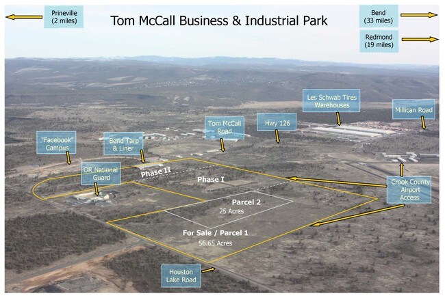

Property Detail
4100 Sw Empire Dr
Bend, OR
SECTION 02 TOWNSHIP 15S RANGE 15E PCRL 300 SUBDIVISION: PP 2024-19 MAPTAXLOT: 1515020000300
014541
CROOK
Industrialacreage
Oregon
M1
10
B and X Area of moderate flood hazard, usually the area between the limits of the 100-year and 500-year floods.
45.66 AC
2025
Crook County
2025
Other Market Areas
950200
NEARBY LISTINGS FOR SALE OR LEASE
DEMOGRAPHICS near 4100 Sw Empire Dr
1 mile
3 mile
5 mile
2025 Total Population
22
1,132
14,381
2030 Population
23
1,225
15,372
Pop Growth 2025-2030
+ 4.55%
+ 8.22%
+ 6.89%
Average Age
47
44
42
2025 Total Households
8
436
5,729
HH Growth 2025-2030
+ 12.50%
+ 8.26%
+ 7.02%
Median Household Inc
$67,500
$71,120
$73,908
Avg Household Size
2.50
2.60
2.40
2025 Avg HH Vehicles
2.00
2.00
2.00
Median Home Value
$625,000
$608,418
$426,677
Median Year Built
1984
1991
1989
Nearby Places
Map Layers
Map Styles
 Street
 Aerial
Layers
 Traffic
 Biking
Places
Listings with unknown addresses are not visible on the map
- Restaurants
- Banks
- Shops
- Fitness
- Groceries
PUBLIC TRANSPORTATION
AIRPORT
Roberts Field
Drive
Walk
Distance
Roberts Field
24 min
17.4 mi
Freight Ports
Port of Portland
Drive
Walk
Distance
Port of Portland
227 min
153.4 mi
Nearby Properties
Address
Land Use
TOTAL SIZE
Lot Size
Zoning
Address
Land Use
TOTAL SIZE
Lot Size
Zoning
68,850 SF
1.38 AC
C1
Address
Land Use
TOTAL SIZE
Lot Size
Zoning
1 SF
50 AC
IP
Address
Land Use
TOTAL SIZE
Lot Size
Zoning
5,240 SF
449.07 AC
HM
Address
Land Use
TOTAL SIZE
Lot Size
Zoning
5,240 SF
795.50 AC
AC
Address
Land Use
TOTAL SIZE
Lot Size
Zoning
202.87 AC
PR
Address
Land Use
TOTAL SIZE
Lot Size
Zoning
33,854 SF
1.52 AC
R4
Address
Land Use
TOTAL SIZE
Lot Size
Zoning
7,089 SF
46.68 AC
C5
Address
Land Use
TOTAL SIZE
Lot Size
Zoning
1 SF
1.25 AC
R2
Address
Land Use
TOTAL SIZE
Lot Size
Zoning
83,366 SF
2.10 AC
M1
Address
Land Use
TOTAL SIZE
Lot Size
Zoning
80.35 AC
M1
Address
Land Use
TOTAL SIZE
Lot Size
Zoning
5.15 AC
M1
Address
Land Use
TOTAL SIZE
Lot Size
Zoning
Address
Land Use
TOTAL SIZE
Lot Size
Zoning
1 SF
15.48 AC
IP
Address
Land Use
TOTAL SIZE
Lot Size
Zoning
12,887 SF
0.70 AC
C1
Address
Land Use
TOTAL SIZE
Lot Size
Zoning
57,708 SF
7.63 AC
HM
Address
Land Use
TOTAL SIZE
Lot Size
Zoning
1 SF
22.48 AC
M2
Address
Land Use
TOTAL SIZE
Lot Size
Zoning
59,500 SF
5.08 AC
IP
Address
Land Use
TOTAL SIZE
Lot Size
Zoning
1.22 AC
R2
Address
Land Use
TOTAL SIZE
Lot Size
Zoning
10,800 SF
5.51 AC
IP
Address
Land Use
TOTAL SIZE
Lot Size
Zoning
78.81 AC
M1
Address
Land Use
TOTAL SIZE
Lot Size
Zoning
15,026 SF
0.18 AC
C1
Address
Land Use
TOTAL SIZE
Lot Size
Zoning
13,720 SF
1.50 AC
IP
Address
Land Use
TOTAL SIZE
Lot Size
Zoning
75.31 AC
IP
Address
Land Use
TOTAL SIZE
Lot Size
Zoning
9,640 SF
2.54 AC
IP
Address
Land Use
TOTAL SIZE
Lot Size
Zoning
12,826 SF
0.54 AC
R2
Address
Land Use
TOTAL SIZE
Lot Size
Zoning
39,953 SF
2.07 AC
C2
Address
Land Use
TOTAL SIZE
Lot Size
Zoning
1 SF
2.51 AC
M2
Address
Land Use
TOTAL SIZE
Lot Size
Zoning
15,545 SF
2.32 AC
R4
Address
Land Use
TOTAL SIZE
Lot Size
Zoning
22,029 SF
15.85 AC
HM
Address
Land Use
TOTAL SIZE
Lot Size
Zoning
25,823 SF
3.22 AC
R2
The World's #1 Commercial Real Estate Marketplace
Connect with us
© 2026 CoStar Group
The information above has been obtained from sources believed reliable. While we do not doubt its accuracy we have not verified it and make no guarantee, warranty or representation about it. It is your responsibility to independently confirm its accuracy and completeness. Any projections, opinions, assumptions, or estimates used are for example only and do not represent the current or future performance of the property. The value of this transaction to you depends on tax and other factors which should be evaluated by your tax, financial, and legal advisors. You and your advisors should conduct a careful, independent investigation of the property to determine to your satisfaction the suitability of the property for your needs.