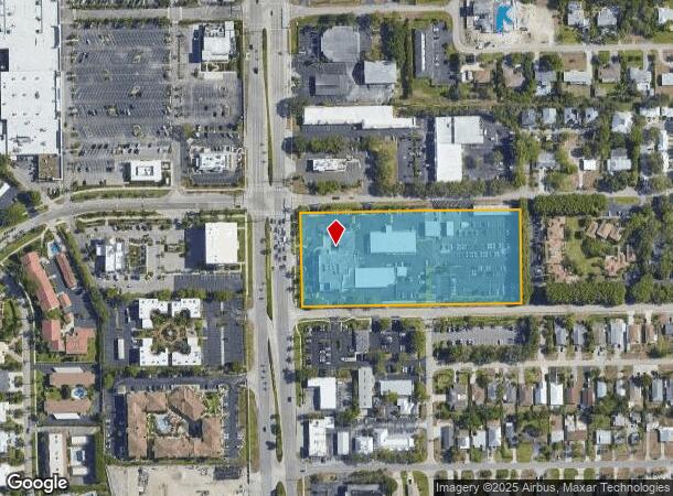
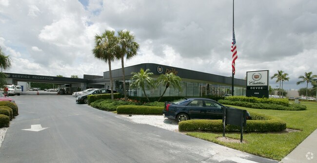
Property Record
4100 Tamiami Trl N, Naples, FL 34103

NEARBY LISTINGS FOR SALE OR LEASE
Property Detail
4100 Tamiami Trl N
Naples-Immokalee-Marco Island, FL
Naples Imp Co Little Farms
61944360007
N I C L F 15 49 25 W 400FT OF N 301FT OF LOT 66, AND N I C L F COMM NE CNR LOT 66, ALG NORTH LINE OF SAID LOT 66 N 89DEG W 1886.82FT TO POB; S 0DEG W 301.38FT TO NORTH R/W LINE OF SOLANA RD, ALG N R/W LINE N 89DEG W 300FT TO SE CNR OF PARCEL DESC IN
Autorepair
Collier
AH
Florida
12021C0383J
66
2024
4.84 AC
2025
North Naples
010300
Southwest Florida
34,542 SF
DEMOGRAPHICS near 4100 Tamiami Trl N
1 Mile
3 Mile
5 Mile
2024 Total Population
10,432
45,639
104,260
2029 Population
12,041
52,484
119,556
Pop Growth 2024-2029
+ 15.42%
+ 15.00%
+ 14.67%
Average Age
56
55
53
2024 Total Households
5,043
22,391
49,266
HH Growth 2024-2029
+ 15.33%
+ 14.84%
+ 14.59%
Median Household Inc
$95,842
$99,747
$86,268
Avg Household Size
1.90
1.90
2.00
2024 Avg HH Vehicles
2.00
2.00
2.00
Median Home Value
$873,312
$831,927
$648,878
Median Year Built
1981
1986
1990
Nearby Places
Map Layers
Map Styles
 Street
 Aerial
- Restaurants
- Banks
- Shops
- Fitness
- Groceries
PUBLIC TRANSPORTATION
AIRPORT
Southwest Florida International
DRIVE
WALK
Distance
Southwest Florida International
43 min
32.1 mi
Freight Ports
Port Everglades
DRIVE
WALK
Distance
Port Everglades
124 min
108.6 mi
Nearby Properties
Address
Land Use
TOTAL SIZE
Lot Size
Zoning
Address
Land Use
TOTAL SIZE
Lot Size
Zoning
905,326 SF
69.45 AC
GC
Address
Land Use
TOTAL SIZE
Lot Size
Zoning
Address
Land Use
TOTAL SIZE
Lot Size
Zoning
1,850 SF
5.20 AC
Address
Land Use
TOTAL SIZE
Lot Size
Zoning
2,440 SF
3.99 AC
NAPLES
Address
Land Use
TOTAL SIZE
Lot Size
Zoning
123,282 SF
6.50 AC
PUD
Address
Land Use
TOTAL SIZE
Lot Size
Zoning
250,674 SF
33.61 AC
NAPLES
Address
Land Use
TOTAL SIZE
Lot Size
Zoning
936 SF
2.47 AC
Address
Land Use
TOTAL SIZE
Lot Size
Zoning
398,094 SF
17.31 AC
A
Address
Land Use
TOTAL SIZE
Lot Size
Zoning
363,275 SF
21.02 AC
PUD
Address
Land Use
TOTAL SIZE
Lot Size
Zoning
26,296 SF
2.10 AC
Address
Land Use
TOTAL SIZE
Lot Size
Zoning
418,075 SF
38.19 AC
Address
Land Use
TOTAL SIZE
Lot Size
Zoning
453,819 SF
4.53 AC
Address
Land Use
TOTAL SIZE
Lot Size
Zoning
291,699 SF
18.17 AC
PUD
Address
Land Use
TOTAL SIZE
Lot Size
Zoning
932,389 SF
36.28 AC
NAPLES
Address
Land Use
TOTAL SIZE
Lot Size
Zoning
256,507 SF
26.32 AC
PUD
Address
Land Use
TOTAL SIZE
Lot Size
Zoning
137,799 SF
5.78 AC
Address
Land Use
TOTAL SIZE
Lot Size
Zoning
72,844 SF
15.94 AC
RSF-1
Address
Land Use
TOTAL SIZE
Lot Size
Zoning
159,901 SF
10.08 AC
RMF-16
Address
Land Use
TOTAL SIZE
Lot Size
Zoning
277,290 SF
31.01 AC
PUD
Address
Land Use
TOTAL SIZE
Lot Size
Zoning
71,516 SF
2.88 AC
NAPLES
Address
Land Use
TOTAL SIZE
Lot Size
Zoning
255,522 SF
21.83 AC
NAPLES
Address
Land Use
TOTAL SIZE
Lot Size
Zoning
82,382 SF
9.98 AC
PUD
Address
Land Use
TOTAL SIZE
Lot Size
Zoning
61,910 SF
45.05 AC
A
Address
Land Use
TOTAL SIZE
Lot Size
Zoning
203,171 SF
16.64 AC
NAPLES
Address
Land Use
TOTAL SIZE
Lot Size
Zoning
134,551 SF
19.50 AC
PUD
Address
Land Use
TOTAL SIZE
Lot Size
Zoning
1,388 SF
6.89 AC
NAPLES
Address
Land Use
TOTAL SIZE
Lot Size
Zoning
145,061 SF
18.82 AC
PUD
Address
Land Use
TOTAL SIZE
Lot Size
Zoning
164,004 SF
2.66 AC
Address
Land Use
TOTAL SIZE
Lot Size
Zoning
133,302 SF
3.82 AC
NAPLES
Address
Land Use
TOTAL SIZE
Lot Size
Zoning
89,691 SF
3.42 AC
The World's #1 Commercial Real Estate Marketplace
Connect with us
© 2025 CoStar Group
The information above has been obtained from sources believed reliable. While we do not doubt its accuracy we have not verified it and make no guarantee, warranty or representation about it. It is your responsibility to independently confirm its accuracy and completeness. Any projections, opinions, assumptions, or estimates used are for example only and do not represent the current or future performance of the property. The value of this transaction to you depends on tax and other factors which should be evaluated by your tax, financial, and legal advisors. You and your advisors should conduct a careful, independent investigation of the property to determine to your satisfaction the suitability of the property for your needs.