Property Record
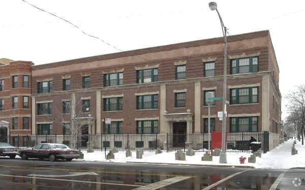
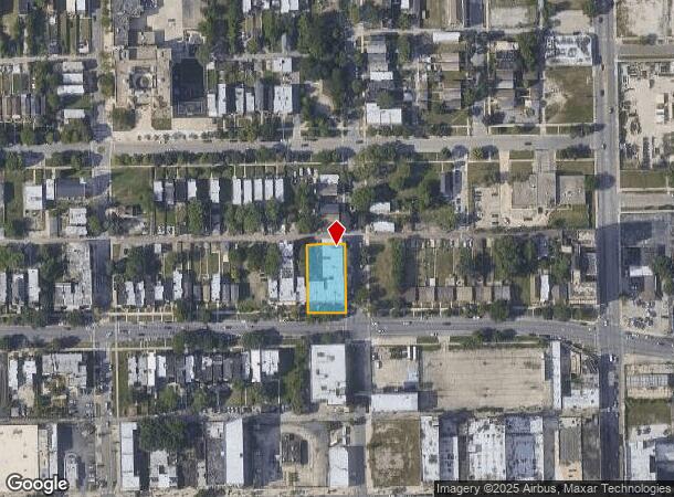
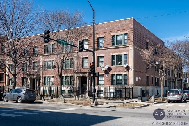
4100 W Washington Blvd, Chicago, IL 60624

This Property Is For Sale
NEARBY LISTINGS FOR SALE OR LEASE
Property Detail
4100 W Washington Blvd
Chicago-Naperville-Elgin, IL-IN-WI
West Chicago Land
16-10-420-042-0000
(WEST) (CHICAGO) (LAND) COS SUB OF SH SEC 10-39-13
Apartment
Cook
X
Illinois
17031C0415J
45,46
2023
0.42 AC
2024
West Garfield Park
260200
Chicago
30,678 SF
DEMOGRAPHICS near 4100 W Washington Blvd
1 Mile
3 Mile
5 Mile
2024 Total Population
28,013
355,728
975,739
2029 Population
26,235
330,553
920,821
Pop Growth 2024-2029
(6.35%)
(7.08%)
(5.63%)
Average Age
37
36
37
2024 Total Households
10,444
129,129
381,019
HH Growth 2024-2029
(6.82%)
(7.29%)
(5.50%)
Median Household Inc
$30,374
$50,781
$74,633
Avg Household Size
2.50
2.60
2.40
2024 Avg HH Vehicles
1.00
1.00
1.00
Median Home Value
$206,779
$281,479
$357,664
Median Year Built
1948
1947
1948
Nearby Places
- Restaurants
- Banks
- Shops
- Fitness
- Groceries
PUBLIC TRANSPORTATION
TRANSIT/SUBWAY
Pulaski Station (Green Line) (Green Line - Chicago Transit Authority "L" Trains (The "L"))
DRIVE
WALK
Distance
Pulaski Station (Green Line) (Green Line - Chicago Transit Authority "L" Trains (The "L"))
1 min
6 min
0.3 mi
Conservatory-Central Park Drive Station (Green Line - Chicago Transit Authority "L" Trains (The "L"))
DRIVE
WALK
Distance
Conservatory-Central Park Drive Station (Green Line - Chicago Transit Authority "L" Trains (The "L"))
2 min
15 min
0.8 mi
Pulaski Station (Blue Line - Forest Park Branch) (Blue Line - Chicago Transit Authority "L" Trains (The "L"))
DRIVE
WALK
Distance
Pulaski Station (Blue Line - Forest Park Branch) (Blue Line - Chicago Transit Authority "L" Trains (The "L"))
3 min
15 min
0.8 mi
Cicero Station (Green Line) (Green Line - Chicago Transit Authority "L" Trains (The "L"))
DRIVE
WALK
Distance
Cicero Station (Green Line) (Green Line - Chicago Transit Authority "L" Trains (The "L"))
3 min
20 min
1.0 mi
COMMUTER RAIL
Kedzie Station (Union Pacific West Line - Northeast Illinois Regional Commuter Railroad (Metra))
DRIVE
WALK
Distance
Kedzie Station (Union Pacific West Line - Northeast Illinois Regional Commuter Railroad (Metra))
4 min
1.6 mi
Western Avenue Station (MD-N/MD-W/NCS) (Milwaukee District North Line - Northeast Illinois Regional Commuter Railroad (Metra), Milwaukee District West Line - Northeast Illinois Regional Commuter Railroad (Metra), North Central Service - Northeast Illinois Regional Commuter Railroad (Metra))
DRIVE
WALK
Distance
Western Avenue Station (MD-N/MD-W/NCS) (Milwaukee District North Line - Northeast Illinois Regional Commuter Railroad (Metra), Milwaukee District West Line - Northeast Illinois Regional Commuter Railroad (Metra), North Central Service - Northeast Illinois Regional Commuter Railroad (Metra))
7 min
2.8 mi
AIRPORT
Chicago Midway International
DRIVE
WALK
Distance
Chicago Midway International
15 min
8.0 mi
Chicago O'Hare International
DRIVE
WALK
Distance
Chicago O'Hare International
27 min
15.2 mi
Nearby Properties
Address
Land Use
TOTAL SIZE
Lot Size
Zoning
Address
Land Use
TOTAL SIZE
Lot Size
Zoning
73,700 SF
0.48 AC
RM-6.5
Address
Land Use
TOTAL SIZE
Lot Size
Zoning
3.29 AC
PD 522
Address
Land Use
TOTAL SIZE
Lot Size
Zoning
2.67 AC
PD 522
Address
Land Use
TOTAL SIZE
Lot Size
Zoning
86,928 SF
4.80 AC
PD 933
Address
Land Use
TOTAL SIZE
Lot Size
Zoning
0.66 AC
RS-3
Address
Land Use
TOTAL SIZE
Lot Size
Zoning
1,313,541 SF
44.90 AC
M2-2
Address
Land Use
TOTAL SIZE
Lot Size
Zoning
4.85 AC
PD 1505
Address
Land Use
TOTAL SIZE
Lot Size
Zoning
1,220,173 SF
26.53 AC
M2-2
Address
Land Use
TOTAL SIZE
Lot Size
Zoning
333,340 SF
Address
Land Use
TOTAL SIZE
Lot Size
Zoning
32,500 SF
0.56 AC
RT-4
Address
Land Use
TOTAL SIZE
Lot Size
Zoning
194,582 SF
12.68 AC
PD 699
Address
Land Use
TOTAL SIZE
Lot Size
Zoning
382,635 SF
5.90 AC
M1-1
Address
Land Use
TOTAL SIZE
Lot Size
Zoning
0.58 AC
B3-2
Address
Land Use
TOTAL SIZE
Lot Size
Zoning
1.97 AC
PD 30
Address
Land Use
TOTAL SIZE
Lot Size
Zoning
129,379 SF
1.57 AC
PD 1309
Address
Land Use
TOTAL SIZE
Lot Size
Zoning
291,681 SF
14.04 AC
Address
Land Use
TOTAL SIZE
Lot Size
Zoning
10,400 SF
0.20 AC
B3-5
Address
Land Use
TOTAL SIZE
Lot Size
Zoning
226,155 SF
5.86 AC
PMD 9
Address
Land Use
TOTAL SIZE
Lot Size
Zoning
578,024 SF
31.94 AC
Address
Land Use
TOTAL SIZE
Lot Size
Zoning
0.66 AC
PD 852
Address
Land Use
TOTAL SIZE
Lot Size
Zoning
93,409 SF
2.05 AC
PD 146
Address
Land Use
TOTAL SIZE
Lot Size
Zoning
389,400 SF
28.83 AC
PMD 9
Address
Land Use
TOTAL SIZE
Lot Size
Zoning
232,071 SF
Address
Land Use
TOTAL SIZE
Lot Size
Zoning
1,300 SF
0.07 AC
B3-5
Address
Land Use
TOTAL SIZE
Lot Size
Zoning
9,000 SF
0.34 AC
Address
Land Use
TOTAL SIZE
Lot Size
Zoning
7.68 AC
Address
Land Use
TOTAL SIZE
Lot Size
Zoning
900 SF
29.73 AC
PD 1454
Address
Land Use
TOTAL SIZE
Lot Size
Zoning
43,800 SF
0.94 AC
M1-2
Address
Land Use
TOTAL SIZE
Lot Size
Zoning
0.41 AC
RT-4
Address
Land Use
TOTAL SIZE
Lot Size
Zoning
15.25 AC
The World's #1 Commercial Real Estate Marketplace
Connect with us
© 2025 CoStar Group
The information above has been obtained from sources believed reliable. While we do not doubt its accuracy we have not verified it and make no guarantee, warranty or representation about it. It is your responsibility to independently confirm its accuracy and completeness. Any projections, opinions, assumptions, or estimates used are for example only and do not represent the current or future performance of the property. The value of this transaction to you depends on tax and other factors which should be evaluated by your tax, financial, and legal advisors. You and your advisors should conduct a careful, independent investigation of the property to determine to your satisfaction the suitability of the property for your needs.