Property Record
4101 E Royalton Rd, Broadview Hts, OH 44147
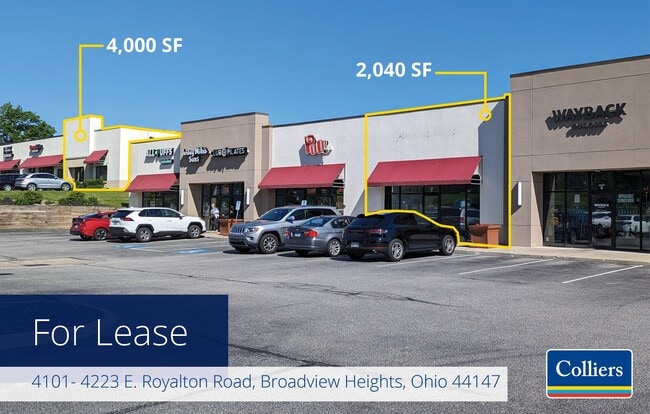


Current Lease Availabilities
General Retail LEASE
Negotiable
2,040 - 4,000 SF
NEARBY LISTINGS FOR SALE OR LEASE
Property Detail
4101 E Royalton Rd
Cleveland-Elyria, OH
Royal Industrial Park Subdivision
583-18-010
LISTED WITH 58318301 & 58318302 VOL 164 PG 37-39 2010A/R
Miscellaneous
Cuyahoga
0
Ohio
2024
South
136104
Cleveland
DEMOGRAPHICS near 4101 E Royalton Rd
1 Mile
3 Mile
5 Mile
2024 Total Population
1,790
31,958
77,532
2029 Population
1,725
31,002
75,247
Pop Growth 2024-2029
(3.63%)
(2.99%)
(2.95%)
Average Age
44
43
45
2024 Total Households
666
12,987
31,908
HH Growth 2024-2029
(3.90%)
(3.19%)
(3.14%)
Median Household Inc
$116,383
$99,404
$92,746
Avg Household Size
2.60
2.40
2.40
2024 Avg HH Vehicles
2.00
2.00
2.00
Median Home Value
$309,032
$298,536
$264,960
Median Year Built
1977
1980
1975
Nearby Places
Map Layers
Map Styles
 Street
 Aerial
- Restaurants
- Banks
- Shops
- Fitness
- Groceries
PUBLIC TRANSPORTATION
COMMUTER RAIL
DRIVE
WALK
Distance
10 min
4.2 mi
DRIVE
WALK
Distance
13 min
6.9 mi
AIRPORT
Cleveland-Hopkins International
DRIVE
WALK
Distance
Cleveland-Hopkins International
32 min
19.1 mi
Akron-Canton Regional
DRIVE
WALK
Distance
Akron-Canton Regional
47 min
36.8 mi
Nearby Properties
Address
Land Use
TOTAL SIZE
Lot Size
Zoning
Address
Land Use
TOTAL SIZE
Lot Size
Zoning
105,027 SF
14.05 AC
O-L
Address
Land Use
TOTAL SIZE
Lot Size
Zoning
118.84 AC
L-B
Address
Land Use
TOTAL SIZE
Lot Size
Zoning
228,253 SF
32.51 AC
C-F
Address
Land Use
TOTAL SIZE
Lot Size
Zoning
285,065 SF
5.43 AC
D-1
Address
Land Use
TOTAL SIZE
Lot Size
Zoning
496.33 AC
C-F
Address
Land Use
TOTAL SIZE
Lot Size
Zoning
105,106 SF
20.67 AC
C-F
Address
Land Use
TOTAL SIZE
Lot Size
Zoning
306,640 SF
19.15 AC
M-D
Address
Land Use
TOTAL SIZE
Lot Size
Zoning
166,699 SF
65.80 AC
B-5
Address
Land Use
TOTAL SIZE
Lot Size
Zoning
48,682 SF
4.64 AC
C-4
Address
Land Use
TOTAL SIZE
Lot Size
Zoning
63,282 SF
20.09 AC
O-B
Address
Land Use
TOTAL SIZE
Lot Size
Zoning
196,491 SF
2.56 AC
R-20
Address
Land Use
TOTAL SIZE
Lot Size
Zoning
28,189 SF
15.33 AC
B-1OR2
Address
Land Use
TOTAL SIZE
Lot Size
Zoning
73.13 AC
C-F
Address
Land Use
TOTAL SIZE
Lot Size
Zoning
6,395 SF
0.23 AC
O-L
Address
Land Use
TOTAL SIZE
Lot Size
Zoning
94,997 SF
10.93 AC
L-B
Address
Land Use
TOTAL SIZE
Lot Size
Zoning
337,568 SF
26.88 AC
O-L
Address
Land Use
TOTAL SIZE
Lot Size
Zoning
207,280 SF
18.60 AC
M-D
Address
Land Use
TOTAL SIZE
Lot Size
Zoning
188,503 SF
23.72 AC
D-1
Address
Land Use
TOTAL SIZE
Lot Size
Zoning
80,559 SF
4.07 AC
R-20
Address
Land Use
TOTAL SIZE
Lot Size
Zoning
24,900 SF
4.42 AC
B-1OR2
Address
Land Use
TOTAL SIZE
Lot Size
Zoning
55,332 SF
3.01 AC
E-2
Address
Land Use
TOTAL SIZE
Lot Size
Zoning
89,807 SF
7.29 AC
Address
Land Use
TOTAL SIZE
Lot Size
Zoning
49,470 SF
6.61 AC
E-1
Address
Land Use
TOTAL SIZE
Lot Size
Zoning
83,495 SF
9.70 AC
E-1
Address
Land Use
TOTAL SIZE
Lot Size
Zoning
509.96 AC
C-F
Address
Land Use
TOTAL SIZE
Lot Size
Zoning
74,531 SF
19.01 AC
C-F
Address
Land Use
TOTAL SIZE
Lot Size
Zoning
167,857 SF
10.60 AC
M-D
Address
Land Use
TOTAL SIZE
Lot Size
Zoning
11.97 AC
R-8
Address
Land Use
TOTAL SIZE
Lot Size
Zoning
142,510 SF
13.87 AC
E-2
Address
Land Use
TOTAL SIZE
Lot Size
Zoning
6.29 AC
L-B
The World's #1 Commercial Real Estate Marketplace
Connect with us
© 2025 CoStar Group
The information above has been obtained from sources believed reliable. While we do not doubt its accuracy we have not verified it and make no guarantee, warranty or representation about it. It is your responsibility to independently confirm its accuracy and completeness. Any projections, opinions, assumptions, or estimates used are for example only and do not represent the current or future performance of the property. The value of this transaction to you depends on tax and other factors which should be evaluated by your tax, financial, and legal advisors. You and your advisors should conduct a careful, independent investigation of the property to determine to your satisfaction the suitability of the property for your needs.