Property Record
4101 Bermuda Hundred Rd, Chester, VA 23836
NEARBY LISTINGS FOR SALE OR LEASE
Property Detail
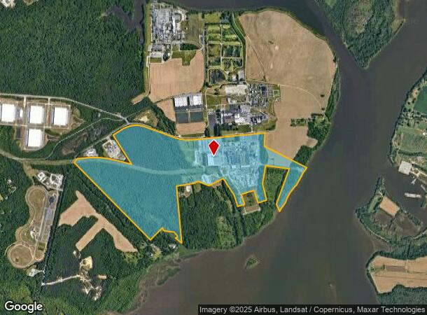
4101 Bermuda Hundred Rd
Richmond, VA
Bermuda Hundred Parcel 1
835-64-88-68-600-000
BERMUDA HUNDRED PARCEL 1
Heavymanufacturing
Chesterfield
A
Virginia
51041C0360E
356.70 AC
0
I-95 S/I-295 S/Rt 10
2025
Richmond VA
100403
DEMOGRAPHICS near 4101 Bermuda Hundred Rd
1 Mile
3 Mile
5 Mile
2024 Total Population
44
10,642
42,147
2029 Population
51
11,185
43,663
Pop Growth 2024-2029
+ 15.91%
+ 5.10%
+ 3.60%
Average Age
39
39
40
2024 Total Households
14
4,323
14,837
HH Growth 2024-2029
+ 14.29%
+ 4.67%
+ 3.63%
Median Household Inc
$87,500
$54,986
$64,127
Avg Household Size
2.60
2.40
2.50
2024 Avg HH Vehicles
3.00
2.00
2.00
Median Home Value
$541,667
$216,396
$218,279
Median Year Built
2010
1969
1978
Nearby Places
Map Layers
Map Styles
 Street
 Aerial
- Restaurants
- Banks
- Shops
- Fitness
- Groceries
PUBLIC TRANSPORTATION
AIRPORT
Richmond International
DRIVE
WALK
Distance
Richmond International
36 min
21.0 mi
Freight Ports
Virginia Port Authority - Richmond
DRIVE
WALK
Distance
Virginia Port Authority - Richmond
33 min
18.0 mi
Nearby Properties
Address
Land Use
TOTAL SIZE
Lot Size
Zoning
Address
Land Use
TOTAL SIZE
Lot Size
Zoning
99.30 AC
I2 - GEN I
Address
Land Use
TOTAL SIZE
Lot Size
Zoning
252,000 SF
118.66 AC
I3 - HVY I
Address
Land Use
TOTAL SIZE
Lot Size
Zoning
164.03 AC
M2
Address
Land Use
TOTAL SIZE
Lot Size
Zoning
137.06 AC
M2
Address
Land Use
TOTAL SIZE
Lot Size
Zoning
557,533 SF
48.60 AC
I2 - GEN I
Address
Land Use
TOTAL SIZE
Lot Size
Zoning
41,930 SF
23.04 AC
C5 - GEN B
Address
Land Use
TOTAL SIZE
Lot Size
Zoning
352,800 SF
54.30 AC
I2 - GEN I
Address
Land Use
TOTAL SIZE
Lot Size
Zoning
459.55 AC
I3 - HVY I
Address
Land Use
TOTAL SIZE
Lot Size
Zoning
100 SF
14.70 AC
C5 - GEN B
Address
Land Use
TOTAL SIZE
Lot Size
Zoning
404,200 SF
62.22 AC
I2 - GEN I
Address
Land Use
TOTAL SIZE
Lot Size
Zoning
242,042 SF
10.15 AC
I2 - GEN I
Address
Land Use
TOTAL SIZE
Lot Size
Zoning
91,105 SF
10.90 AC
C3 - COMMU
Address
Land Use
TOTAL SIZE
Lot Size
Zoning
13.70 AC
B2
Address
Land Use
TOTAL SIZE
Lot Size
Zoning
219 SF
74.95 AC
I3 - HVY I
Address
Land Use
TOTAL SIZE
Lot Size
Zoning
228,108 SF
19.32 AC
I1 - LT IN
Address
Land Use
TOTAL SIZE
Lot Size
Zoning
35,173 SF
19.30 AC
C3 - COMMU
Address
Land Use
TOTAL SIZE
Lot Size
Zoning
120 SF
100.80 AC
I3 - HVY I
Address
Land Use
TOTAL SIZE
Lot Size
Zoning
170,800 SF
13.74 AC
I1 - LT IN
Address
Land Use
TOTAL SIZE
Lot Size
Zoning
296.90 AC
I3 - HVY I
Address
Land Use
TOTAL SIZE
Lot Size
Zoning
124.99 AC
I2 - GEN I
Address
Land Use
TOTAL SIZE
Lot Size
Zoning
136,644 SF
13.24 AC
I3 - HVY I
Address
Land Use
TOTAL SIZE
Lot Size
Zoning
8,000 SF
52.80 AC
M2
Address
Land Use
TOTAL SIZE
Lot Size
Zoning
35,224 SF
3.87 AC
B1
Address
Land Use
TOTAL SIZE
Lot Size
Zoning
11,250 SF
7.36 AC
M2
Address
Land Use
TOTAL SIZE
Lot Size
Zoning
196.75 AC
A - AGRICU
Address
Land Use
TOTAL SIZE
Lot Size
Zoning
45,515 SF
4.28 AC
B2
Address
Land Use
TOTAL SIZE
Lot Size
Zoning
107.38 AC
M2
Address
Land Use
TOTAL SIZE
Lot Size
Zoning
0.25 AC
B1
Address
Land Use
TOTAL SIZE
Lot Size
Zoning
59,850 SF
3.33 AC
C5 - GEN B
The World's #1 Commercial Real Estate Marketplace
Connect with us
© 2026 CoStar Group
The information above has been obtained from sources believed reliable. While we do not doubt its accuracy we have not verified it and make no guarantee, warranty or representation about it. It is your responsibility to independently confirm its accuracy and completeness. Any projections, opinions, assumptions, or estimates used are for example only and do not represent the current or future performance of the property. The value of this transaction to you depends on tax and other factors which should be evaluated by your tax, financial, and legal advisors. You and your advisors should conduct a careful, independent investigation of the property to determine to your satisfaction the suitability of the property for your needs.