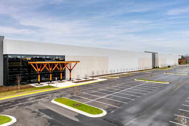
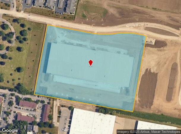
Property Record
4101 Canterfield Pkwy E, West Dundee, IL 60118
NEARBY LISTINGS FOR SALE OR LEASE
Property Detail
4101 Canterfield Pkwy E
Chicago
Canterfield Corporate Campus Sub
Chicago-Naperville-Elgin, IL-IN-WI
CANTERFIELD CORPORATE CAMPUS SUB LT 1
03-34-251-001
Kane
Industrialgeneral
Illinois
2024
1
2024
North Kane/I-90
DEMOGRAPHICS near 4101 Canterfield Pkwy E
1 Mile
3 Mile
5 Mile
2024 Total Population
3,021
73,846
170,377
2029 Population
3,027
73,413
168,954
Pop Growth 2024-2029
+ 0.20%
(0.59%)
(0.84%)
Average Age
43
39
38
2024 Total Households
1,294
26,536
56,784
HH Growth 2024-2029
+ 0.23%
(0.68%)
(0.94%)
Median Household Inc
$71,169
$78,993
$82,672
Avg Household Size
2.10
2.70
2.90
2024 Avg HH Vehicles
2.00
2.00
2.00
Median Home Value
$173,499
$232,748
$235,823
Median Year Built
1977
1972
1976
Nearby Places
Map Layers
Map Styles
 Street
 Aerial
- Restaurants
- Banks
- Shops
- Fitness
- Groceries
PUBLIC TRANSPORTATION
COMMUTER RAIL
Elgin Station (Milwaukee District West Line - Northeast Illinois Regional Commuter Railroad (Metra))
DRIVE
WALK
Distance
Elgin Station (Milwaukee District West Line - Northeast Illinois Regional Commuter Railroad (Metra))
8 min
3.2 mi
Big Timber Road Station (Milwaukee District West Line - Northeast Illinois Regional Commuter Railroad (Metra))
DRIVE
WALK
Distance
Big Timber Road Station (Milwaukee District West Line - Northeast Illinois Regional Commuter Railroad (Metra))
8 min
3.4 mi
AIRPORT
Chicago O'Hare International
DRIVE
WALK
Distance
Chicago O'Hare International
34 min
26.9 mi
Freight Ports
Port Milwaukee
DRIVE
WALK
Distance
Port Milwaukee
112 min
81.3 mi
SALE & LEASE HISTORY
LISTING DATE
SALE/LEASE

Oct 24, 2022
For Lease
Nearby Properties
Address
Land Use
TOTAL SIZE
Lot Size
Zoning
Address
Land Use
TOTAL SIZE
Lot Size
Zoning
551,248 SF
28.94 AC
Address
Land Use
TOTAL SIZE
Lot Size
Zoning
61.92 AC
Address
Land Use
TOTAL SIZE
Lot Size
Zoning
23.54 AC
Address
Land Use
TOTAL SIZE
Lot Size
Zoning
27.33 AC
Address
Land Use
TOTAL SIZE
Lot Size
Zoning
108.60 AC
Address
Land Use
TOTAL SIZE
Lot Size
Zoning
20.93 AC
Address
Land Use
TOTAL SIZE
Lot Size
Zoning
431,318 SF
20 AC
Address
Land Use
TOTAL SIZE
Lot Size
Zoning
522,133 SF
16 AC
Address
Land Use
TOTAL SIZE
Lot Size
Zoning
Address
Land Use
TOTAL SIZE
Lot Size
Zoning
99,800 SF
0.53 AC
Address
Land Use
TOTAL SIZE
Lot Size
Zoning
211,680 SF
11.60 AC
Address
Land Use
TOTAL SIZE
Lot Size
Zoning
211,680 SF
11.34 AC
Address
Land Use
TOTAL SIZE
Lot Size
Zoning
35,808 SF
11.40 AC
Address
Land Use
TOTAL SIZE
Lot Size
Zoning
7,254 SF
1.98 AC
Address
Land Use
TOTAL SIZE
Lot Size
Zoning
Address
Land Use
TOTAL SIZE
Lot Size
Zoning
176,799 SF
10 AC
Address
Land Use
TOTAL SIZE
Lot Size
Zoning
193,288 SF
16.24 AC
Address
Land Use
TOTAL SIZE
Lot Size
Zoning
5.03 AC
Address
Land Use
TOTAL SIZE
Lot Size
Zoning
99,903 SF
6.49 AC
Address
Land Use
TOTAL SIZE
Lot Size
Zoning
10.03 AC
Address
Land Use
TOTAL SIZE
Lot Size
Zoning
179,857 SF
4.60 AC
Address
Land Use
TOTAL SIZE
Lot Size
Zoning
54,000 SF
6.56 AC
Address
Land Use
TOTAL SIZE
Lot Size
Zoning
54,000 SF
7.65 AC
Address
Land Use
TOTAL SIZE
Lot Size
Zoning
130,050 SF
12.64 AC
Address
Land Use
TOTAL SIZE
Lot Size
Zoning
Address
Land Use
TOTAL SIZE
Lot Size
Zoning
71,725 SF
49.30 AC
Address
Land Use
TOTAL SIZE
Lot Size
Zoning
154,483 SF
10 AC
Address
Land Use
TOTAL SIZE
Lot Size
Zoning
The World's #1 Commercial Real Estate Marketplace
Connect with us
© 2025 CoStar Group
The information above has been obtained from sources believed reliable. While we do not doubt its accuracy we have not verified it and make no guarantee, warranty or representation about it. It is your responsibility to independently confirm its accuracy and completeness. Any projections, opinions, assumptions, or estimates used are for example only and do not represent the current or future performance of the property. The value of this transaction to you depends on tax and other factors which should be evaluated by your tax, financial, and legal advisors. You and your advisors should conduct a careful, independent investigation of the property to determine to your satisfaction the suitability of the property for your needs.