Property Record
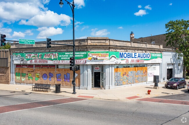
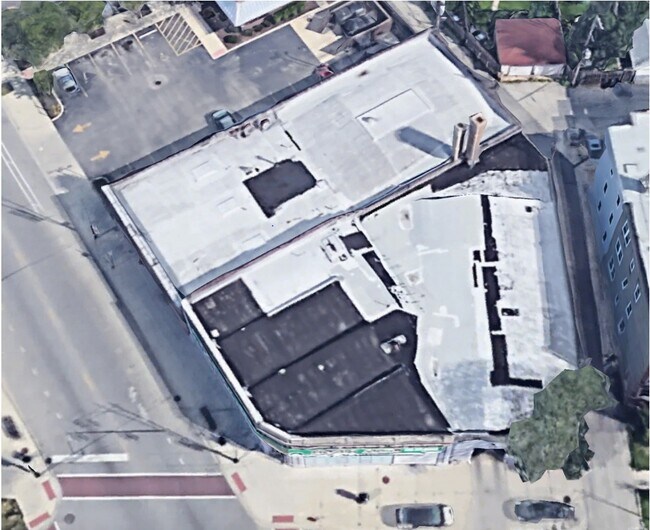
4107 N Milwaukee Ave, Chicago, IL 60641
This Property Is For Sale
NEARBY LISTINGS FOR SALE OR LEASE
Property Detail
4107 N Milwaukee Ave
Commercialbuilding
Cook
X
Illinois
17031C0403J
0.14 AC
2023
Northwest City
2024
Chicago
150200
Chicago-Naperville-Elgin, IL-IN-WI
6,211 SF
13-16-423-007-0000
DEMOGRAPHICS near 4107 N Milwaukee Ave
1 Mile
3 Mile
5 Mile
2024 Total Population
37,621
361,498
963,527
2029 Population
35,266
338,874
915,298
Pop Growth 2024-2029
(6.26%)
(6.26%)
(5.01%)
Average Age
39
39
39
2024 Total Households
14,591
131,284
375,434
HH Growth 2024-2029
(6.57%)
(6.56%)
(5.23%)
Median Household Inc
$80,516
$74,778
$79,246
Avg Household Size
2.50
2.60
2.50
2024 Avg HH Vehicles
2.00
1.00
1.00
Median Home Value
$364,087
$347,753
$369,615
Median Year Built
1946
1947
1948
Nearby Places
Map Layers
Map Styles
 Street
 Aerial
- Restaurants
- Banks
- Shops
- Fitness
- Groceries
PUBLIC TRANSPORTATION
TRANSIT/SUBWAY
Montrose Station (Blue Line) (Blue Line - Chicago Transit Authority "L" Trains (The "L"))
DRIVE
WALK
Distance
Montrose Station (Blue Line) (Blue Line - Chicago Transit Authority "L" Trains (The "L"))
3 min
16 min
0.8 mi
COMMUTER RAIL
Mayfair Station (Milwaukee District North Line - Northeast Illinois Regional Commuter Railroad (Metra))
DRIVE
WALK
Distance
Mayfair Station (Milwaukee District North Line - Northeast Illinois Regional Commuter Railroad (Metra))
1 min
10 min
0.6 mi
Grayland Station (Milwaukee District North Line - Northeast Illinois Regional Commuter Railroad (Metra))
DRIVE
WALK
Distance
Grayland Station (Milwaukee District North Line - Northeast Illinois Regional Commuter Railroad (Metra))
1 min
14 min
0.7 mi
AIRPORT
Chicago O'Hare International
DRIVE
WALK
Distance
Chicago O'Hare International
16 min
9.3 mi
Chicago Midway International
DRIVE
WALK
Distance
Chicago Midway International
25 min
13.5 mi
Freight Ports
Port Milwaukee
DRIVE
WALK
Distance
Port Milwaukee
95 min
78.1 mi
Nearby Properties
Address
Land Use
TOTAL SIZE
Lot Size
Zoning
Address
Land Use
TOTAL SIZE
Lot Size
Zoning
Address
Land Use
TOTAL SIZE
Lot Size
Zoning
192,365 SF
21.34 AC
PD 127
Address
Land Use
TOTAL SIZE
Lot Size
Zoning
21.56 AC
RS-2
Address
Land Use
TOTAL SIZE
Lot Size
Zoning
PD 184
Address
Land Use
TOTAL SIZE
Lot Size
Zoning
237,832 SF
14.04 AC
PD 418
Address
Land Use
TOTAL SIZE
Lot Size
Zoning
190,011 SF
5.90 AC
PD 353
Address
Land Use
TOTAL SIZE
Lot Size
Zoning
170,538 SF
0.76 AC
PD 112
Address
Land Use
TOTAL SIZE
Lot Size
Zoning
331,294 SF
13.03 AC
PD 439
Address
Land Use
TOTAL SIZE
Lot Size
Zoning
1.04 AC
PD 130
Address
Land Use
TOTAL SIZE
Lot Size
Zoning
201,600 SF
1.93 AC
PD 92
Address
Land Use
TOTAL SIZE
Lot Size
Zoning
139.71 AC
PD 184
Address
Land Use
TOTAL SIZE
Lot Size
Zoning
6.31 AC
PD 1013
Address
Land Use
TOTAL SIZE
Lot Size
Zoning
15,600 SF
0.77 AC
M1-1
Address
Land Use
TOTAL SIZE
Lot Size
Zoning
3.33 AC
PD 1013
Address
Land Use
TOTAL SIZE
Lot Size
Zoning
100,900 SF
4.85 AC
PD 1415
Address
Land Use
TOTAL SIZE
Lot Size
Zoning
340,838 SF
31 AC
PD 1411
Address
Land Use
TOTAL SIZE
Lot Size
Zoning
382,635 SF
5.90 AC
M1-1
Address
Land Use
TOTAL SIZE
Lot Size
Zoning
13.33 AC
PD 127
Address
Land Use
TOTAL SIZE
Lot Size
Zoning
78,410 SF
4.87 AC
PD 171
Address
Land Use
TOTAL SIZE
Lot Size
Zoning
0.43 AC
RS-2
Address
Land Use
TOTAL SIZE
Lot Size
Zoning
67,588 SF
2.50 AC
PD 415
Address
Land Use
TOTAL SIZE
Lot Size
Zoning
277,819 SF
10.58 AC
PD 127
Address
Land Use
TOTAL SIZE
Lot Size
Zoning
141,095 SF
9.15 AC
PD 127
Address
Land Use
TOTAL SIZE
Lot Size
Zoning
83,288 SF
13.43 AC
RT-4
Address
Land Use
TOTAL SIZE
Lot Size
Zoning
43,750 SF
1.19 AC
B1-1
Address
Land Use
TOTAL SIZE
Lot Size
Zoning
68,831 SF
3.11 AC
PD 353
Address
Land Use
TOTAL SIZE
Lot Size
Zoning
92,380 SF
7.28 AC
RS-2
Address
Land Use
TOTAL SIZE
Lot Size
Zoning
1.20 AC
PD 92
Address
Land Use
TOTAL SIZE
Lot Size
Zoning
116,624 SF
6.16 AC
PD 439
Address
Land Use
TOTAL SIZE
Lot Size
Zoning
0.44 AC
RS-3
The World's #1 Commercial Real Estate Marketplace
Connect with us
© 2025 CoStar Group
The information above has been obtained from sources believed reliable. While we do not doubt its accuracy we have not verified it and make no guarantee, warranty or representation about it. It is your responsibility to independently confirm its accuracy and completeness. Any projections, opinions, assumptions, or estimates used are for example only and do not represent the current or future performance of the property. The value of this transaction to you depends on tax and other factors which should be evaluated by your tax, financial, and legal advisors. You and your advisors should conduct a careful, independent investigation of the property to determine to your satisfaction the suitability of the property for your needs.