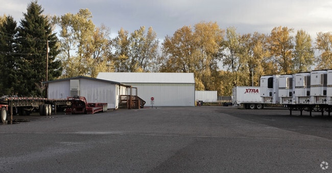
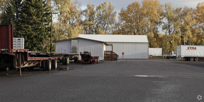
Property Record
4101 N Suttle Rd, Portland, OR 97217

Property Detail
4101 N Suttle Rd
R323403
SECTION 32 2N 1E, TL 400 7.09 ACRES
Industrialgeneral
Multnomah
IH
Oregon
AE The base floodplain where base flood elevations are provided. AE Zones are now used on new format FIRMs instead of A1-A30 Zones.
7.09 AC
2025
Rivergate
2025
Portland
007202
Portland-Vancouver-Hillsboro, OR-WA
5,400 SF
NEARBY LISTINGS FOR SALE OR LEASE
-
-
View all Portland listings for lease on LoopNet.com
DEMOGRAPHICS near 4101 N Suttle Rd
1 mile
3 mile
5 mile
2024 Total Population
397
64,829
164,702
2029 Population
395
64,974
166,359
Pop Growth 2024-2029
(0.50%)
+ 0.22%
+ 1.01%
Average Age
45
40
40
2024 Total Households
157
27,448
69,734
HH Growth 2024-2029
(0.64%)
+ 0.64%
+ 1.13%
Median Household Inc
$58,333
$81,417
$87,041
Avg Household Size
2.20
2.20
2.20
2024 Avg HH Vehicles
2.00
2.00
2.00
Median Home Value
$178,571
$490,660
$542,420
Median Year Built
1976
1968
1968
Nearby Places
Map Layers
Map Styles
 Street
 Aerial
Transit
 Traffic
 Biking
Places
Listings with unknown addresses are not visible on the map
- Restaurants
- Banks
- Shops
- Fitness
- Groceries
SALE & LEASE HISTORY
LISTING DATE
SALE/LEASE

Feb 07, 2018
For Lease
Nearby Properties
Address
Land Use
TOTAL SIZE
Lot Size
Zoning
Address
Land Use
TOTAL SIZE
Lot Size
Zoning
200,109 SF
70.44 AC
IH
Address
Land Use
TOTAL SIZE
Lot Size
Zoning
546,069 SF
142 AC
IH
Address
Land Use
TOTAL SIZE
Lot Size
Zoning
332,800 SF
12.78 AC
IH
Address
Land Use
TOTAL SIZE
Lot Size
Zoning
522,778 SF
193.16 AC
CPX
Address
Land Use
TOTAL SIZE
Lot Size
Zoning
437,419 SF
37.90 AC
IG2
Address
Land Use
TOTAL SIZE
Lot Size
Zoning
465,188 SF
1.29 AC
CX
Address
Land Use
TOTAL SIZE
Lot Size
Zoning
769,347 SF
8.52 AC
CX
Address
Land Use
TOTAL SIZE
Lot Size
Zoning
262,045 SF
17.10 AC
R5
Address
Land Use
TOTAL SIZE
Lot Size
Zoning
490,802 SF
56.17 AC
CGX
Address
Land Use
TOTAL SIZE
Lot Size
Zoning
335,004 SF
17.06 AC
IL
Address
Land Use
TOTAL SIZE
Lot Size
Zoning
335.31 AC
OS
Address
Land Use
TOTAL SIZE
Lot Size
Zoning
1,660,710 SF
110.33 AC
IG2
Address
Land Use
TOTAL SIZE
Lot Size
Zoning
463,000 SF
67.68 AC
CPX
Address
Land Use
TOTAL SIZE
Lot Size
Zoning
589,596 SF
9.63 AC
R-22
Address
Land Use
TOTAL SIZE
Lot Size
Zoning
278,788 SF
0.92 AC
CX
Address
Land Use
TOTAL SIZE
Lot Size
Zoning
5,045,000 SF
116.53 AC
IH
Address
Land Use
TOTAL SIZE
Lot Size
Zoning
307,468 SF
8.27 AC
CPX
Address
Land Use
TOTAL SIZE
Lot Size
Zoning
352,560 SF
18.34 AC
IL
Address
Land Use
TOTAL SIZE
Lot Size
Zoning
294,114 SF
2.03 AC
CX
Address
Land Use
TOTAL SIZE
Lot Size
Zoning
222,177 SF
4.96 AC
CX
Address
Land Use
TOTAL SIZE
Lot Size
Zoning
18,135 SF
0.45 AC
CX
Address
Land Use
TOTAL SIZE
Lot Size
Zoning
258,882 SF
15.50 AC
IL
Address
Land Use
TOTAL SIZE
Lot Size
Zoning
294,955 SF
14.10 AC
IL
Address
Land Use
TOTAL SIZE
Lot Size
Zoning
361,120 SF
20 AC
IH
Address
Land Use
TOTAL SIZE
Lot Size
Zoning
5.19 AC
IH
Address
Land Use
TOTAL SIZE
Lot Size
Zoning
73,657 SF
1.90 AC
CI1
Address
Land Use
TOTAL SIZE
Lot Size
Zoning
253,011 SF
0.98 AC
CX
Address
Land Use
TOTAL SIZE
Lot Size
Zoning
127,050 SF
1.23 AC
CX
Address
Land Use
TOTAL SIZE
Lot Size
Zoning
192,958 SF
10.28 AC
IL
Address
Land Use
TOTAL SIZE
Lot Size
Zoning
200 SF
50.40 AC
IH
The World's #1 Commercial Real Estate Marketplace
Connect with us
© 2026 CoStar Group
The information above has been obtained from sources believed reliable. While we do not doubt its accuracy we have not verified it and make no guarantee, warranty or representation about it. It is your responsibility to independently confirm its accuracy and completeness. Any projections, opinions, assumptions, or estimates used are for example only and do not represent the current or future performance of the property. The value of this transaction to you depends on tax and other factors which should be evaluated by your tax, financial, and legal advisors. You and your advisors should conduct a careful, independent investigation of the property to determine to your satisfaction the suitability of the property for your needs.