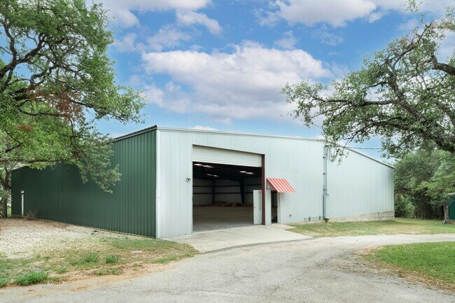
Property Record
4101 W State Highway 29, Georgetown, TX 78628


Property Detail
4101 W State Highway 29
R039224
AW0178 AW0178 - DONAGAN, I. SUR., ACRES 3.65
Commercialnec
Williamson
B and X Area of moderate flood hazard, usually the area between the limits of the 100-year and 500-year floods.
Texas
2024
3.65 AC
2025
Georgetown
020124
Austin
17,032 SF
Austin-Round Rock-San Marcos, TX
NEARBY LISTINGS FOR SALE OR LEASE
DEMOGRAPHICS near 4101 W State Highway 29
1 mile
3 mile
5 mile
2025 Total Population
1,991
14,394
77,637
2030 Population
2,465
17,458
91,342
Pop Growth 2025-2030
+ 23.81%
+ 21.29%
+ 17.65%
Average Age
45
42
41
2025 Total Households
760
5,490
29,834
HH Growth 2025-2030
+ 23.95%
+ 21.57%
+ 18.02%
Median Household Inc
$163,292
$171,848
$130,928
Avg Household Size
2.60
2.60
2.60
2025 Avg HH Vehicles
2.00
2.00
2.00
Median Home Value
$464,444
$676,223
$580,709
Median Year Built
2011
2011
2010
Nearby Places
Map Layers
Map Styles
 Street
 Aerial
Transit
 Traffic
 Biking
Places
Listings with unknown addresses are not visible on the map
- Restaurants
- Banks
- Shops
- Fitness
- Groceries
PUBLIC TRANSPORTATION
AIRPORT
Austin-Bergstrom International
Drive
Walk
Distance
Austin-Bergstrom International
56 min
41.0 mi
Robert Gray AAF
Drive
Walk
Distance
Robert Gray AAF
63 min
41.7 mi
Killeen Municipal
Drive
Walk
Distance
Killeen Municipal
59 min
45.1 mi
SALE & LEASE HISTORY
LISTING DATE
SALE/LEASE

Sep 30, 2019
For Lease
Sep 30, 2019
For Sale
May 19, 2021
For Lease
May 01, 2023
For Lease
Mar 09, 2018
For Lease
Mar 08, 2018
For Sale
Nearby Properties
Address
Land Use
TOTAL SIZE
Lot Size
Zoning
Address
Land Use
TOTAL SIZE
Lot Size
Zoning
393,202 SF
15.42 AC
Address
Land Use
TOTAL SIZE
Lot Size
Zoning
272,531 SF
14.97 AC
Address
Land Use
TOTAL SIZE
Lot Size
Zoning
124,652 SF
14.96 AC
Address
Land Use
TOTAL SIZE
Lot Size
Zoning
148,228 SF
21.32 AC
Address
Land Use
TOTAL SIZE
Lot Size
Zoning
2,086 SF
25.66 AC
Address
Land Use
TOTAL SIZE
Lot Size
Zoning
40,042 SF
19.78 AC
Address
Land Use
TOTAL SIZE
Lot Size
Zoning
53,794 SF
19.77 AC
Address
Land Use
TOTAL SIZE
Lot Size
Zoning
125,929 SF
2.18 AC
Address
Land Use
TOTAL SIZE
Lot Size
Zoning
Address
Land Use
TOTAL SIZE
Lot Size
Zoning
72,199 SF
7.85 AC
Address
Land Use
TOTAL SIZE
Lot Size
Zoning
20,206 SF
18.52 AC
Address
Land Use
TOTAL SIZE
Lot Size
Zoning
32,092 SF
0.14 AC
Address
Land Use
TOTAL SIZE
Lot Size
Zoning
61,130 SF
7.71 AC
Address
Land Use
TOTAL SIZE
Lot Size
Zoning
89.42 AC
Address
Land Use
TOTAL SIZE
Lot Size
Zoning
1,508 SF
7.01 AC
Address
Land Use
TOTAL SIZE
Lot Size
Zoning
3,237 SF
81.23 AC
Address
Land Use
TOTAL SIZE
Lot Size
Zoning
7,180 SF
4.72 AC
Address
Land Use
TOTAL SIZE
Lot Size
Zoning
13,710 SF
3.65 AC
Address
Land Use
TOTAL SIZE
Lot Size
Zoning
4,698 SF
1.50 AC
Address
Land Use
TOTAL SIZE
Lot Size
Zoning
32,092 SF
14.05 AC
Address
Land Use
TOTAL SIZE
Lot Size
Zoning
17,426 SF
2.46 AC
Address
Land Use
TOTAL SIZE
Lot Size
Zoning
10.02 AC
Address
Land Use
TOTAL SIZE
Lot Size
Zoning
Address
Land Use
TOTAL SIZE
Lot Size
Zoning
Address
Land Use
TOTAL SIZE
Lot Size
Zoning
Address
Land Use
TOTAL SIZE
Lot Size
Zoning
45.29 AC
Address
Land Use
TOTAL SIZE
Lot Size
Zoning
2,393 SF
28.22 AC
Address
Land Use
TOTAL SIZE
Lot Size
Zoning
1,017 SF
56.35 AC
Address
Land Use
TOTAL SIZE
Lot Size
Zoning
The World's #1 Commercial Real Estate Marketplace
Connect with us
© 2026 CoStar Group
The information above has been obtained from sources believed reliable. While we do not doubt its accuracy we have not verified it and make no guarantee, warranty or representation about it. It is your responsibility to independently confirm its accuracy and completeness. Any projections, opinions, assumptions, or estimates used are for example only and do not represent the current or future performance of the property. The value of this transaction to you depends on tax and other factors which should be evaluated by your tax, financial, and legal advisors. You and your advisors should conduct a careful, independent investigation of the property to determine to your satisfaction the suitability of the property for your needs.