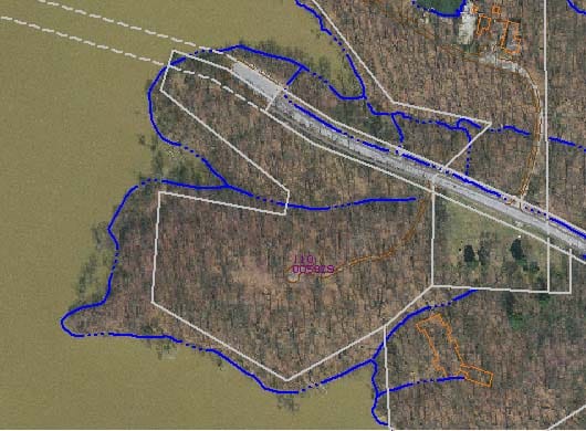
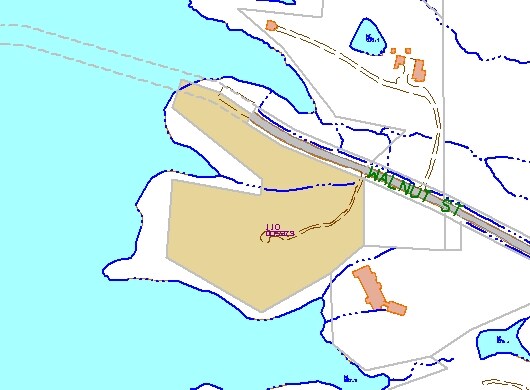
Property Record
4102 E Walnut St, Westerville, OH 43081

Property Detail
4102 E Walnut St
Columbus, OH
4102 WALNUT ST R17 T2 1/4T1 3.022 ACRES
110-005929
FRANKLIN
Recreationalacreage
Ohio
2024
3.02 AC
2025
Westerville
010000
Columbus
NEARBY LISTINGS FOR SALE OR LEASE
DEMOGRAPHICS near 4102 E Walnut St
1 mile
3 mile
5 mile
2025 Total Population
2,567
68,682
170,336
2030 Population
2,655
71,573
177,008
Pop Growth 2025-2030
+ 3.43%
+ 4.21%
+ 3.92%
Average Age
44
41
40
2025 Total Households
990
29,493
70,184
HH Growth 2025-2030
+ 3.74%
+ 4.31%
+ 4.01%
Median Household Inc
$122,147
$96,890
$94,524
Avg Household Size
2.50
2.30
2.40
2025 Avg HH Vehicles
2.00
2.00
2.00
Median Home Value
$409,743
$364,339
$360,683
Median Year Built
1983
1994
1993
Nearby Places
Map Layers
Map Styles
 Street
 Aerial
Layers
 Traffic
 Biking
Places
Listings with unknown addresses are not visible on the map
- Restaurants
- Banks
- Shops
- Fitness
- Groceries
PUBLIC TRANSPORTATION
AIRPORT
John Glenn Columbus International
Drive
Walk
Distance
John Glenn Columbus International
20 min
11.6 mi
Rickenbacker International
Drive
Walk
Distance
Rickenbacker International
38 min
25.7 mi
Freight Ports
Port of Toledo
Drive
Walk
Distance
Port of Toledo
182 min
144.2 mi
Nearby Properties
Address
Land Use
TOTAL SIZE
Lot Size
Zoning
Address
Land Use
TOTAL SIZE
Lot Size
Zoning
253,127 SF
31.59 AC
Address
Land Use
TOTAL SIZE
Lot Size
Zoning
112,126 SF
19.09 AC
Address
Land Use
TOTAL SIZE
Lot Size
Zoning
446,516 SF
95.88 AC
Address
Land Use
TOTAL SIZE
Lot Size
Zoning
602,448 SF
24.71 AC
Address
Land Use
TOTAL SIZE
Lot Size
Zoning
320,022 SF
37.14 AC
Address
Land Use
TOTAL SIZE
Lot Size
Zoning
45,135 SF
22.02 AC
Address
Land Use
TOTAL SIZE
Lot Size
Zoning
132,276 SF
0.18 AC
Address
Land Use
TOTAL SIZE
Lot Size
Zoning
62,660 SF
41.24 AC
Address
Land Use
TOTAL SIZE
Lot Size
Zoning
180,968 SF
12.77 AC
Address
Land Use
TOTAL SIZE
Lot Size
Zoning
3,263 SF
989.66 AC
Address
Land Use
TOTAL SIZE
Lot Size
Zoning
74,620 SF
9.03 AC
Address
Land Use
TOTAL SIZE
Lot Size
Zoning
45,849 SF
29.64 AC
Address
Land Use
TOTAL SIZE
Lot Size
Zoning
292,377 SF
36.29 AC
Address
Land Use
TOTAL SIZE
Lot Size
Zoning
144,900 SF
11.04 AC
Address
Land Use
TOTAL SIZE
Lot Size
Zoning
151,892 SF
8.63 AC
Address
Land Use
TOTAL SIZE
Lot Size
Zoning
151,935 SF
9 AC
Address
Land Use
TOTAL SIZE
Lot Size
Zoning
76,096 SF
16.41 AC
Address
Land Use
TOTAL SIZE
Lot Size
Zoning
51,376 SF
12.65 AC
Address
Land Use
TOTAL SIZE
Lot Size
Zoning
236,681 SF
7.83 AC
Address
Land Use
TOTAL SIZE
Lot Size
Zoning
25,208 SF
25.95 AC
Address
Land Use
TOTAL SIZE
Lot Size
Zoning
96,086 SF
12.23 AC
Address
Land Use
TOTAL SIZE
Lot Size
Zoning
89,544 SF
4.82 AC
Address
Land Use
TOTAL SIZE
Lot Size
Zoning
133,524 SF
10.15 AC
Address
Land Use
TOTAL SIZE
Lot Size
Zoning
61,326 SF
15.78 AC
Address
Land Use
TOTAL SIZE
Lot Size
Zoning
46,080 SF
13.23 AC
Address
Land Use
TOTAL SIZE
Lot Size
Zoning
175,042 SF
8.10 AC
Address
Land Use
TOTAL SIZE
Lot Size
Zoning
189,276 SF
16.25 AC
Address
Land Use
TOTAL SIZE
Lot Size
Zoning
77,831 SF
7.92 AC
Address
Land Use
TOTAL SIZE
Lot Size
Zoning
87,320 SF
3.73 AC
Address
Land Use
TOTAL SIZE
Lot Size
Zoning
43,260 SF
4.11 AC
The World's #1 Commercial Real Estate Marketplace
Connect with us
© 2026 CoStar Group
The information above has been obtained from sources believed reliable. While we do not doubt its accuracy we have not verified it and make no guarantee, warranty or representation about it. It is your responsibility to independently confirm its accuracy and completeness. Any projections, opinions, assumptions, or estimates used are for example only and do not represent the current or future performance of the property. The value of this transaction to you depends on tax and other factors which should be evaluated by your tax, financial, and legal advisors. You and your advisors should conduct a careful, independent investigation of the property to determine to your satisfaction the suitability of the property for your needs.