Property Record
4102 N Council Rd, Bethany, OK 73008
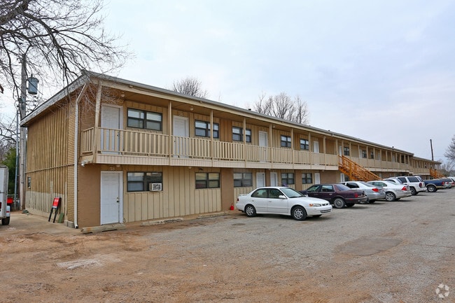


Property Detail
4102 N Council Rd
Oklahoma City, OK
SCHAFERS SUBURBS ADD 000 000 S80FT OF LOTS 15 & 16
177363750
Oklahoma
Multifamilydwelling
Oklahoma
B and X Area of moderate flood hazard, usually the area between the limits of the 100-year and 500-year floods.
15,16
2024
1.15 AC
2025
West Oklahoma City
106704
Oklahoma City
15,602 SF
NEARBY LISTINGS FOR SALE OR LEASE
-
-
View all Bethany listings for sale on LoopNet.com
DEMOGRAPHICS near 4102 N Council Rd
1 mile
3 mile
5 mile
2025 Total Population
5,140
79,613
185,643
2030 Population
5,225
82,825
194,317
Pop Growth 2025-2030
+ 1.65%
+ 4.03%
+ 4.67%
Average Age
41
37
38
2025 Total Households
2,031
31,117
74,175
HH Growth 2025-2030
+ 1.82%
+ 4.08%
+ 4.40%
Median Household Inc
$67,680
$53,693
$62,185
Avg Household Size
2.40
2.40
2.40
2025 Avg HH Vehicles
2.00
2.00
2.00
Median Home Value
$251,994
$205,682
$214,514
Median Year Built
1967
1972
1974
Nearby Places
Map Layers
Map Styles
 Street
 Aerial
Layers
 Traffic
 Biking
Places
Listings with unknown addresses are not visible on the map
- Restaurants
- Banks
- Shops
- Fitness
- Groceries
PUBLIC TRANSPORTATION
AIRPORT
Will Rogers World
Drive
Walk
Distance
Will Rogers World
25 min
12.2 mi
Nearby Properties
Address
Land Use
TOTAL SIZE
Lot Size
Zoning
Address
Land Use
TOTAL SIZE
Lot Size
Zoning
334,227 SF
18.01 AC
Address
Land Use
TOTAL SIZE
Lot Size
Zoning
44,519 SF
3.39 AC
SPUD
Address
Land Use
TOTAL SIZE
Lot Size
Zoning
144,735 SF
28 AC
Address
Land Use
TOTAL SIZE
Lot Size
Zoning
213,085 SF
3.64 AC
Address
Land Use
TOTAL SIZE
Lot Size
Zoning
641,860 SF
62.12 AC
R-4
Address
Land Use
TOTAL SIZE
Lot Size
Zoning
294,820 SF
12.17 AC
Address
Land Use
TOTAL SIZE
Lot Size
Zoning
342,342 SF
27.20 AC
R-4
Address
Land Use
TOTAL SIZE
Lot Size
Zoning
245,768 SF
15.93 AC
Address
Land Use
TOTAL SIZE
Lot Size
Zoning
199,832 SF
9.72 AC
PUD
Address
Land Use
TOTAL SIZE
Lot Size
Zoning
182,590 SF
11.35 AC
R-4
Address
Land Use
TOTAL SIZE
Lot Size
Zoning
172,368 SF
10.72 AC
R-4
Address
Land Use
TOTAL SIZE
Lot Size
Zoning
103,930 SF
10.20 AC
Address
Land Use
TOTAL SIZE
Lot Size
Zoning
182,948 SF
10 AC
Address
Land Use
TOTAL SIZE
Lot Size
Zoning
43,498 SF
3.28 AC
Address
Land Use
TOTAL SIZE
Lot Size
Zoning
217,512 SF
8.79 AC
C-3
Address
Land Use
TOTAL SIZE
Lot Size
Zoning
259,024 SF
14.16 AC
R-4
Address
Land Use
TOTAL SIZE
Lot Size
Zoning
1,865 SF
32.08 AC
Address
Land Use
TOTAL SIZE
Lot Size
Zoning
117,869 SF
8.13 AC
Address
Land Use
TOTAL SIZE
Lot Size
Zoning
276,106 SF
18.37 AC
R-4
Address
Land Use
TOTAL SIZE
Lot Size
Zoning
156,016 SF
11.04 AC
PUD
Address
Land Use
TOTAL SIZE
Lot Size
Zoning
163,284 SF
6.76 AC
R-4
Address
Land Use
TOTAL SIZE
Lot Size
Zoning
19,050 SF
1.17 AC
C-3
Address
Land Use
TOTAL SIZE
Lot Size
Zoning
6,148 SF
2.50 AC
R-1
Address
Land Use
TOTAL SIZE
Lot Size
Zoning
122,292 SF
4.45 AC
Address
Land Use
TOTAL SIZE
Lot Size
Zoning
177,868 SF
6.79 AC
R-4
Address
Land Use
TOTAL SIZE
Lot Size
Zoning
156,654 SF
5.77 AC
R-4
Address
Land Use
TOTAL SIZE
Lot Size
Zoning
151,828 SF
14.60 AC
Address
Land Use
TOTAL SIZE
Lot Size
Zoning
10,706 SF
1 AC
Address
Land Use
TOTAL SIZE
Lot Size
Zoning
197,994 SF
9.11 AC
Address
Land Use
TOTAL SIZE
Lot Size
Zoning
40,428 SF
4.98 AC
SPUD
The World's #1 Commercial Real Estate Marketplace
Connect with us
© 2026 CoStar Group
The information above has been obtained from sources believed reliable. While we do not doubt its accuracy we have not verified it and make no guarantee, warranty or representation about it. It is your responsibility to independently confirm its accuracy and completeness. Any projections, opinions, assumptions, or estimates used are for example only and do not represent the current or future performance of the property. The value of this transaction to you depends on tax and other factors which should be evaluated by your tax, financial, and legal advisors. You and your advisors should conduct a careful, independent investigation of the property to determine to your satisfaction the suitability of the property for your needs.