Property Record
4103 Foundation Blvd, New Albany, IN 47150
NEARBY LISTINGS FOR SALE OR LEASE
Property Detail
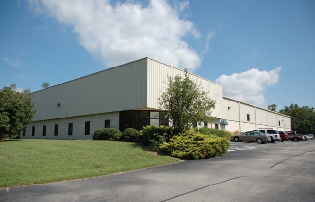
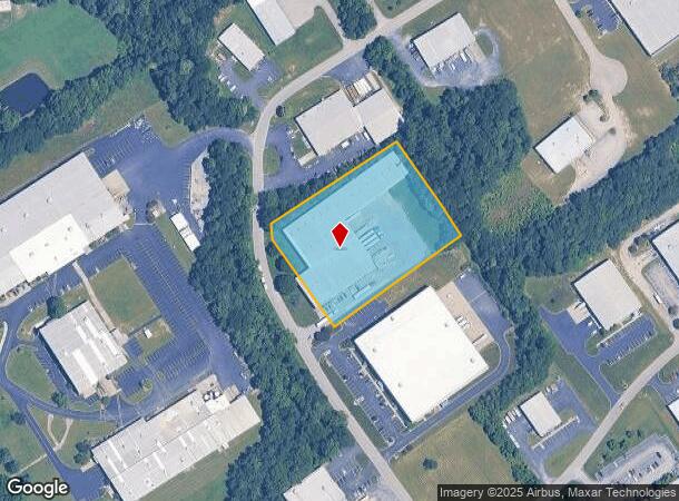
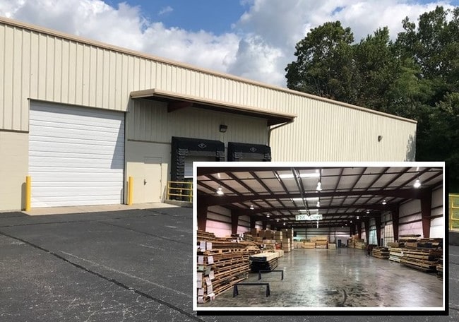
4103 Foundation Blvd
22-05-10-600-575.000-008
Grant Line Busn Park 1148
Warehouse
P 1148 TRACT #1 3.67AC MP 05-10-6B0-210.002
X
Floyd
18019C0256E
Indiana
2023
3.67 AC
2024
Outlying Floyd County
071007
Louisville
39,500 SF
Louisville-Jefferson County, KY-IN
DEMOGRAPHICS near 4103 Foundation Blvd
1 Mile
3 Mile
5 Mile
2024 Total Population
3,519
27,827
82,496
2029 Population
3,548
28,464
85,151
Pop Growth 2024-2029
+ 0.82%
+ 2.29%
+ 3.22%
Average Age
42
41
41
2024 Total Households
1,386
10,757
33,457
HH Growth 2024-2029
+ 0.72%
+ 2.24%
+ 3.21%
Median Household Inc
$78,436
$77,737
$61,469
Avg Household Size
2.50
2.50
2.40
2024 Avg HH Vehicles
2.00
2.00
2.00
Median Home Value
$227,397
$230,638
$182,659
Median Year Built
1994
1992
1978
Nearby Places
- Restaurants
- Banks
- Shops
- Fitness
- Groceries
PUBLIC TRANSPORTATION
AIRPORT
Louisville Muhammad Ali International
DRIVE
WALK
Distance
Louisville Muhammad Ali International
32 min
19.9 mi
Freight Ports
Port of Toledo
DRIVE
WALK
Distance
Port of Toledo
360 min
310.3 mi
SALE & LEASE HISTORY
LISTING DATE
SALE/LEASE

Mar 28, 2017
For Lease
Dec 21, 2017
For Lease
Aug 11, 2017
For Sale
Nearby Properties
Address
Land Use
TOTAL SIZE
Lot Size
Zoning
Address
Land Use
TOTAL SIZE
Lot Size
Zoning
27,360 SF
10.17 AC
Address
Land Use
TOTAL SIZE
Lot Size
Zoning
175,626 SF
60.10 AC
Address
Land Use
TOTAL SIZE
Lot Size
Zoning
21,540 SF
9.35 AC
Address
Land Use
TOTAL SIZE
Lot Size
Zoning
84,873 SF
15.71 AC
Address
Land Use
TOTAL SIZE
Lot Size
Zoning
11,695 SF
18.33 AC
Address
Land Use
TOTAL SIZE
Lot Size
Zoning
4,512 SF
17.76 AC
Address
Land Use
TOTAL SIZE
Lot Size
Zoning
1.84 AC
Address
Land Use
TOTAL SIZE
Lot Size
Zoning
270,377 SF
17.54 AC
Address
Land Use
TOTAL SIZE
Lot Size
Zoning
204,750 SF
26.96 AC
Address
Land Use
TOTAL SIZE
Lot Size
Zoning
58,884 SF
7.92 AC
Address
Land Use
TOTAL SIZE
Lot Size
Zoning
81,000 SF
44.74 AC
Address
Land Use
TOTAL SIZE
Lot Size
Zoning
43,204 SF
6.95 AC
Address
Land Use
TOTAL SIZE
Lot Size
Zoning
2,300 SF
15.14 AC
Address
Land Use
TOTAL SIZE
Lot Size
Zoning
27,039 SF
3.35 AC
Address
Land Use
TOTAL SIZE
Lot Size
Zoning
67,471 SF
7 AC
Address
Land Use
TOTAL SIZE
Lot Size
Zoning
80,812 SF
10.05 AC
Address
Land Use
TOTAL SIZE
Lot Size
Zoning
169 SF
35.25 AC
Address
Land Use
TOTAL SIZE
Lot Size
Zoning
3,760 SF
3.05 AC
Address
Land Use
TOTAL SIZE
Lot Size
Zoning
44,144 SF
6.26 AC
Address
Land Use
TOTAL SIZE
Lot Size
Zoning
17,572 SF
9.25 AC
Address
Land Use
TOTAL SIZE
Lot Size
Zoning
27,132 SF
4.27 AC
Address
Land Use
TOTAL SIZE
Lot Size
Zoning
56,496 SF
7.28 AC
Address
Land Use
TOTAL SIZE
Lot Size
Zoning
31,646 SF
5.63 AC
Address
Land Use
TOTAL SIZE
Lot Size
Zoning
21.12 AC
Address
Land Use
TOTAL SIZE
Lot Size
Zoning
3,360 SF
9.40 AC
Address
Land Use
TOTAL SIZE
Lot Size
Zoning
19,426 SF
3.97 AC
Address
Land Use
TOTAL SIZE
Lot Size
Zoning
13,712 SF
2 AC
Address
Land Use
TOTAL SIZE
Lot Size
Zoning
200,208 SF
10.66 AC
Address
Land Use
TOTAL SIZE
Lot Size
Zoning
101,806 SF
8.60 AC
Address
Land Use
TOTAL SIZE
Lot Size
Zoning
23,508 SF
1.99 AC
The World's #1 Commercial Real Estate Marketplace
Connect with us
© 2025 CoStar Group
The information above has been obtained from sources believed reliable. While we do not doubt its accuracy we have not verified it and make no guarantee, warranty or representation about it. It is your responsibility to independently confirm its accuracy and completeness. Any projections, opinions, assumptions, or estimates used are for example only and do not represent the current or future performance of the property. The value of this transaction to you depends on tax and other factors which should be evaluated by your tax, financial, and legal advisors. You and your advisors should conduct a careful, independent investigation of the property to determine to your satisfaction the suitability of the property for your needs.