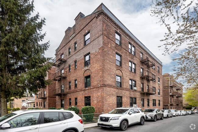
Property Record
4104 159Th St, Flushing, NY 11358


NEARBY LISTINGS FOR SALE OR LEASE
Property Detail
4104 159Th St
05331-0024
Queens
Multifamilydwelling
New York
X
24
3604970118F
0.23 AC
2024
Murray Hill
2025
Long Island (New York)
117100
New York-Jersey City-White Plains, NY-NJ
22,400 SF
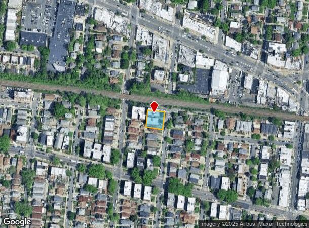
DEMOGRAPHICS near 4104 159Th St
1 mile
3 mile
5 mile
2024 Total Population
101,442
469,911
1,385,583
2029 Population
96,014
439,873
1,297,233
Pop Growth 2024-2029
(5.35%)
(6.39%)
(6.38%)
Average Age
45
43
42
2024 Total Households
35,233
161,910
478,272
HH Growth 2024-2029
(5.65%)
(6.65%)
(6.51%)
Median Household Inc
$53,581
$67,363
$71,281
Avg Household Size
2.80
2.80
2.80
2024 Avg HH Vehicles
1.00
1.00
1.00
Median Home Value
$750,118
$736,361
$685,445
Median Year Built
1954
1956
1954
Nearby Places
Map Layers
Map Styles
 Street
 Aerial
Transit
 Traffic
 Biking
Places
Listings with unknown addresses are not visible on the map
- Restaurants
- Banks
- Shops
- Fitness
- Groceries
PUBLIC TRANSPORTATION
TRANSIT/SUBWAY
Broadway Station (Port Washington Branch - Long Island Rail Road)
Drive
Walk
Distance
Broadway Station (Port Washington Branch - Long Island Rail Road)
2 min
7 min
0.3 mi
Murray Hill Station (Port Washington Branch - Long Island Rail Road)
Drive
Walk
Distance
Murray Hill Station (Port Washington Branch - Long Island Rail Road)
2 min
9 min
0.5 mi
Auburndale Station (Port Washington Branch - Long Island Rail Road)
Drive
Walk
Distance
Auburndale Station (Port Washington Branch - Long Island Rail Road)
4 min
20 min
1.0 mi
COMMUTER RAIL
Broadway Station (Port Washington Branch - Long Island Rail Road)
Drive
Walk
Distance
Broadway Station (Port Washington Branch - Long Island Rail Road)
2 min
7 min
0.4 mi
Murray Hill Station (Port Washington Branch - Long Island Rail Road)
Drive
Walk
Distance
Murray Hill Station (Port Washington Branch - Long Island Rail Road)
2 min
9 min
0.5 mi
AIRPORT
LaGuardia
Drive
Walk
Distance
LaGuardia
12 min
4.8 mi
John F Kennedy International
Drive
Walk
Distance
John F Kennedy International
18 min
11.2 mi
Newark Liberty International
Drive
Walk
Distance
Newark Liberty International
41 min
25.4 mi
Freight Ports
NY - Red Hook Container Terminal
Drive
Walk
Distance
NY - Red Hook Container Terminal
26 min
14.2 mi
SALE & LEASE HISTORY
LISTING DATE
SALE/LEASE

Mar 08, 2018
For Sale
Nearby Properties
Address
Land Use
TOTAL SIZE
Lot Size
Zoning
Address
Land Use
TOTAL SIZE
Lot Size
Zoning
4,528,000 SF
94.27 AC
R4
Address
Land Use
TOTAL SIZE
Lot Size
Zoning
2,078,606 SF
58.93 AC
R4
Address
Land Use
TOTAL SIZE
Lot Size
Zoning
1,258,350 SF
410.24 AC
PARK
Address
Land Use
TOTAL SIZE
Lot Size
Zoning
878,386 SF
20.55 AC
R4
Address
Land Use
TOTAL SIZE
Lot Size
Zoning
15,000 SF
255.27 AC
PARK
Address
Land Use
TOTAL SIZE
Lot Size
Zoning
421,996 SF
136.05 AC
R3-1
Address
Land Use
TOTAL SIZE
Lot Size
Zoning
554,300 SF
20.72 AC
R3-2
Address
Land Use
TOTAL SIZE
Lot Size
Zoning
554,300 SF
20.72 AC
R3-2
Address
Land Use
TOTAL SIZE
Lot Size
Zoning
4,050 SF
113.40 AC
PARK
Address
Land Use
TOTAL SIZE
Lot Size
Zoning
947 SF
101.82 AC
PARK
Address
Land Use
TOTAL SIZE
Lot Size
Zoning
4,800 SF
80.10 AC
PARK
Address
Land Use
TOTAL SIZE
Lot Size
Zoning
332,266 SF
12.57 AC
M2-1
Address
Land Use
TOTAL SIZE
Lot Size
Zoning
749,142 SF
16.48 AC
R6
Address
Land Use
TOTAL SIZE
Lot Size
Zoning
749,142 SF
16.48 AC
R6
Address
Land Use
TOTAL SIZE
Lot Size
Zoning
749,142 SF
16.48 AC
R6
Address
Land Use
TOTAL SIZE
Lot Size
Zoning
749,142 SF
16.48 AC
R6
Address
Land Use
TOTAL SIZE
Lot Size
Zoning
749,142 SF
16.48 AC
R6
Address
Land Use
TOTAL SIZE
Lot Size
Zoning
749,142 SF
16.48 AC
R6
Address
Land Use
TOTAL SIZE
Lot Size
Zoning
749,142 SF
16.48 AC
R6
Address
Land Use
TOTAL SIZE
Lot Size
Zoning
1,186,778 SF
31.45 AC
R4
Address
Land Use
TOTAL SIZE
Lot Size
Zoning
577,654 SF
5.38 AC
R6
Address
Land Use
TOTAL SIZE
Lot Size
Zoning
521,944 SF
16.68 AC
R4
Address
Land Use
TOTAL SIZE
Lot Size
Zoning
511,684 SF
13.09 AC
R4
Address
Land Use
TOTAL SIZE
Lot Size
Zoning
1,389,532 SF
31.54 AC
R6
Address
Land Use
TOTAL SIZE
Lot Size
Zoning
486,792 SF
12.10 AC
R5
Address
Land Use
TOTAL SIZE
Lot Size
Zoning
486,792 SF
12.10 AC
R5
Address
Land Use
TOTAL SIZE
Lot Size
Zoning
486,792 SF
12.10 AC
R5
Address
Land Use
TOTAL SIZE
Lot Size
Zoning
486,792 SF
12.10 AC
R5
Address
Land Use
TOTAL SIZE
Lot Size
Zoning
486,792 SF
12.10 AC
R5
Address
Land Use
TOTAL SIZE
Lot Size
Zoning
486,792 SF
12.10 AC
R5
The World's #1 Commercial Real Estate Marketplace
Connect with us
© 2026 CoStar Group
The information above has been obtained from sources believed reliable. While we do not doubt its accuracy we have not verified it and make no guarantee, warranty or representation about it. It is your responsibility to independently confirm its accuracy and completeness. Any projections, opinions, assumptions, or estimates used are for example only and do not represent the current or future performance of the property. The value of this transaction to you depends on tax and other factors which should be evaluated by your tax, financial, and legal advisors. You and your advisors should conduct a careful, independent investigation of the property to determine to your satisfaction the suitability of the property for your needs.