Property Record
4105 Highway 98 W, Summit, MS 39666
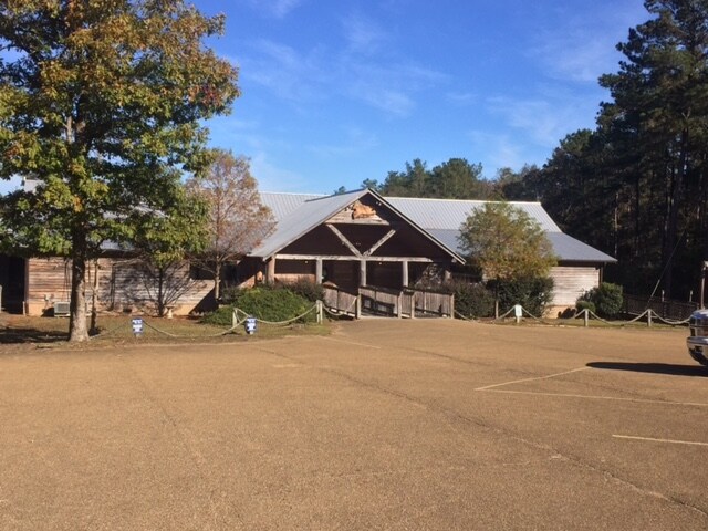

Property Detail
4105 Highway 98 W
712706-T
PT IN NW1/4 SE1/4 LY N OF HWY ZN:X-28113C0025C
Restaurantbuilding
Pike
B and X Area of moderate flood hazard, usually the area between the limits of the 100-year and 500-year floods.
Mississippi
2025
1.57 AC
2025
Hattiesburg/South Area
950102
Other Market Areas
7,535 SF
McComb, MS
NEARBY LISTINGS FOR SALE OR LEASE
-
-
View all Summit listings for sale on LoopNet.com
DEMOGRAPHICS near 4105 Highway 98 W
1 mile
3 mile
5 mile
2025 Total Population
311
4,404
16,358
2030 Population
305
4,290
15,933
Pop Growth 2025-2030
(1.93%)
(2.59%)
(2.60%)
Average Age
40
40
40
2025 Total Households
120
1,686
6,573
HH Growth 2025-2030
(2.50%)
(2.55%)
(2.62%)
Median Household Inc
$60,682
$53,182
$43,601
Avg Household Size
2.60
2.40
2.40
2025 Avg HH Vehicles
2.00
2.00
2.00
Median Home Value
$214,286
$176,867
$139,507
Median Year Built
1999
1987
1980
Nearby Places
Map Layers
Map Styles
 Street
 Aerial
Layers
 Traffic
 Biking
Places
Listings with unknown addresses are not visible on the map
- Restaurants
- Banks
- Shops
- Fitness
- Groceries
PUBLIC TRANSPORTATION
COMMUTER RAIL
Mccomb (City of New Orleans - Amtrak)
Drive
Walk
Distance
Mccomb (City of New Orleans - Amtrak)
9 min
6.2 mi
Freight Ports
Port of Greater Baton Rouge
Drive
Walk
Distance
Port of Greater Baton Rouge
118 min
103.7 mi
SALE & LEASE HISTORY
LISTING DATE
SALE/LEASE

Dec 27, 2016
For Sale
Dec 02, 2016
For Sale
Nearby Properties
Address
Land Use
TOTAL SIZE
Lot Size
Zoning
Address
Land Use
TOTAL SIZE
Lot Size
Zoning
220,645 SF
20.43 AC
CPL
Address
Land Use
TOTAL SIZE
Lot Size
Zoning
49,490 SF
2.36 AC
C2
Address
Land Use
TOTAL SIZE
Lot Size
Zoning
73,961 SF
1.94 AC
CPL
Address
Land Use
TOTAL SIZE
Lot Size
Zoning
187,912 SF
1 AC
CPL
Address
Land Use
TOTAL SIZE
Lot Size
Zoning
32,565 SF
1.49 AC
Address
Land Use
TOTAL SIZE
Lot Size
Zoning
35,177 SF
1.36 AC
C2
Address
Land Use
TOTAL SIZE
Lot Size
Zoning
12,092 SF
12.24 AC
Address
Land Use
TOTAL SIZE
Lot Size
Zoning
97,627 SF
1 AC
CPL
Address
Land Use
TOTAL SIZE
Lot Size
Zoning
30,090 SF
7.39 AC
CPL
Address
Land Use
TOTAL SIZE
Lot Size
Zoning
5,146 SF
1.38 AC
Address
Land Use
TOTAL SIZE
Lot Size
Zoning
66,584 SF
13.50 AC
I1
Address
Land Use
TOTAL SIZE
Lot Size
Zoning
21,210 SF
2.88 AC
I1
Address
Land Use
TOTAL SIZE
Lot Size
Zoning
11,334 SF
2.50 AC
Address
Land Use
TOTAL SIZE
Lot Size
Zoning
4,067 SF
1.28 AC
CPL
Address
Land Use
TOTAL SIZE
Lot Size
Zoning
4,693 SF
0.84 AC
CPL
Address
Land Use
TOTAL SIZE
Lot Size
Zoning
5,138 SF
1.04 AC
CPL
Address
Land Use
TOTAL SIZE
Lot Size
Zoning
5,653 SF
1.83 AC
CPL
Address
Land Use
TOTAL SIZE
Lot Size
Zoning
2,400 SF
3.84 AC
C2
Address
Land Use
TOTAL SIZE
Lot Size
Zoning
8,389 SF
0.72 AC
Address
Land Use
TOTAL SIZE
Lot Size
Zoning
8,981 SF
26.92 AC
C2
Address
Land Use
TOTAL SIZE
Lot Size
Zoning
12,623 SF
1.62 AC
Address
Land Use
TOTAL SIZE
Lot Size
Zoning
4,731 SF
1.88 AC
R1
Address
Land Use
TOTAL SIZE
Lot Size
Zoning
2,556 SF
0.76 AC
CPL
Address
Land Use
TOTAL SIZE
Lot Size
Zoning
9,556 SF
1.12 AC
C2
Address
Land Use
TOTAL SIZE
Lot Size
Zoning
3,220 SF
1.32 AC
C2
Address
Land Use
TOTAL SIZE
Lot Size
Zoning
3,902 SF
1.94 AC
C1
Address
Land Use
TOTAL SIZE
Lot Size
Zoning
6,948 SF
4.93 AC
Address
Land Use
TOTAL SIZE
Lot Size
Zoning
23,280 SF
9.72 AC
C2
Address
Land Use
TOTAL SIZE
Lot Size
Zoning
3,902 SF
0.51 AC
CPL
Address
Land Use
TOTAL SIZE
Lot Size
Zoning
7,206 SF
1 AC
CPL
The World's #1 Commercial Real Estate Marketplace
Connect with us
© 2026 CoStar Group
The information above has been obtained from sources believed reliable. While we do not doubt its accuracy we have not verified it and make no guarantee, warranty or representation about it. It is your responsibility to independently confirm its accuracy and completeness. Any projections, opinions, assumptions, or estimates used are for example only and do not represent the current or future performance of the property. The value of this transaction to you depends on tax and other factors which should be evaluated by your tax, financial, and legal advisors. You and your advisors should conduct a careful, independent investigation of the property to determine to your satisfaction the suitability of the property for your needs.