Property Record
4107 Highway 52 N, Rochester, MN 55901
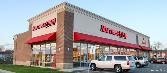

This Property Is For Sale
NEARBY LISTINGS FOR SALE OR LEASE
Property Detail
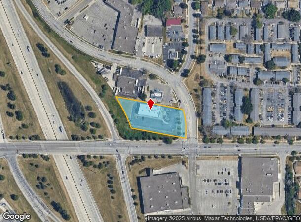
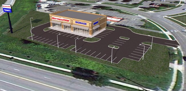
4107 Highway 52 N
Rochester, MN
Pennington Business Pk 4Th Sub
74.15.33.019284
SECT-15 TWP-107 RANGE-014 PENNINGTON BUSINESS PK 4TH SUB LOT-001 BLOCK-001 1.29 AC TH PT OF LOT 1 BLK 1 DES AS FOLL BEG AT SE
Stripcommercialcenter
Olmsted
X
Minnesota
27109C0153F
1
2025
1.29 AC
2024
Rochester
001701
Other Market Areas
7,522 SF
DEMOGRAPHICS near 4107 Highway 52 N
1 Mile
3 Mile
5 Mile
2024 Total Population
11,212
62,089
107,906
2029 Population
11,384
63,383
110,794
Pop Growth 2024-2029
+ 1.53%
+ 2.08%
+ 2.68%
Average Age
37
38
39
2024 Total Households
4,524
25,169
44,748
HH Growth 2024-2029
+ 1.55%
+ 1.99%
+ 2.70%
Median Household Inc
$65,230
$83,906
$79,863
Avg Household Size
2.30
2.40
2.30
2024 Avg HH Vehicles
2.00
2.00
2.00
Median Home Value
$239,605
$268,176
$280,049
Median Year Built
1985
1988
1986
Nearby Places
- Restaurants
- Banks
- Shops
- Fitness
- Groceries
PUBLIC TRANSPORTATION
AIRPORT
Rochester International
DRIVE
WALK
Distance
Rochester International
17 min
12.3 mi
Freight Ports
Port Milwaukee
DRIVE
WALK
Distance
Port Milwaukee
310 min
281.7 mi
Nearby Properties
Address
Land Use
TOTAL SIZE
Lot Size
Zoning
Address
Land Use
TOTAL SIZE
Lot Size
Zoning
1,232,028 SF
2.03 AC
Address
Land Use
TOTAL SIZE
Lot Size
Zoning
271,310 SF
27.90 AC
Address
Land Use
TOTAL SIZE
Lot Size
Zoning
4,612 SF
21.16 AC
Address
Land Use
TOTAL SIZE
Lot Size
Zoning
6,082 SF
31.75 AC
Address
Land Use
TOTAL SIZE
Lot Size
Zoning
960 SF
38.12 AC
Address
Land Use
TOTAL SIZE
Lot Size
Zoning
13,946 SF
34.10 AC
Address
Land Use
TOTAL SIZE
Lot Size
Zoning
236,769 SF
33.30 AC
Address
Land Use
TOTAL SIZE
Lot Size
Zoning
12,016 SF
20.31 AC
Address
Land Use
TOTAL SIZE
Lot Size
Zoning
2,420 SF
10.37 AC
Address
Land Use
TOTAL SIZE
Lot Size
Zoning
195,039 SF
8.25 AC
Address
Land Use
TOTAL SIZE
Lot Size
Zoning
53.73 AC
Address
Land Use
TOTAL SIZE
Lot Size
Zoning
167.09 AC
Address
Land Use
TOTAL SIZE
Lot Size
Zoning
4.63 AC
Address
Land Use
TOTAL SIZE
Lot Size
Zoning
250,864 SF
4.43 AC
Address
Land Use
TOTAL SIZE
Lot Size
Zoning
136,031 SF
35.28 AC
Address
Land Use
TOTAL SIZE
Lot Size
Zoning
170,843 SF
13.66 AC
Address
Land Use
TOTAL SIZE
Lot Size
Zoning
2,300 SF
6.38 AC
Address
Land Use
TOTAL SIZE
Lot Size
Zoning
3,024 SF
4.93 AC
Address
Land Use
TOTAL SIZE
Lot Size
Zoning
3,915 SF
12.56 AC
Address
Land Use
TOTAL SIZE
Lot Size
Zoning
10,920 SF
38.88 AC
Address
Land Use
TOTAL SIZE
Lot Size
Zoning
Address
Land Use
TOTAL SIZE
Lot Size
Zoning
142,236 SF
13.78 AC
Address
Land Use
TOTAL SIZE
Lot Size
Zoning
117,897 SF
34.12 AC
Address
Land Use
TOTAL SIZE
Lot Size
Zoning
105,499 SF
0.85 AC
Address
Land Use
TOTAL SIZE
Lot Size
Zoning
72,675 SF
11.25 AC
Address
Land Use
TOTAL SIZE
Lot Size
Zoning
2,880 SF
9.49 AC
Address
Land Use
TOTAL SIZE
Lot Size
Zoning
77,176 SF
11.05 AC
Address
Land Use
TOTAL SIZE
Lot Size
Zoning
66,713 SF
8.79 AC
Address
Land Use
TOTAL SIZE
Lot Size
Zoning
528 SF
15.22 AC
Address
Land Use
TOTAL SIZE
Lot Size
Zoning
4,994 SF
7.92 AC
The World's #1 Commercial Real Estate Marketplace
Connect with us
© 2025 CoStar Group
The information above has been obtained from sources believed reliable. While we do not doubt its accuracy we have not verified it and make no guarantee, warranty or representation about it. It is your responsibility to independently confirm its accuracy and completeness. Any projections, opinions, assumptions, or estimates used are for example only and do not represent the current or future performance of the property. The value of this transaction to you depends on tax and other factors which should be evaluated by your tax, financial, and legal advisors. You and your advisors should conduct a careful, independent investigation of the property to determine to your satisfaction the suitability of the property for your needs.