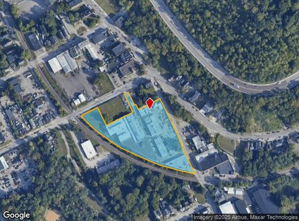
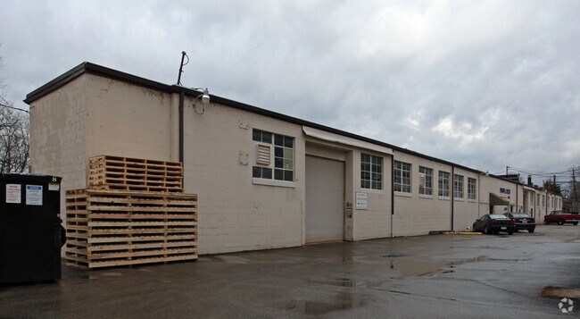
Property Record
4109 Airport Rd, Cincinnati, OH 45226

NEARBY LISTINGS FOR SALE OR LEASE
Property Detail
4109 Airport Rd
Cincinnati, OH-KY-IN
120.4X120IR LT13P5-6-12 MCCULLOUGHSUBPERCOMMRS PTLT230OLDTOWNOFCOL&LNDADJ PRS66-75T78-82-120CO
024-0001-0066
Hamilton
Storebuilding
Ohio
AE
13
39061C0356G
3.38 AC
2024
Central/Midtown
2024
Cincinnati/Dayton
026600
DEMOGRAPHICS near 4109 Airport Rd
1 Mile
3 Mile
5 Mile
2024 Total Population
3,212
71,635
264,584
2029 Population
3,193
71,601
265,878
Pop Growth 2024-2029
(0.59%)
(0.05%)
+ 0.49%
Average Age
39
40
38
2024 Total Households
1,539
33,018
119,358
HH Growth 2024-2029
(0.78%)
(0.24%)
+ 0.52%
Median Household Inc
$104,052
$89,600
$66,110
Avg Household Size
2.00
2.10
2.00
2024 Avg HH Vehicles
2.00
2.00
2.00
Median Home Value
$405,660
$302,454
$257,399
Median Year Built
1964
1949
1951
Nearby Places
Map Layers
Map Styles
 Street
 Aerial
- Restaurants
- Banks
- Shops
- Fitness
- Groceries
PUBLIC TRANSPORTATION
COMMUTER RAIL
Cincinnati Union Terminal (Cardinal - Amtrak)
DRIVE
WALK
Distance
Cincinnati Union Terminal (Cardinal - Amtrak)
15 min
7.5 mi
AIRPORT
Cincinnati/Northern Kentucky International
DRIVE
WALK
Distance
Cincinnati/Northern Kentucky International
35 min
19.9 mi
Freight Ports
Port of Toledo
DRIVE
WALK
Distance
Port of Toledo
247 min
205.9 mi
Nearby Properties
Address
Land Use
TOTAL SIZE
Lot Size
Zoning
Address
Land Use
TOTAL SIZE
Lot Size
Zoning
13.80 AC
Address
Land Use
TOTAL SIZE
Lot Size
Zoning
411,750 SF
21.25 AC
Address
Land Use
TOTAL SIZE
Lot Size
Zoning
27.30 AC
M2
Address
Land Use
TOTAL SIZE
Lot Size
Zoning
153,312 SF
4 AC
Address
Land Use
TOTAL SIZE
Lot Size
Zoning
11.68 AC
Address
Land Use
TOTAL SIZE
Lot Size
Zoning
165,016 SF
15.23 AC
Address
Land Use
TOTAL SIZE
Lot Size
Zoning
12,150 SF
10.02 AC
Address
Land Use
TOTAL SIZE
Lot Size
Zoning
26,453 SF
19.91 AC
M2
Address
Land Use
TOTAL SIZE
Lot Size
Zoning
60,772 SF
0.78 AC
Address
Land Use
TOTAL SIZE
Lot Size
Zoning
148,748 SF
24.90 AC
CGA
Address
Land Use
TOTAL SIZE
Lot Size
Zoning
119,574 SF
10.40 AC
Address
Land Use
TOTAL SIZE
Lot Size
Zoning
Address
Land Use
TOTAL SIZE
Lot Size
Zoning
70,541 SF
7.08 AC
Address
Land Use
TOTAL SIZE
Lot Size
Zoning
134,500 SF
9.68 AC
Address
Land Use
TOTAL SIZE
Lot Size
Zoning
109,000 SF
3.28 AC
Address
Land Use
TOTAL SIZE
Lot Size
Zoning
25,740 SF
0.07 AC
Address
Land Use
TOTAL SIZE
Lot Size
Zoning
12.46 AC
Address
Land Use
TOTAL SIZE
Lot Size
Zoning
15,892 SF
0.46 AC
Address
Land Use
TOTAL SIZE
Lot Size
Zoning
89,925 SF
1.72 AC
Address
Land Use
TOTAL SIZE
Lot Size
Zoning
83,122 SF
1.99 AC
Address
Land Use
TOTAL SIZE
Lot Size
Zoning
24,572 SF
4.70 AC
Address
Land Use
TOTAL SIZE
Lot Size
Zoning
22,188 SF
8.88 AC
Address
Land Use
TOTAL SIZE
Lot Size
Zoning
3,864 SF
0.15 AC
PD
Address
Land Use
TOTAL SIZE
Lot Size
Zoning
33,468 SF
1.04 AC
Address
Land Use
TOTAL SIZE
Lot Size
Zoning
2.59 AC
Address
Land Use
TOTAL SIZE
Lot Size
Zoning
2.17 AC
O
Address
Land Use
TOTAL SIZE
Lot Size
Zoning
9,515 SF
19.13 AC
Address
Land Use
TOTAL SIZE
Lot Size
Zoning
45,604 SF
0.64 AC
Address
Land Use
TOTAL SIZE
Lot Size
Zoning
2.20 AC
Address
Land Use
TOTAL SIZE
Lot Size
Zoning
84,028 SF
0.52 AC
The World's #1 Commercial Real Estate Marketplace
Connect with us
© 2025 CoStar Group
The information above has been obtained from sources believed reliable. While we do not doubt its accuracy we have not verified it and make no guarantee, warranty or representation about it. It is your responsibility to independently confirm its accuracy and completeness. Any projections, opinions, assumptions, or estimates used are for example only and do not represent the current or future performance of the property. The value of this transaction to you depends on tax and other factors which should be evaluated by your tax, financial, and legal advisors. You and your advisors should conduct a careful, independent investigation of the property to determine to your satisfaction the suitability of the property for your needs.