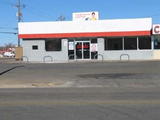
Property Record
4109 S Western St, Amarillo, TX 79109

Property Detail
4109 S Western St
R-061-5400-3560
PARAMOUNT TERRACE # 12, BLK 0060, IRREG 132.33FT OF BLK BEG IN SW COR
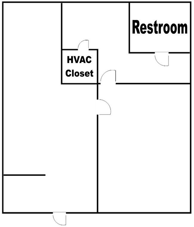
Storebuilding
Randall
GR
Texas
B and X Area of moderate flood hazard, usually the area between the limits of the 100-year and 500-year floods.
1,2
2024
0.35 AC
2025
Amarillo
021101
Other Market Areas
3,730 SF
Amarillo, TX
NEARBY LISTINGS FOR SALE OR LEASE
DEMOGRAPHICS near 4109 S Western St
1 mile
3 mile
5 mile
2024 Total Population
16,110
104,845
157,829
2029 Population
16,885
108,124
162,398
Pop Growth 2024-2029
+ 4.81%
+ 3.13%
+ 2.89%
Average Age
39
39
39
2024 Total Households
7,255
43,998
64,830
HH Growth 2024-2029
+ 4.96%
+ 3.05%
+ 2.83%
Median Household Inc
$52,134
$68,893
$67,352
Avg Household Size
2.10
2.30
2.30
2024 Avg HH Vehicles
2.00
2.00
2.00
Median Home Value
$206,482
$220,463
$219,293
Median Year Built
1971
1974
1975
Nearby Places
Map Layers
Map Styles
 Street
 Aerial
Transit
 Traffic
 Biking
Places
Listings with unknown addresses are not visible on the map
- Restaurants
- Banks
- Shops
- Fitness
- Groceries
PUBLIC TRANSPORTATION
AIRPORT
Rick Husband Amarillo International
Drive
Walk
Distance
Rick Husband Amarillo International
23 min
13.2 mi
SALE & LEASE HISTORY
LISTING DATE
SALE/LEASE

Jul 29, 2021
For Lease
Nearby Properties
Address
Land Use
TOTAL SIZE
Lot Size
Zoning
Address
Land Use
TOTAL SIZE
Lot Size
Zoning
480,593 SF
30.60 AC
O
Address
Land Use
TOTAL SIZE
Lot Size
Zoning
1,341,178 SF
16.26 AC
PD2
Address
Land Use
TOTAL SIZE
Lot Size
Zoning
431,320 SF
14.82 AC
1F2 S
Address
Land Use
TOTAL SIZE
Lot Size
Zoning
342,930 SF
34.57 AC
PD
Address
Land Use
TOTAL SIZE
Lot Size
Zoning
168,978 SF
4.23 AC
1F2 S
Address
Land Use
TOTAL SIZE
Lot Size
Zoning
207,120 SF
16.54 AC
GR
Address
Land Use
TOTAL SIZE
Lot Size
Zoning
345,555 SF
23.69 AC
PD
Address
Land Use
TOTAL SIZE
Lot Size
Zoning
373,014 SF
14.20 AC
Address
Land Use
TOTAL SIZE
Lot Size
Zoning
116,842 SF
4.17 AC
Address
Land Use
TOTAL SIZE
Lot Size
Zoning
129,829 SF
14.50 AC
PD2
Address
Land Use
TOTAL SIZE
Lot Size
Zoning
260,680 SF
10.16 AC
Address
Land Use
TOTAL SIZE
Lot Size
Zoning
145,652 SF
20.53 AC
Address
Land Use
TOTAL SIZE
Lot Size
Zoning
485,065 SF
38.89 AC
Address
Land Use
TOTAL SIZE
Lot Size
Zoning
485,065 SF
38.89 AC
Address
Land Use
TOTAL SIZE
Lot Size
Zoning
229,869 SF
10.85 AC
Address
Land Use
TOTAL SIZE
Lot Size
Zoning
168,130 SF
16.32 AC
Address
Land Use
TOTAL SIZE
Lot Size
Zoning
182,242 SF
20.70 AC
Address
Land Use
TOTAL SIZE
Lot Size
Zoning
210,217 SF
10.49 AC
M11
Address
Land Use
TOTAL SIZE
Lot Size
Zoning
74,960 SF
7 AC
R2
Address
Land Use
TOTAL SIZE
Lot Size
Zoning
204,468 SF
17.56 AC
Address
Land Use
TOTAL SIZE
Lot Size
Zoning
99,739 SF
3.88 AC
R2
Address
Land Use
TOTAL SIZE
Lot Size
Zoning
167,257 SF
12.66 AC
Address
Land Use
TOTAL SIZE
Lot Size
Zoning
161,221 SF
11.78 AC
MF1
Address
Land Use
TOTAL SIZE
Lot Size
Zoning
112,005 SF
7.70 AC
GR
Address
Land Use
TOTAL SIZE
Lot Size
Zoning
227,707 SF
10.78 AC
GR
Address
Land Use
TOTAL SIZE
Lot Size
Zoning
200,117 SF
7.96 AC
GR
Address
Land Use
TOTAL SIZE
Lot Size
Zoning
183,758 SF
16.74 AC
R2
Address
Land Use
TOTAL SIZE
Lot Size
Zoning
132,914 SF
10.20 AC
PD
Address
Land Use
TOTAL SIZE
Lot Size
Zoning
185,895 SF
9.59 AC
The World's #1 Commercial Real Estate Marketplace
Connect with us
© 2026 CoStar Group
The information above has been obtained from sources believed reliable. While we do not doubt its accuracy we have not verified it and make no guarantee, warranty or representation about it. It is your responsibility to independently confirm its accuracy and completeness. Any projections, opinions, assumptions, or estimates used are for example only and do not represent the current or future performance of the property. The value of this transaction to you depends on tax and other factors which should be evaluated by your tax, financial, and legal advisors. You and your advisors should conduct a careful, independent investigation of the property to determine to your satisfaction the suitability of the property for your needs.