Property Record
411 Dee Jay Hudson Dr, Sherwood, AR 72120
NEARBY LISTINGS FOR SALE OR LEASE
-
-
View all Sherwood listings for sale on LoopNet.com
Property Detail
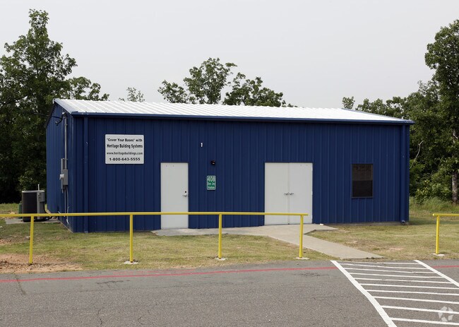
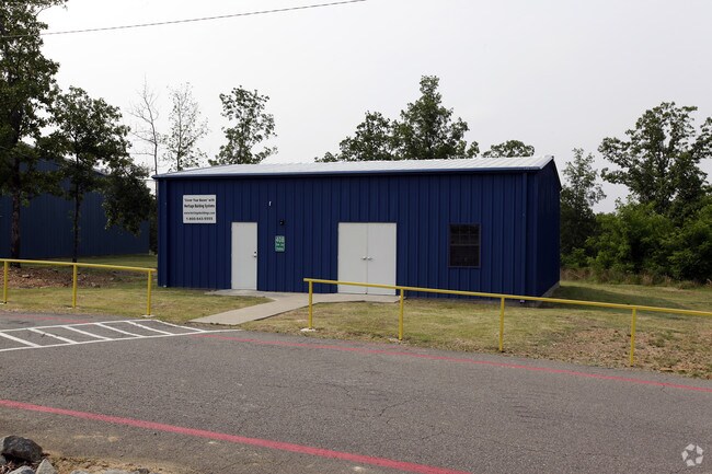
411 Dee Jay Hudson Dr
Little Rock-North Little Rock-Conway, AR
Sherwood Forest Commercial
32S-001-00-002-00
PT SEC 36 BEG NW COR SE NW TH N89*1037E1331.46 TO NE COR SE NW TH N89*139E1330.04 TO NE COR SW NE TH S51*925E211.89 TO NLY R/W BEAR PAW DR TH S38*5035W 125.56 AL CRV TO RGT RADIUS 204.86 CHORD BEARING S68*747W200.43 N82*35W128.54 S0*5EA
Commercialnec
Pulaski
X
Arkansas
05119C0355G
1
2025
145.44 AC
2025
Outlying Pulaski County
003713
Little Rock/N Little Rock
19,163 SF
DEMOGRAPHICS near 411 Dee Jay Hudson Dr
1 Mile
3 Mile
5 Mile
2024 Total Population
3,242
36,425
78,390
2029 Population
3,234
36,053
77,981
Pop Growth 2024-2029
(0.25%)
(1.02%)
(0.52%)
Average Age
41
41
40
2024 Total Households
1,351
15,215
33,463
HH Growth 2024-2029
(0.37%)
(1.09%)
(0.51%)
Median Household Inc
$71,549
$71,393
$59,648
Avg Household Size
2.40
2.40
2.30
2024 Avg HH Vehicles
2.00
2.00
2.00
Median Home Value
$197,623
$189,058
$172,966
Median Year Built
1990
1982
1977
Nearby Places
Map Layers
Map Styles
 Street
 Aerial
- Restaurants
- Banks
- Shops
- Fitness
- Groceries
PUBLIC TRANSPORTATION
COMMUTER RAIL
Little Rock Union Station (Texas Eagle - Amtrak)
DRIVE
WALK
Distance
Little Rock Union Station (Texas Eagle - Amtrak)
17 min
9.1 mi
AIRPORT
Bill and Hillary Clinton Ntl/Adams Field
DRIVE
WALK
Distance
Bill and Hillary Clinton Ntl/Adams Field
23 min
13.3 mi
Freight Ports
Port of Shreveport
DRIVE
WALK
Distance
Port of Shreveport
265 min
242.2 mi
Nearby Properties
Address
Land Use
TOTAL SIZE
Lot Size
Zoning
Address
Land Use
TOTAL SIZE
Lot Size
Zoning
316,927 SF
50.65 AC
Address
Land Use
TOTAL SIZE
Lot Size
Zoning
195,404 SF
25.19 AC
Address
Land Use
TOTAL SIZE
Lot Size
Zoning
17,352 SF
42.55 AC
Address
Land Use
TOTAL SIZE
Lot Size
Zoning
219,330 SF
24.14 AC
Address
Land Use
TOTAL SIZE
Lot Size
Zoning
83,431 SF
10.99 AC
Address
Land Use
TOTAL SIZE
Lot Size
Zoning
49,995 SF
12.92 AC
Address
Land Use
TOTAL SIZE
Lot Size
Zoning
72,157 SF
9.45 AC
Address
Land Use
TOTAL SIZE
Lot Size
Zoning
56,643 SF
9.46 AC
Address
Land Use
TOTAL SIZE
Lot Size
Zoning
8,520 SF
11.30 AC
Address
Land Use
TOTAL SIZE
Lot Size
Zoning
49,393 SF
5.31 AC
Address
Land Use
TOTAL SIZE
Lot Size
Zoning
45,500 SF
12.07 AC
Address
Land Use
TOTAL SIZE
Lot Size
Zoning
145,604 SF
12.62 AC
Address
Land Use
TOTAL SIZE
Lot Size
Zoning
32,788 SF
3.99 AC
Address
Land Use
TOTAL SIZE
Lot Size
Zoning
44,092 SF
7.97 AC
Address
Land Use
TOTAL SIZE
Lot Size
Zoning
3,306 SF
8.33 AC
Address
Land Use
TOTAL SIZE
Lot Size
Zoning
40,065 SF
8.26 AC
Address
Land Use
TOTAL SIZE
Lot Size
Zoning
35,645 SF
7.97 AC
Address
Land Use
TOTAL SIZE
Lot Size
Zoning
105,833 SF
21.94 AC
Address
Land Use
TOTAL SIZE
Lot Size
Zoning
7,975 SF
3.96 AC
Address
Land Use
TOTAL SIZE
Lot Size
Zoning
166,470 SF
392.03 AC
Address
Land Use
TOTAL SIZE
Lot Size
Zoning
29,600 SF
4.43 AC
Address
Land Use
TOTAL SIZE
Lot Size
Zoning
12,990 SF
5.72 AC
Address
Land Use
TOTAL SIZE
Lot Size
Zoning
32,256 SF
6.22 AC
Address
Land Use
TOTAL SIZE
Lot Size
Zoning
97,980 SF
5.89 AC
Address
Land Use
TOTAL SIZE
Lot Size
Zoning
1,353 SF
0.68 AC
M-H
Address
Land Use
TOTAL SIZE
Lot Size
Zoning
24,678 SF
108.23 AC
Address
Land Use
TOTAL SIZE
Lot Size
Zoning
14,416 SF
3.54 AC
Address
Land Use
TOTAL SIZE
Lot Size
Zoning
90,914 SF
2.88 AC
Address
Land Use
TOTAL SIZE
Lot Size
Zoning
41,848 SF
4.15 AC
Address
Land Use
TOTAL SIZE
Lot Size
Zoning
46,051 SF
12.58 AC
The World's #1 Commercial Real Estate Marketplace
Connect with us
© 2025 CoStar Group
The information above has been obtained from sources believed reliable. While we do not doubt its accuracy we have not verified it and make no guarantee, warranty or representation about it. It is your responsibility to independently confirm its accuracy and completeness. Any projections, opinions, assumptions, or estimates used are for example only and do not represent the current or future performance of the property. The value of this transaction to you depends on tax and other factors which should be evaluated by your tax, financial, and legal advisors. You and your advisors should conduct a careful, independent investigation of the property to determine to your satisfaction the suitability of the property for your needs.