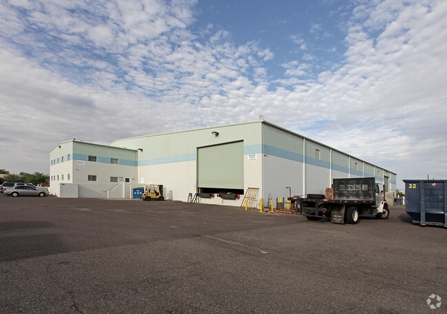
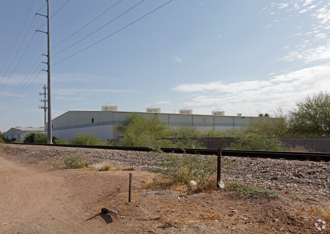
Property Record
411 E Ray Rd, Chandler, AZ 85225


Property Detail
411 E Ray Rd
302-67-005D
W 460F OF W2 NE4 NW4 EX RR R/W & EX N 54F RD
Warehouse
Maricopa
I-2
Arizona
AH Areas with a 1% annual chance of shallow flooding, usually in the form of a pond, withan average depth ranging from 1 to 3 feet. These areas have a 26% chance of flooding over the life of a 30-year mortgage.
11.45 AC
2025
Chandler N/Gilbert
2025
Phoenix
522903
Phoenix-Mesa-Chandler, AZ
106,150 SF
NEARBY LISTINGS FOR SALE OR LEASE
DEMOGRAPHICS near 411 E Ray Rd
1 mile
3 mile
5 mile
2025 Total Population
22,429
146,700
324,322
2030 Population
23,088
151,247
334,378
Pop Growth 2025-2030
+ 2.94%
+ 3.10%
+ 3.10%
Average Age
35
38
38
2025 Total Households
7,642
55,030
120,969
HH Growth 2025-2030
+ 3.06%
+ 3.13%
+ 3.14%
Median Household Inc
$74,391
$94,857
$103,520
Avg Household Size
2.80
2.60
2.60
2025 Avg HH Vehicles
2.00
2.00
2.00
Median Home Value
$387,010
$461,698
$493,897
Median Year Built
1989
1992
1993
Nearby Places
Map Layers
Map Styles
 Street
 Aerial
Transit
 Traffic
 Biking
Places
Listings with unknown addresses are not visible on the map
- Restaurants
- Banks
- Shops
- Fitness
- Groceries
PUBLIC TRANSPORTATION
AIRPORT
Phoenix-Mesa Gateway
Drive
Walk
Distance
Phoenix-Mesa Gateway
20 min
10.6 mi
Phoenix Sky Harbor International
Drive
Walk
Distance
Phoenix Sky Harbor International
28 min
18.2 mi
Freight Ports
Port of San Diego
Drive
Walk
Distance
Port of San Diego
403 min
366.7 mi
Nearby Properties
Address
Land Use
TOTAL SIZE
Lot Size
Zoning
Address
Land Use
TOTAL SIZE
Lot Size
Zoning
733,019 SF
13.13 AC
PAD
Address
Land Use
TOTAL SIZE
Lot Size
Zoning
1.13 AC
Address
Land Use
TOTAL SIZE
Lot Size
Zoning
301,190 SF
77.17 AC
PF
Address
Land Use
TOTAL SIZE
Lot Size
Zoning
984,487 SF
37.54 AC
I-1
Address
Land Use
TOTAL SIZE
Lot Size
Zoning
263,599 SF
18.33 AC
PAD
Address
Land Use
TOTAL SIZE
Lot Size
Zoning
15,066 SF
2.54 AC
PAD
Address
Land Use
TOTAL SIZE
Lot Size
Zoning
416,954 SF
9.59 AC
PF
Address
Land Use
TOTAL SIZE
Lot Size
Zoning
416,098 SF
22.48 AC
Address
Land Use
TOTAL SIZE
Lot Size
Zoning
348,249 SF
6.42 AC
M-H
Address
Land Use
TOTAL SIZE
Lot Size
Zoning
374,847 SF
20.84 AC
PAD
Address
Land Use
TOTAL SIZE
Lot Size
Zoning
269,504 SF
8.87 AC
I-1
Address
Land Use
TOTAL SIZE
Lot Size
Zoning
465,645 SF
30.78 AC
PAD
Address
Land Use
TOTAL SIZE
Lot Size
Zoning
403,326 SF
8.71 AC
PAD
Address
Land Use
TOTAL SIZE
Lot Size
Zoning
444,802 SF
4.17 AC
I-1
Address
Land Use
TOTAL SIZE
Lot Size
Zoning
22,149 SF
6.33 AC
PAD
Address
Land Use
TOTAL SIZE
Lot Size
Zoning
324,283 SF
18.75 AC
PAD
Address
Land Use
TOTAL SIZE
Lot Size
Zoning
348,379 SF
6.49 AC
PAD
Address
Land Use
TOTAL SIZE
Lot Size
Zoning
309,031 SF
18.55 AC
Address
Land Use
TOTAL SIZE
Lot Size
Zoning
185,744 SF
36.64 AC
PF
Address
Land Use
TOTAL SIZE
Lot Size
Zoning
372,953 SF
14.36 AC
C-C
Address
Land Use
TOTAL SIZE
Lot Size
Zoning
357,691 SF
19.87 AC
PAD
Address
Land Use
TOTAL SIZE
Lot Size
Zoning
272,380 SF
15.30 AC
PAD
Address
Land Use
TOTAL SIZE
Lot Size
Zoning
383,461 SF
25.76 AC
PAD
Address
Land Use
TOTAL SIZE
Lot Size
Zoning
358,620 SF
18.72 AC
PAD
Address
Land Use
TOTAL SIZE
Lot Size
Zoning
319,061 SF
18.51 AC
PAD
Address
Land Use
TOTAL SIZE
Lot Size
Zoning
237,329 SF
9.76 AC
C-N
Address
Land Use
TOTAL SIZE
Lot Size
Zoning
253,276 SF
18.33 AC
PAD
Address
Land Use
TOTAL SIZE
Lot Size
Zoning
118,172 SF
25.30 AC
SCHOOL
Address
Land Use
TOTAL SIZE
Lot Size
Zoning
273,805 SF
7.73 AC
MF-2
Address
Land Use
TOTAL SIZE
Lot Size
Zoning
115,920 SF
18.19 AC
The World's #1 Commercial Real Estate Marketplace
Connect with us
© 2026 CoStar Group
The information above has been obtained from sources believed reliable. While we do not doubt its accuracy we have not verified it and make no guarantee, warranty or representation about it. It is your responsibility to independently confirm its accuracy and completeness. Any projections, opinions, assumptions, or estimates used are for example only and do not represent the current or future performance of the property. The value of this transaction to you depends on tax and other factors which should be evaluated by your tax, financial, and legal advisors. You and your advisors should conduct a careful, independent investigation of the property to determine to your satisfaction the suitability of the property for your needs.