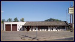
Property Record
411 Fraine Barracks Rd, Bismarck, ND 58504

NEARBY LISTINGS FOR SALE OR LEASE
Property Detail
411 Fraine Barracks Rd
Bismarck, ND
River Heights
0185-002-005
RIVER HEIGHTS THAT PART OF BLK 2 RIVER HEIGHTS ADDN DESCR MORE SPECIFICALLY AS: BEG @ SE CORNER OF BLK 2 THENCE NLYALONG THE
Storebuilding
Burleigh
X
North Dakota
38015C0790E
5
2024
0.51 AC
2024
Riverfront
010600
Other Market Areas
7,038 SF
DEMOGRAPHICS near 411 Fraine Barracks Rd
1 Mile
3 Mile
5 Mile
2024 Total Population
5,932
58,654
99,195
2029 Population
6,092
60,466
102,409
Pop Growth 2024-2029
+ 2.70%
+ 3.09%
+ 3.24%
Average Age
39
41
40
2024 Total Households
2,493
26,159
42,620
HH Growth 2024-2029
+ 2.77%
+ 3.16%
+ 3.27%
Median Household Inc
$72,929
$60,322
$66,558
Avg Household Size
2.20
2.10
2.20
2024 Avg HH Vehicles
2.00
2.00
2.00
Median Home Value
$256,699
$251,819
$257,461
Median Year Built
1976
1978
1983
Nearby Places
Map Layers
Map Styles
 Street
 Aerial
- Restaurants
- Banks
- Shops
- Fitness
- Groceries
PUBLIC TRANSPORTATION
AIRPORT
Bismarck Municipal
DRIVE
WALK
Distance
Bismarck Municipal
18 min
5.9 mi
Nearby Properties
Address
Land Use
TOTAL SIZE
Lot Size
Zoning
Address
Land Use
TOTAL SIZE
Lot Size
Zoning
45.23 AC
CG
Address
Land Use
TOTAL SIZE
Lot Size
Zoning
13.47 AC
PUD
Address
Land Use
TOTAL SIZE
Lot Size
Zoning
93,860 SF
1.44 AC
HM
Address
Land Use
TOTAL SIZE
Lot Size
Zoning
Address
Land Use
TOTAL SIZE
Lot Size
Zoning
70,182 SF
3.83 AC
PUD
Address
Land Use
TOTAL SIZE
Lot Size
Zoning
44,652 SF
13.84 AC
RM30
Address
Land Use
TOTAL SIZE
Lot Size
Zoning
6.29 AC
RM30
Address
Land Use
TOTAL SIZE
Lot Size
Zoning
81,092 SF
4.17 AC
HM
Address
Land Use
TOTAL SIZE
Lot Size
Zoning
38,467 SF
13.89 AC
CG
Address
Land Use
TOTAL SIZE
Lot Size
Zoning
16.12 AC
CG
Address
Land Use
TOTAL SIZE
Lot Size
Zoning
13.98 AC
CG
Address
Land Use
TOTAL SIZE
Lot Size
Zoning
51,723 SF
1.69 AC
HM
Address
Land Use
TOTAL SIZE
Lot Size
Zoning
10.84 AC
CG
Address
Land Use
TOTAL SIZE
Lot Size
Zoning
57,580 SF
8.85 AC
CG
Address
Land Use
TOTAL SIZE
Lot Size
Zoning
14.70 AC
MA
Address
Land Use
TOTAL SIZE
Lot Size
Zoning
8.64 AC
ETZ
Address
Land Use
TOTAL SIZE
Lot Size
Zoning
62,652 SF
2.34 AC
HM
Address
Land Use
TOTAL SIZE
Lot Size
Zoning
99,684 SF
2.33 AC
MA
Address
Land Use
TOTAL SIZE
Lot Size
Zoning
74,250 SF
5.63 AC
PUD
Address
Land Use
TOTAL SIZE
Lot Size
Zoning
15,656 SF
8.98 AC
RM30
Address
Land Use
TOTAL SIZE
Lot Size
Zoning
25.59 AC
CG
Address
Land Use
TOTAL SIZE
Lot Size
Zoning
10.58 AC
CG
Address
Land Use
TOTAL SIZE
Lot Size
Zoning
10.14 AC
CG
Address
Land Use
TOTAL SIZE
Lot Size
Zoning
14.65 AC
CG
Address
Land Use
TOTAL SIZE
Lot Size
Zoning
81.73 AC
RMH
Address
Land Use
TOTAL SIZE
Lot Size
Zoning
88,263 SF
8.58 AC
CG
Address
Land Use
TOTAL SIZE
Lot Size
Zoning
52,206 SF
3.73 AC
CG
Address
Land Use
TOTAL SIZE
Lot Size
Zoning
48,661 SF
4.91 AC
CG
Address
Land Use
TOTAL SIZE
Lot Size
Zoning
68,211 SF
10 AC
RT
Address
Land Use
TOTAL SIZE
Lot Size
Zoning
27,636 SF
0.72 AC
DC
The World's #1 Commercial Real Estate Marketplace
Connect with us
© 2026 CoStar Group
The information above has been obtained from sources believed reliable. While we do not doubt its accuracy we have not verified it and make no guarantee, warranty or representation about it. It is your responsibility to independently confirm its accuracy and completeness. Any projections, opinions, assumptions, or estimates used are for example only and do not represent the current or future performance of the property. The value of this transaction to you depends on tax and other factors which should be evaluated by your tax, financial, and legal advisors. You and your advisors should conduct a careful, independent investigation of the property to determine to your satisfaction the suitability of the property for your needs.