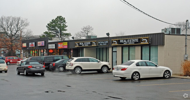
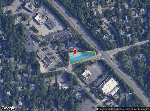
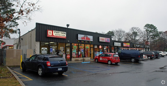
Property Record
411 Furrows Rd, Holbrook, NY 11741
NEARBY LISTINGS FOR SALE OR LEASE
Property Detail
411 Furrows Rd
Nassau County-Suffolk County, NY
Peter Duryea Tract
0500-067-00-02-00-021-000
X2256584Y213139 N031N00000000
Commercialnec
Suffolk
X
New York
36103C0690H
200
0
0.77 AC
2024
Central Suffolk
146613
Long Island (New York)
DEMOGRAPHICS near 411 Furrows Rd
1 Mile
3 Mile
5 Mile
2024 Total Population
9,623
79,529
227,870
2029 Population
9,442
78,512
224,703
Pop Growth 2024-2029
(1.88%)
(1.28%)
(1.39%)
Average Age
42
41
41
2024 Total Households
3,143
27,586
79,299
HH Growth 2024-2029
(2.10%)
(1.41%)
(1.55%)
Median Household Inc
$134,502
$119,396
$112,865
Avg Household Size
3.00
2.80
2.80
2024 Avg HH Vehicles
2.00
2.00
2.00
Median Home Value
$463,960
$444,250
$448,001
Median Year Built
1973
1973
1971
Nearby Places
- Restaurants
- Banks
- Shops
- Fitness
- Groceries
PUBLIC TRANSPORTATION
COMMUTER RAIL
Ronkonkoma Station (Greenport Branch - Long Island Rail Road, Ronkonkoma Branch - Long Island Rail Road)
DRIVE
WALK
Distance
Ronkonkoma Station (Greenport Branch - Long Island Rail Road, Ronkonkoma Branch - Long Island Rail Road)
5 min
2.1 mi
Medford Station (Greenport Branch - Long Island Rail Road)
DRIVE
WALK
Distance
Medford Station (Greenport Branch - Long Island Rail Road)
10 min
6.0 mi
AIRPORT
Long Island MacArthur
DRIVE
WALK
Distance
Long Island MacArthur
10 min
3.8 mi
Freight Ports
Port of New Haven
DRIVE
WALK
Distance
Port of New Haven
130 min
49.4 mi
Nearby Properties
Address
Land Use
TOTAL SIZE
Lot Size
Zoning
Address
Land Use
TOTAL SIZE
Lot Size
Zoning
1,207.60 AC
Address
Land Use
TOTAL SIZE
Lot Size
Zoning
30.25 AC
CA
Address
Land Use
TOTAL SIZE
Lot Size
Zoning
95.19 AC
Address
Land Use
TOTAL SIZE
Lot Size
Zoning
29.86 AC
CA
Address
Land Use
TOTAL SIZE
Lot Size
Zoning
26.28 AC
CA
Address
Land Use
TOTAL SIZE
Lot Size
Zoning
23.50 AC
AA
Address
Land Use
TOTAL SIZE
Lot Size
Zoning
26,811 SF
43.20 AC
CA
Address
Land Use
TOTAL SIZE
Lot Size
Zoning
18.68 AC
IND1
Address
Land Use
TOTAL SIZE
Lot Size
Zoning
96 SF
18.29 AC
BUS3
Address
Land Use
TOTAL SIZE
Lot Size
Zoning
3,025 SF
5.60 AC
AA
Address
Land Use
TOTAL SIZE
Lot Size
Zoning
12.70 AC
IND1
Address
Land Use
TOTAL SIZE
Lot Size
Zoning
5.01 AC
AA278
Address
Land Use
TOTAL SIZE
Lot Size
Zoning
42.37 AC
Address
Land Use
TOTAL SIZE
Lot Size
Zoning
140.10 AC
Address
Land Use
TOTAL SIZE
Lot Size
Zoning
12.14 AC
BUS3
Address
Land Use
TOTAL SIZE
Lot Size
Zoning
14.73 AC
AA
Address
Land Use
TOTAL SIZE
Lot Size
Zoning
11.19 AC
Address
Land Use
TOTAL SIZE
Lot Size
Zoning
16.90 AC
AA
Address
Land Use
TOTAL SIZE
Lot Size
Zoning
19.70 AC
AA
Address
Land Use
TOTAL SIZE
Lot Size
Zoning
5.40 AC
ICD
Address
Land Use
TOTAL SIZE
Lot Size
Zoning
14.70 AC
BUS3
Address
Land Use
TOTAL SIZE
Lot Size
Zoning
14.48 AC
IND1
Address
Land Use
TOTAL SIZE
Lot Size
Zoning
6.50 AC
GSE
Address
Land Use
TOTAL SIZE
Lot Size
Zoning
17.52 AC
ICD
Address
Land Use
TOTAL SIZE
Lot Size
Zoning
Address
Land Use
TOTAL SIZE
Lot Size
Zoning
26.18 AC
IND1
Address
Land Use
TOTAL SIZE
Lot Size
Zoning
14.75 AC
CA
Address
Land Use
TOTAL SIZE
Lot Size
Zoning
11.17 AC
Address
Land Use
TOTAL SIZE
Lot Size
Zoning
15.80 AC
ICD
Address
Land Use
TOTAL SIZE
Lot Size
Zoning
13.39 AC
C
The World's #1 Commercial Real Estate Marketplace
Connect with us
© 2025 CoStar Group
The information above has been obtained from sources believed reliable. While we do not doubt its accuracy we have not verified it and make no guarantee, warranty or representation about it. It is your responsibility to independently confirm its accuracy and completeness. Any projections, opinions, assumptions, or estimates used are for example only and do not represent the current or future performance of the property. The value of this transaction to you depends on tax and other factors which should be evaluated by your tax, financial, and legal advisors. You and your advisors should conduct a careful, independent investigation of the property to determine to your satisfaction the suitability of the property for your needs.