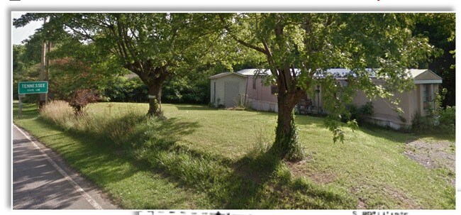
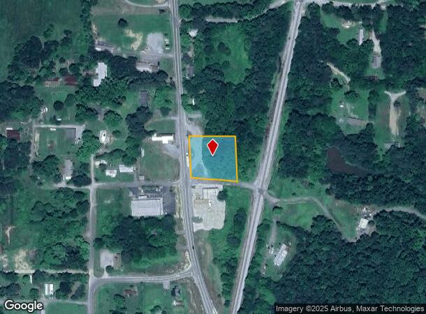
Property Record
411 N Highway, Tennga, GA 30751
NEARBY LISTINGS FOR SALE OR LEASE
-
-
View all Tennga listings for sale on LoopNet.com
Property Detail
411 N Highway
Dalton, GA
County Commercial
0057-079
TR 4 PLAT 41-4
Commercialacreage
Murray
X
Georgia
13213C0050D
0.89 AC
2024
Georgia Northwest
2024
Other Market Areas
010100
DEMOGRAPHICS near 411 N Highway
1 Mile
3 Mile
5 Mile
2024 Total Population
298
1,781
5,126
2029 Population
310
1,847
5,320
Pop Growth 2024-2029
+ 4.03%
+ 3.71%
+ 3.78%
Average Age
41
41
42
2024 Total Households
115
696
1,981
HH Growth 2024-2029
+ 4.35%
+ 3.74%
+ 3.79%
Median Household Inc
$43,055
$38,610
$47,300
Avg Household Size
2.50
2.50
2.50
2024 Avg HH Vehicles
2.00
2.00
2.00
Median Home Value
$93,877
$97,856
$123,736
Median Year Built
1983
1984
1987
Nearby Places
Map Layers
Map Styles
 Street
 Aerial
- Restaurants
- Banks
- Shops
- Fitness
- Groceries
PUBLIC TRANSPORTATION
AIRPORT
Lovell Field
DRIVE
WALK
Distance
Lovell Field
58 min
39.0 mi
SALE & LEASE HISTORY
LISTING DATE
SALE/LEASE

Mar 15, 2017
For Sale
Aug 24, 2017
For Sale
Aug 21, 2017
For Sale
Nearby Properties
Address
Land Use
TOTAL SIZE
Lot Size
Zoning
Address
Land Use
TOTAL SIZE
Lot Size
Zoning
1,658 AC
AG
Address
Land Use
TOTAL SIZE
Lot Size
Zoning
5,896 SF
216.19 AC
Address
Land Use
TOTAL SIZE
Lot Size
Zoning
Address
Land Use
TOTAL SIZE
Lot Size
Zoning
7,152 SF
36.37 AC
Address
Land Use
TOTAL SIZE
Lot Size
Zoning
4,432 SF
456.47 AC
Address
Land Use
TOTAL SIZE
Lot Size
Zoning
3,991 SF
22.82 AC
FAR
Address
Land Use
TOTAL SIZE
Lot Size
Zoning
1,513 SF
411.79 AC
Address
Land Use
TOTAL SIZE
Lot Size
Zoning
182.28 AC
SPLIT-ZONE
Address
Land Use
TOTAL SIZE
Lot Size
Zoning
7,642 SF
7.08 AC
SR
Address
Land Use
TOTAL SIZE
Lot Size
Zoning
5,339 SF
155.30 AC
FAR
Address
Land Use
TOTAL SIZE
Lot Size
Zoning
5,925 SF
3.18 AC
SR
Address
Land Use
TOTAL SIZE
Lot Size
Zoning
320 AC
AG
Address
Land Use
TOTAL SIZE
Lot Size
Zoning
1,072 SF
32 AC
AG
Address
Land Use
TOTAL SIZE
Lot Size
Zoning
5,114 SF
43.04 AC
FAR
Address
Land Use
TOTAL SIZE
Lot Size
Zoning
2,602 SF
251.66 AC
Address
Land Use
TOTAL SIZE
Lot Size
Zoning
56,788 SF
26 AC
Address
Land Use
TOTAL SIZE
Lot Size
Zoning
5,564 SF
22.06 AC
FAR
Address
Land Use
TOTAL SIZE
Lot Size
Zoning
82.24 AC
SPLIT-ZONE
Address
Land Use
TOTAL SIZE
Lot Size
Zoning
1,440 SF
90.96 AC
AG
Address
Land Use
TOTAL SIZE
Lot Size
Zoning
1,152 SF
101.30 AC
FAR
Address
Land Use
TOTAL SIZE
Lot Size
Zoning
121 AC
AG
Address
Land Use
TOTAL SIZE
Lot Size
Zoning
3,165 SF
58.50 AC
FAR
Address
Land Use
TOTAL SIZE
Lot Size
Zoning
4,848 SF
5.50 AC
SR
Address
Land Use
TOTAL SIZE
Lot Size
Zoning
2,520 SF
27 AC
Address
Land Use
TOTAL SIZE
Lot Size
Zoning
81.62 AC
AG
Address
Land Use
TOTAL SIZE
Lot Size
Zoning
3,404 SF
16.27 AC
Address
Land Use
TOTAL SIZE
Lot Size
Zoning
2,542 SF
30 AC
FAR
Address
Land Use
TOTAL SIZE
Lot Size
Zoning
4,086 SF
17.85 AC
Address
Land Use
TOTAL SIZE
Lot Size
Zoning
3,808 SF
33.70 AC
FAR
Address
Land Use
TOTAL SIZE
Lot Size
Zoning
The World's #1 Commercial Real Estate Marketplace
Connect with us
© 2025 CoStar Group
The information above has been obtained from sources believed reliable. While we do not doubt its accuracy we have not verified it and make no guarantee, warranty or representation about it. It is your responsibility to independently confirm its accuracy and completeness. Any projections, opinions, assumptions, or estimates used are for example only and do not represent the current or future performance of the property. The value of this transaction to you depends on tax and other factors which should be evaluated by your tax, financial, and legal advisors. You and your advisors should conduct a careful, independent investigation of the property to determine to your satisfaction the suitability of the property for your needs.