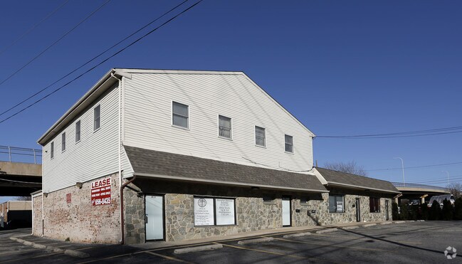
Property Record
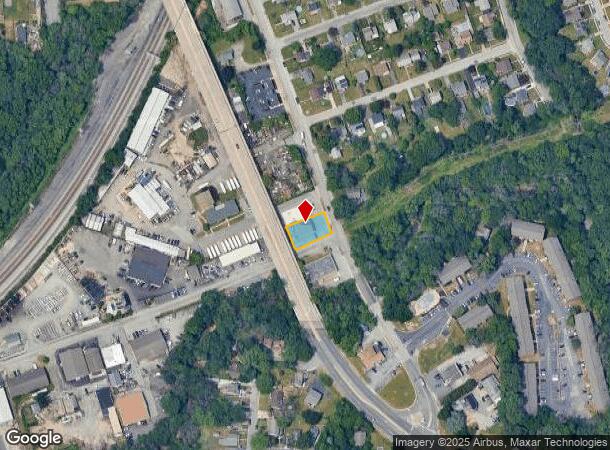
411 Old Dupont Rd, Wilmington, DE 19804

NEARBY LISTINGS FOR SALE OR LEASE
Property Detail
411 Old Dupont Rd
19-009.00-009
Medori Subd
Storebuilding
New Castle
AE
Delaware
10003C0152L
1
2024
0.21 AC
2024
South New Castle County
012400
Philadelphia
4,601 SF
Philadelphia-Camden-Wilmington, PA-NJ-DE-MD
DEMOGRAPHICS near 411 Old Dupont Rd
1 Mile
3 Mile
5 Mile
2024 Total Population
21,345
113,669
196,004
2029 Population
21,619
116,230
199,630
Pop Growth 2024-2029
+ 1.28%
+ 2.25%
+ 1.85%
Average Age
38
39
41
2024 Total Households
8,467
47,399
80,025
HH Growth 2024-2029
+ 1.32%
+ 2.34%
+ 1.92%
Median Household Inc
$56,320
$55,192
$61,348
Avg Household Size
2.50
2.30
2.40
2024 Avg HH Vehicles
2.00
1.00
2.00
Median Home Value
$193,300
$227,639
$243,404
Median Year Built
1952
1953
1957
Nearby Places
Map Layers
Map Styles
 Street
 Aerial
- Restaurants
- Banks
- Shops
- Fitness
- Groceries
PUBLIC TRANSPORTATION
AIRPORT
Philadelphia International
DRIVE
WALK
Distance
Philadelphia International
34 min
23.2 mi
Freight Ports
Port of Wilmington, RI
DRIVE
WALK
Distance
Port of Wilmington, RI
1 min
3.7 mi
SALE & LEASE HISTORY
LISTING DATE
SALE/LEASE

Sep 25, 2016
For Lease
Nearby Properties
Address
Land Use
TOTAL SIZE
Lot Size
Zoning
Address
Land Use
TOTAL SIZE
Lot Size
Zoning
819,930 SF
78.51 AC
HI
Address
Land Use
TOTAL SIZE
Lot Size
Zoning
45,956 SF
1.05 AC
26C-4
Address
Land Use
TOTAL SIZE
Lot Size
Zoning
202,328 SF
10.98 AC
26R5-C
Address
Land Use
TOTAL SIZE
Lot Size
Zoning
679,619 SF
5.91 AC
26R-3
Address
Land Use
TOTAL SIZE
Lot Size
Zoning
624,255 SF
132.95 AC
SR
Address
Land Use
TOTAL SIZE
Lot Size
Zoning
347,001 SF
1.06 AC
26C-4
Address
Land Use
TOTAL SIZE
Lot Size
Zoning
191,280 SF
2.05 AC
26R-3
Address
Land Use
TOTAL SIZE
Lot Size
Zoning
20,000 SF
1.26 AC
26C-4
Address
Land Use
TOTAL SIZE
Lot Size
Zoning
593,288 SF
20.38 AC
OR
Address
Land Use
TOTAL SIZE
Lot Size
Zoning
145,000 SF
0.97 AC
26C-4
Address
Land Use
TOTAL SIZE
Lot Size
Zoning
234,457 SF
18.18 AC
26R-3
Address
Land Use
TOTAL SIZE
Lot Size
Zoning
7,840 SF
3.82 AC
26C-4
Address
Land Use
TOTAL SIZE
Lot Size
Zoning
356,859 SF
55.73 AC
OR
Address
Land Use
TOTAL SIZE
Lot Size
Zoning
38,140 SF
1.15 AC
26C-4
Address
Land Use
TOTAL SIZE
Lot Size
Zoning
43,325 SF
2.69 AC
26C-4
Address
Land Use
TOTAL SIZE
Lot Size
Zoning
406,158 SF
1.29 AC
26C-4
Address
Land Use
TOTAL SIZE
Lot Size
Zoning
332,844 SF
2.15 AC
26C-4
Address
Land Use
TOTAL SIZE
Lot Size
Zoning
410,310 SF
1.27 AC
26R-3
Address
Land Use
TOTAL SIZE
Lot Size
Zoning
107,072 SF
0.76 AC
26C-2
Address
Land Use
TOTAL SIZE
Lot Size
Zoning
80,500 SF
97.08 AC
S
Address
Land Use
TOTAL SIZE
Lot Size
Zoning
301,712 SF
0.92 AC
26C-4
Address
Land Use
TOTAL SIZE
Lot Size
Zoning
472,000 SF
1.05 AC
26C-4
Address
Land Use
TOTAL SIZE
Lot Size
Zoning
2,864 SF
1.02 AC
26C-4
Address
Land Use
TOTAL SIZE
Lot Size
Zoning
96,252 SF
1.50 AC
26R-2
Address
Land Use
TOTAL SIZE
Lot Size
Zoning
871,571 SF
59.53 AC
OR
Address
Land Use
TOTAL SIZE
Lot Size
Zoning
116,042 SF
108.83 AC
SR
Address
Land Use
TOTAL SIZE
Lot Size
Zoning
266,847 SF
26C-4
Address
Land Use
TOTAL SIZE
Lot Size
Zoning
89,500 SF
1.81 AC
26C-4
Address
Land Use
TOTAL SIZE
Lot Size
Zoning
119,886 SF
3.81 AC
26R-3
Address
Land Use
TOTAL SIZE
Lot Size
Zoning
51,360 SF
1.52 AC
26R5-B
The World's #1 Commercial Real Estate Marketplace
Connect with us
© 2025 CoStar Group
The information above has been obtained from sources believed reliable. While we do not doubt its accuracy we have not verified it and make no guarantee, warranty or representation about it. It is your responsibility to independently confirm its accuracy and completeness. Any projections, opinions, assumptions, or estimates used are for example only and do not represent the current or future performance of the property. The value of this transaction to you depends on tax and other factors which should be evaluated by your tax, financial, and legal advisors. You and your advisors should conduct a careful, independent investigation of the property to determine to your satisfaction the suitability of the property for your needs.