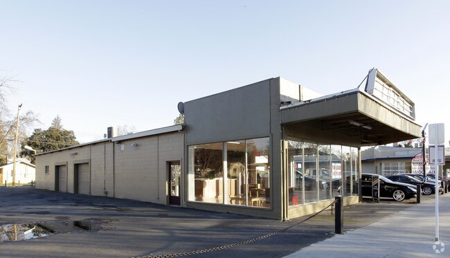
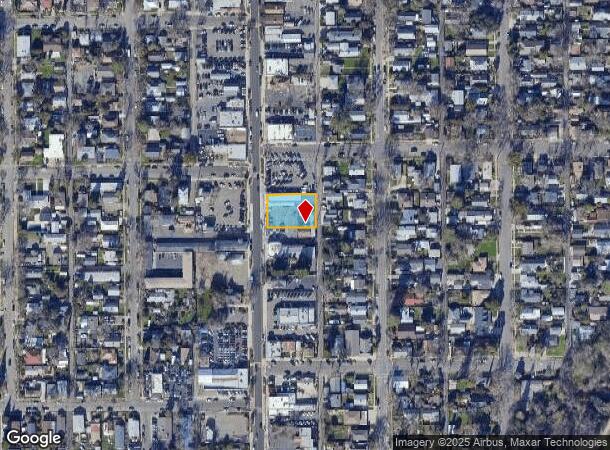
Property Record
411 Riverside Ave, Roseville, CA 95678
NEARBY LISTINGS FOR SALE OR LEASE
Property Detail
411 Riverside Ave
Sacramento--Roseville--Arden-Arcade, CA
Cherry
014-191-022
LOTS 3 4 CHERRY GL TR
Vehiclerentalsvehiclesales
Placer
X
California
06061C1031H
3
2024
0.34 AC
2025
Roseville/Rocklin
020901
Sacramento
2,788 SF
DEMOGRAPHICS near 411 Riverside Ave
1 Mile
3 Mile
5 Mile
2024 Total Population
14,039
111,493
328,855
2029 Population
15,008
116,865
342,189
Pop Growth 2024-2029
+ 6.90%
+ 4.82%
+ 4.05%
Average Age
40
40
40
2024 Total Households
5,614
42,578
122,229
HH Growth 2024-2029
+ 6.93%
+ 4.97%
+ 4.16%
Median Household Inc
$70,331
$87,109
$90,400
Avg Household Size
2.40
2.60
2.60
2024 Avg HH Vehicles
2.00
2.00
2.00
Median Home Value
$383,647
$470,871
$492,488
Median Year Built
1973
1983
1987
Nearby Places
Map Layers
Map Styles
 Street
 Aerial
- Restaurants
- Banks
- Shops
- Fitness
- Groceries
PUBLIC TRANSPORTATION
COMMUTER RAIL
Roseville (California Zephyr - Amtrak, Capitol Corridor - Amtrak)
DRIVE
WALK
Distance
Roseville (California Zephyr - Amtrak, Capitol Corridor - Amtrak)
5 min
19 min
1.0 mi
Rocklin Amtrak Station (Capitol Corridor - Amtrak)
DRIVE
WALK
Distance
Rocklin Amtrak Station (Capitol Corridor - Amtrak)
11 min
5.6 mi
AIRPORT
Sacramento International
DRIVE
WALK
Distance
Sacramento International
33 min
23.8 mi
Freight Ports
Port of Stockton
DRIVE
WALK
Distance
Port of Stockton
75 min
64.0 mi
SALE & LEASE HISTORY
LISTING DATE
SALE/LEASE

Apr 27, 2024
For Lease
Nearby Properties
Address
Land Use
TOTAL SIZE
Lot Size
Zoning
Address
Land Use
TOTAL SIZE
Lot Size
Zoning
1,444,630 SF
53.20 AC
Address
Land Use
TOTAL SIZE
Lot Size
Zoning
678,494 SF
15.80 AC
Address
Land Use
TOTAL SIZE
Lot Size
Zoning
350,573 SF
26.30 AC
Address
Land Use
TOTAL SIZE
Lot Size
Zoning
277,602 SF
26.49 AC
Address
Land Use
TOTAL SIZE
Lot Size
Zoning
210,380 SF
14.26 AC
Address
Land Use
TOTAL SIZE
Lot Size
Zoning
280,129 SF
14.90 AC
Address
Land Use
TOTAL SIZE
Lot Size
Zoning
325,462 SF
29.50 AC
Address
Land Use
TOTAL SIZE
Lot Size
Zoning
328,416 SF
17.80 AC
Address
Land Use
TOTAL SIZE
Lot Size
Zoning
105,730 SF
7.20 AC
Address
Land Use
TOTAL SIZE
Lot Size
Zoning
174,840 SF
19.70 AC
Address
Land Use
TOTAL SIZE
Lot Size
Zoning
144,760 SF
26.70 AC
Address
Land Use
TOTAL SIZE
Lot Size
Zoning
222,702 SF
10.57 AC
Address
Land Use
TOTAL SIZE
Lot Size
Zoning
132,784 SF
9.80 AC
Address
Land Use
TOTAL SIZE
Lot Size
Zoning
233,228 SF
12.10 AC
Address
Land Use
TOTAL SIZE
Lot Size
Zoning
288,628 SF
11.90 AC
Address
Land Use
TOTAL SIZE
Lot Size
Zoning
143,809 SF
14.40 AC
Address
Land Use
TOTAL SIZE
Lot Size
Zoning
263,682 SF
14.40 AC
Address
Land Use
TOTAL SIZE
Lot Size
Zoning
718,131 SF
42 AC
Address
Land Use
TOTAL SIZE
Lot Size
Zoning
310,720 SF
16.90 AC
Address
Land Use
TOTAL SIZE
Lot Size
Zoning
121,000 SF
17.20 AC
Address
Land Use
TOTAL SIZE
Lot Size
Zoning
78,730 SF
8.03 AC
RD20 BP
Address
Land Use
TOTAL SIZE
Lot Size
Zoning
82,661 SF
7.50 AC
Address
Land Use
TOTAL SIZE
Lot Size
Zoning
128,480 SF
7.95 AC
RD30 BP
Address
Land Use
TOTAL SIZE
Lot Size
Zoning
220,000 SF
10 AC
Address
Land Use
TOTAL SIZE
Lot Size
Zoning
119,417 SF
11 AC
Address
Land Use
TOTAL SIZE
Lot Size
Zoning
2,080 SF
136.17 AC
FDR
Address
Land Use
TOTAL SIZE
Lot Size
Zoning
126,521 SF
11 AC
Address
Land Use
TOTAL SIZE
Lot Size
Zoning
110,744 SF
6.70 AC
Address
Land Use
TOTAL SIZE
Lot Size
Zoning
98,508 SF
5.33 AC
RD20
Address
Land Use
TOTAL SIZE
Lot Size
Zoning
109,098 SF
5.50 AC
The World's #1 Commercial Real Estate Marketplace
Connect with us
© 2025 CoStar Group
The information above has been obtained from sources believed reliable. While we do not doubt its accuracy we have not verified it and make no guarantee, warranty or representation about it. It is your responsibility to independently confirm its accuracy and completeness. Any projections, opinions, assumptions, or estimates used are for example only and do not represent the current or future performance of the property. The value of this transaction to you depends on tax and other factors which should be evaluated by your tax, financial, and legal advisors. You and your advisors should conduct a careful, independent investigation of the property to determine to your satisfaction the suitability of the property for your needs.