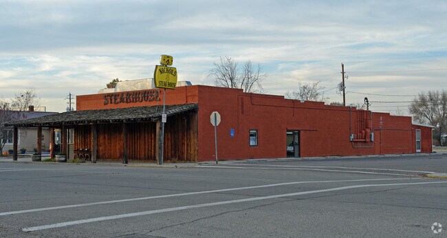
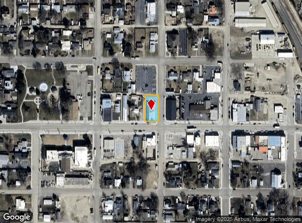
Property Record
411 Sw 3Rd St, Fruitland, ID 83619

NEARBY LISTINGS FOR SALE OR LEASE
Property Detail
411 Sw 3Rd St
Other Market Areas
Original Townsite Of Fruitland
Ontario, OR-ID
LOTS 7-8-9, BLK 11 FRUITLAND ORIGINAL
F3300011007A
Payette
Restaurantbuilding
Idaho
2025
7-8
2025
0.25 AC
960302
Idaho South Area
5,150 SF
DEMOGRAPHICS near 411 Sw 3Rd St
1 Mile
3 Mile
5 Mile
2024 Total Population
3,735
14,195
29,887
2029 Population
4,377
15,954
33,166
Pop Growth 2024-2029
+ 17.19%
+ 12.39%
+ 10.97%
Average Age
39
37
39
2024 Total Households
1,352
5,080
11,106
HH Growth 2024-2029
+ 17.53%
+ 12.81%
+ 11.27%
Median Household Inc
$75,483
$57,738
$52,808
Avg Household Size
2.70
2.70
2.60
2024 Avg HH Vehicles
2.00
2.00
2.00
Median Home Value
$310,682
$235,220
$232,249
Median Year Built
1987
1978
1977
Nearby Places
Map Layers
Map Styles
 Street
 Aerial
- Restaurants
- Banks
- Shops
- Fitness
- Groceries
SALE & LEASE HISTORY
LISTING DATE
SALE/LEASE

Sep 22, 2019
For Sale
Nearby Properties
Address
Land Use
TOTAL SIZE
Lot Size
Zoning
Address
Land Use
TOTAL SIZE
Lot Size
Zoning
50.97 AC
O-I2
Address
Land Use
TOTAL SIZE
Lot Size
Zoning
10 SF
89.11 AC
O-CD
Address
Land Use
TOTAL SIZE
Lot Size
Zoning
10 SF
6.75 AC
O-PF
Address
Land Use
TOTAL SIZE
Lot Size
Zoning
35.92 AC
Address
Land Use
TOTAL SIZE
Lot Size
Zoning
4.74 AC
O-PF
Address
Land Use
TOTAL SIZE
Lot Size
Zoning
50.97 AC
O-I2
Address
Land Use
TOTAL SIZE
Lot Size
Zoning
10 SF
6.57 AC
O-CD
Address
Land Use
TOTAL SIZE
Lot Size
Zoning
36,732 SF
7.14 AC
O-CD
Address
Land Use
TOTAL SIZE
Lot Size
Zoning
4.96 AC
O-C2
Address
Land Use
TOTAL SIZE
Lot Size
Zoning
197,522 SF
19.72 AC
O-C2
Address
Land Use
TOTAL SIZE
Lot Size
Zoning
71,504 SF
5.94 AC
Address
Land Use
TOTAL SIZE
Lot Size
Zoning
10.89 AC
INDUSTRIAL
Address
Land Use
TOTAL SIZE
Lot Size
Zoning
104,456 SF
8.71 AC
O-C2H
Address
Land Use
TOTAL SIZE
Lot Size
Zoning
42,807 SF
11.02 AC
Address
Land Use
TOTAL SIZE
Lot Size
Zoning
21,715 SF
4.94 AC
Address
Land Use
TOTAL SIZE
Lot Size
Zoning
39,162 SF
3.95 AC
Address
Land Use
TOTAL SIZE
Lot Size
Zoning
9.69 AC
INDUSTRIAL
Address
Land Use
TOTAL SIZE
Lot Size
Zoning
141.70 AC
O-I2
Address
Land Use
TOTAL SIZE
Lot Size
Zoning
65,953 SF
4.77 AC
COMMERCIAL
Address
Land Use
TOTAL SIZE
Lot Size
Zoning
Address
Land Use
TOTAL SIZE
Lot Size
Zoning
62,348 SF
2.24 AC
O-C2
Address
Land Use
TOTAL SIZE
Lot Size
Zoning
26,855 SF
1.85 AC
Address
Land Use
TOTAL SIZE
Lot Size
Zoning
48,892 SF
5.76 AC
O-C2H
Address
Land Use
TOTAL SIZE
Lot Size
Zoning
18.67 AC
Address
Land Use
TOTAL SIZE
Lot Size
Zoning
10.83 AC
COMMERCIAL
Address
Land Use
TOTAL SIZE
Lot Size
Zoning
1.53 AC
O-I2
Address
Land Use
TOTAL SIZE
Lot Size
Zoning
41.81 AC
O-I2+
Address
Land Use
TOTAL SIZE
Lot Size
Zoning
79,686 SF
5.79 AC
INDUSTRIAL
Address
Land Use
TOTAL SIZE
Lot Size
Zoning
10,644 SF
2.96 AC
O-PF
Address
Land Use
TOTAL SIZE
Lot Size
Zoning
1,800 SF
4.09 AC
The World's #1 Commercial Real Estate Marketplace
Connect with us
© 2025 CoStar Group
The information above has been obtained from sources believed reliable. While we do not doubt its accuracy we have not verified it and make no guarantee, warranty or representation about it. It is your responsibility to independently confirm its accuracy and completeness. Any projections, opinions, assumptions, or estimates used are for example only and do not represent the current or future performance of the property. The value of this transaction to you depends on tax and other factors which should be evaluated by your tax, financial, and legal advisors. You and your advisors should conduct a careful, independent investigation of the property to determine to your satisfaction the suitability of the property for your needs.