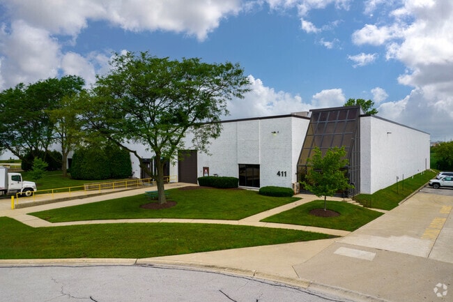
Property Record
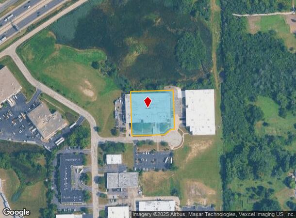
411 W Heathrow Ct, Burr Ridge, IL 60527


NEARBY LISTINGS FOR SALE OR LEASE
Property Detail
411 W Heathrow Ct
Chicago-Naperville-Elgin, IL-IN-WI
Burr Ridge Industrial Common
09-25-303-004
BURR RIDGE INDUSTRIAL COMMON ALL
Industrialgeneral
DuPage
X
Illinois
17043C0281J
19
2024
1.53 AC
2024
South I-55 Corridor
845902
Chicago
45,609 SF
DEMOGRAPHICS near 411 W Heathrow Ct
1 Mile
3 Mile
5 Mile
2024 Total Population
3,578
67,346
186,367
2029 Population
3,544
66,432
183,571
Pop Growth 2024-2029
(0.95%)
(1.36%)
(1.50%)
Average Age
48
44
42
2024 Total Households
1,361
27,396
71,072
HH Growth 2024-2029
(1.18%)
(1.51%)
(1.68%)
Median Household Inc
$140,659
$104,344
$105,636
Avg Household Size
2.60
2.40
2.60
2024 Avg HH Vehicles
2.00
2.00
2.00
Median Home Value
$646,691
$408,374
$420,381
Median Year Built
1986
1977
1975
Nearby Places
Map Layers
Map Styles
 Street
 Aerial
- Restaurants
- Banks
- Shops
- Fitness
- Groceries
SALE & LEASE HISTORY
LISTING DATE
SALE/LEASE

Sep 02, 2022
For Lease
Nov 26, 2019
For Lease
Nov 24, 2020
For Lease
May 24, 2018
For Lease
Nearby Properties
Address
Land Use
TOTAL SIZE
Lot Size
Zoning
Address
Land Use
TOTAL SIZE
Lot Size
Zoning
96.60 AC
Address
Land Use
TOTAL SIZE
Lot Size
Zoning
183,080 SF
20.86 AC
C
Address
Land Use
TOTAL SIZE
Lot Size
Zoning
204,824 SF
15.05 AC
Address
Land Use
TOTAL SIZE
Lot Size
Zoning
368,233 SF
16.12 AC
Address
Land Use
TOTAL SIZE
Lot Size
Zoning
388,561 SF
12.77 AC
Address
Land Use
TOTAL SIZE
Lot Size
Zoning
68.06 AC
Address
Land Use
TOTAL SIZE
Lot Size
Zoning
274,406 SF
17.67 AC
M
Address
Land Use
TOTAL SIZE
Lot Size
Zoning
436,456 SF
59.11 AC
I
Address
Land Use
TOTAL SIZE
Lot Size
Zoning
182,295 SF
21.84 AC
C
Address
Land Use
TOTAL SIZE
Lot Size
Zoning
230,187 SF
15.38 AC
M
Address
Land Use
TOTAL SIZE
Lot Size
Zoning
202,562 SF
16.17 AC
M
Address
Land Use
TOTAL SIZE
Lot Size
Zoning
104,912 SF
6.91 AC
Address
Land Use
TOTAL SIZE
Lot Size
Zoning
94,064 SF
8.55 AC
Address
Land Use
TOTAL SIZE
Lot Size
Zoning
110,584 SF
5.57 AC
Address
Land Use
TOTAL SIZE
Lot Size
Zoning
203,532 SF
6.85 AC
M
Address
Land Use
TOTAL SIZE
Lot Size
Zoning
146,856 SF
7.18 AC
A
Address
Land Use
TOTAL SIZE
Lot Size
Zoning
111,892 SF
8.69 AC
I
Address
Land Use
TOTAL SIZE
Lot Size
Zoning
113,961 SF
6.94 AC
M
Address
Land Use
TOTAL SIZE
Lot Size
Zoning
195,000 SF
10.18 AC
Address
Land Use
TOTAL SIZE
Lot Size
Zoning
49,503 SF
1.47 AC
Address
Land Use
TOTAL SIZE
Lot Size
Zoning
215,631 SF
23.94 AC
I
Address
Land Use
TOTAL SIZE
Lot Size
Zoning
84,944 SF
6.82 AC
C
Address
Land Use
TOTAL SIZE
Lot Size
Zoning
289,314 SF
2.79 AC
Address
Land Use
TOTAL SIZE
Lot Size
Zoning
128,283 SF
6.89 AC
C
Address
Land Use
TOTAL SIZE
Lot Size
Zoning
52,887 SF
4.64 AC
C
Address
Land Use
TOTAL SIZE
Lot Size
Zoning
144,840 SF
3.42 AC
Address
Land Use
TOTAL SIZE
Lot Size
Zoning
70,031 SF
3.87 AC
C
Address
Land Use
TOTAL SIZE
Lot Size
Zoning
188,319 SF
10.09 AC
M
Address
Land Use
TOTAL SIZE
Lot Size
Zoning
129,195 SF
10.71 AC
Address
Land Use
TOTAL SIZE
Lot Size
Zoning
The World's #1 Commercial Real Estate Marketplace
Connect with us
© 2025 CoStar Group
The information above has been obtained from sources believed reliable. While we do not doubt its accuracy we have not verified it and make no guarantee, warranty or representation about it. It is your responsibility to independently confirm its accuracy and completeness. Any projections, opinions, assumptions, or estimates used are for example only and do not represent the current or future performance of the property. The value of this transaction to you depends on tax and other factors which should be evaluated by your tax, financial, and legal advisors. You and your advisors should conduct a careful, independent investigation of the property to determine to your satisfaction the suitability of the property for your needs.