Property Record
411 W Main St, Avon, CT 06001


This Property Is For Sale
Property Detail
411 W Main St
AVON-000006-000000-000454-000411
HARTFORD
Commercialbuilding
Connecticut
CR
4540411
B and X Area of moderate flood hazard, usually the area between the limits of the 100-year and 500-year floods.
0.43 AC
2025
Avon
2025
Hartford
462201
Hartford-West Hartford-East Hartford, CT
NEARBY LISTINGS FOR SALE OR LEASE
DEMOGRAPHICS near 411 W Main St
1 mile
3 mile
5 mile
2025 Total Population
2,815
27,300
53,214
2030 Population
2,877
27,977
54,474
Pop Growth 2025-2030
+ 2.20%
+ 2.48%
+ 2.37%
Average Age
43
43
43
2025 Total Households
1,082
10,502
21,058
HH Growth 2025-2030
+ 2.31%
+ 2.51%
+ 2.43%
Median Household Inc
$140,691
$141,038
$144,384
Avg Household Size
2.50
2.50
2.50
2025 Avg HH Vehicles
2.00
2.00
2.00
Median Home Value
$425,597
$457,150
$446,297
Median Year Built
1975
1975
1976
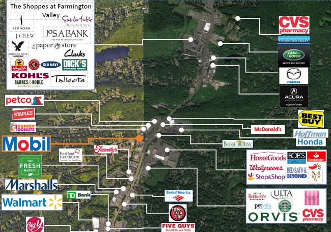
Nearby Places
Map Layers
Map Styles
 Street
 Aerial
Layers
 Traffic
 Biking
Places
Listings with unknown addresses are not visible on the map
- Restaurants
- Banks
- Shops
- Fitness
- Groceries
PUBLIC TRANSPORTATION
AIRPORT
Bradley International
Drive
Walk
Distance
Bradley International
39 min
18.7 mi
Nearby Properties
Address
Land Use
TOTAL SIZE
Lot Size
Zoning
Address
Land Use
TOTAL SIZE
Lot Size
Zoning
39.86 AC
R40
Address
Land Use
TOTAL SIZE
Lot Size
Zoning
124 AC
B
Address
Land Use
TOTAL SIZE
Lot Size
Zoning
26,928 SF
14.77 AC
PAD
Address
Land Use
TOTAL SIZE
Lot Size
Zoning
172,502 SF
28.04 AC
MCPF
Address
Land Use
TOTAL SIZE
Lot Size
Zoning
16.40 AC
B-3
Address
Land Use
TOTAL SIZE
Lot Size
Zoning
49,881 SF
18 AC
R-40
Address
Land Use
TOTAL SIZE
Lot Size
Zoning
18.52 AC
R40
Address
Land Use
TOTAL SIZE
Lot Size
Zoning
21.24 AC
R40
Address
Land Use
TOTAL SIZE
Lot Size
Zoning
5,640 SF
106.10 AC
R-40
Address
Land Use
TOTAL SIZE
Lot Size
Zoning
46.60 AC
RU2A
Address
Land Use
TOTAL SIZE
Lot Size
Zoning
21.86 AC
Address
Land Use
TOTAL SIZE
Lot Size
Zoning
20 AC
R30
Address
Land Use
TOTAL SIZE
Lot Size
Zoning
18.05 AC
CR
Address
Land Use
TOTAL SIZE
Lot Size
Zoning
10.91 AC
AVC
Address
Land Use
TOTAL SIZE
Lot Size
Zoning
13.08 AC
CR
Address
Land Use
TOTAL SIZE
Lot Size
Zoning
21.06 AC
B-3
Address
Land Use
TOTAL SIZE
Lot Size
Zoning
112,351 SF
27.57 AC
RD
Address
Land Use
TOTAL SIZE
Lot Size
Zoning
64,974 SF
B
Address
Land Use
TOTAL SIZE
Lot Size
Zoning
70,929 SF
12.47 AC
MCPF
Address
Land Use
TOTAL SIZE
Lot Size
Zoning
5.12 AC
Address
Land Use
TOTAL SIZE
Lot Size
Zoning
10 AC
RU2A
Address
Land Use
TOTAL SIZE
Lot Size
Zoning
6.57 AC
IP
Address
Land Use
TOTAL SIZE
Lot Size
Zoning
14,299 SF
6.64 AC
MCPF
Address
Land Use
TOTAL SIZE
Lot Size
Zoning
64,948 SF
9 AC
B-3
Address
Land Use
TOTAL SIZE
Lot Size
Zoning
20.11 AC
Address
Land Use
TOTAL SIZE
Lot Size
Zoning
4.02 AC
CP-A
Address
Land Use
TOTAL SIZE
Lot Size
Zoning
3.80 AC
Address
Land Use
TOTAL SIZE
Lot Size
Zoning
57,104 SF
7.71 AC
MCPF
Address
Land Use
TOTAL SIZE
Lot Size
Zoning
15.90 AC
R40
Address
Land Use
TOTAL SIZE
Lot Size
Zoning
126,889 SF
13.73 AC
I-1
The World's #1 Commercial Real Estate Marketplace
Connect with us
© 2026 CoStar Group
The information above has been obtained from sources believed reliable. While we do not doubt its accuracy we have not verified it and make no guarantee, warranty or representation about it. It is your responsibility to independently confirm its accuracy and completeness. Any projections, opinions, assumptions, or estimates used are for example only and do not represent the current or future performance of the property. The value of this transaction to you depends on tax and other factors which should be evaluated by your tax, financial, and legal advisors. You and your advisors should conduct a careful, independent investigation of the property to determine to your satisfaction the suitability of the property for your needs.