Property Record
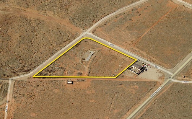
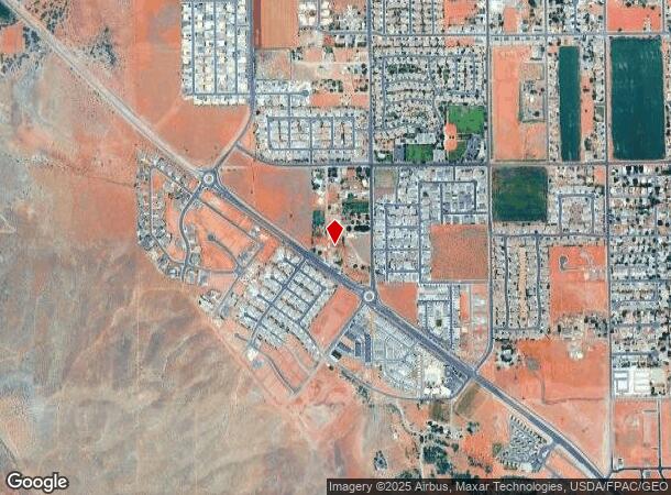
411 W Old Highway 91, Ivins, UT 84738
NEARBY LISTINGS FOR SALE OR LEASE
Property Detail
411 W Old Highway 91
St. George, UT
Kirkham Berry Addition
0197346
S: 6 T: 42S R: 16W PORTION OF THE SOUTHEAST QUARTER OF THE SOUTHWEST QUARTER OF SECTION 6, TOWNSHIP 42 SOUTH, RANGE 16 WEST, SALT LAKE BASE AND MERIDIAN, LYING NORTH OF THE RIGHT OF WAY LINES OF NORMANDY ROAD AND EAST OF GUY LANE, AS SHOWN ON THE ROA
Agriculturalland
Washington
X
Utah
49053C0765G
7
2024
1.62 AC
2025
Cedar City & St George
270401
Other Market Areas
1,152 SF
DEMOGRAPHICS near 411 W Old Highway 91
1 Mile
3 Mile
5 Mile
2024 Total Population
4,410
17,593
39,038
2029 Population
5,497
21,943
48,599
Pop Growth 2024-2029
+ 24.65%
+ 24.73%
+ 24.49%
Average Age
42
44
43
2024 Total Households
1,581
6,247
14,064
HH Growth 2024-2029
+ 25.24%
+ 25.42%
+ 25.21%
Median Household Inc
$59,260
$77,209
$74,382
Avg Household Size
2.80
2.80
2.70
2024 Avg HH Vehicles
2.00
2.00
2.00
Median Home Value
$451,249
$478,035
$463,450
Median Year Built
2003
2003
2000
Nearby Places
Map Layers
Map Styles
 Street
 Aerial
- Restaurants
- Banks
- Shops
- Fitness
- Groceries
PUBLIC TRANSPORTATION
AIRPORT
St George Regional
DRIVE
WALK
Distance
St George Regional
18 min
8.5 mi
Freight Ports
Port of Long Beach
DRIVE
WALK
Distance
Port of Long Beach
456 min
408.9 mi
Nearby Properties
Address
Land Use
TOTAL SIZE
Lot Size
Zoning
Address
Land Use
TOTAL SIZE
Lot Size
Zoning
103,871 SF
9.27 AC
Address
Land Use
TOTAL SIZE
Lot Size
Zoning
165,694 SF
70.03 AC
Address
Land Use
TOTAL SIZE
Lot Size
Zoning
101,652 SF
10.53 AC
Address
Land Use
TOTAL SIZE
Lot Size
Zoning
137,941 SF
4.75 AC
Address
Land Use
TOTAL SIZE
Lot Size
Zoning
87,138 SF
19.01 AC
Address
Land Use
TOTAL SIZE
Lot Size
Zoning
75,120 SF
7.37 AC
Address
Land Use
TOTAL SIZE
Lot Size
Zoning
198,324 SF
4.55 AC
Address
Land Use
TOTAL SIZE
Lot Size
Zoning
87,781 SF
16.02 AC
Address
Land Use
TOTAL SIZE
Lot Size
Zoning
66,280 SF
6.72 AC
Address
Land Use
TOTAL SIZE
Lot Size
Zoning
33,602 SF
1.10 AC
Address
Land Use
TOTAL SIZE
Lot Size
Zoning
44,696 SF
3.58 AC
Address
Land Use
TOTAL SIZE
Lot Size
Zoning
2,061 SF
33.58 AC
Address
Land Use
TOTAL SIZE
Lot Size
Zoning
41,072 SF
6.53 AC
Address
Land Use
TOTAL SIZE
Lot Size
Zoning
10,072 SF
26.08 AC
Address
Land Use
TOTAL SIZE
Lot Size
Zoning
12,312 SF
4.56 AC
Address
Land Use
TOTAL SIZE
Lot Size
Zoning
24,939 SF
1.96 AC
C-1
Address
Land Use
TOTAL SIZE
Lot Size
Zoning
36,893 SF
3.92 AC
PD
Address
Land Use
TOTAL SIZE
Lot Size
Zoning
22,930 SF
2.18 AC
Address
Land Use
TOTAL SIZE
Lot Size
Zoning
17,964 SF
2.56 AC
Address
Land Use
TOTAL SIZE
Lot Size
Zoning
16,551 SF
3.65 AC
Address
Land Use
TOTAL SIZE
Lot Size
Zoning
10,085 SF
0.33 AC
Address
Land Use
TOTAL SIZE
Lot Size
Zoning
10,085 SF
0.33 AC
Address
Land Use
TOTAL SIZE
Lot Size
Zoning
7,295 SF
21.71 AC
OSC20
Address
Land Use
TOTAL SIZE
Lot Size
Zoning
73,618 SF
4.61 AC
A20
Address
Land Use
TOTAL SIZE
Lot Size
Zoning
12,154 SF
0.40 AC
Address
Land Use
TOTAL SIZE
Lot Size
Zoning
70,464 SF
3.29 AC
Address
Land Use
TOTAL SIZE
Lot Size
Zoning
10,223 SF
0.33 AC
Address
Land Use
TOTAL SIZE
Lot Size
Zoning
1,147 SF
154.48 AC
The World's #1 Commercial Real Estate Marketplace
Connect with us
© 2026 CoStar Group
The information above has been obtained from sources believed reliable. While we do not doubt its accuracy we have not verified it and make no guarantee, warranty or representation about it. It is your responsibility to independently confirm its accuracy and completeness. Any projections, opinions, assumptions, or estimates used are for example only and do not represent the current or future performance of the property. The value of this transaction to you depends on tax and other factors which should be evaluated by your tax, financial, and legal advisors. You and your advisors should conduct a careful, independent investigation of the property to determine to your satisfaction the suitability of the property for your needs.