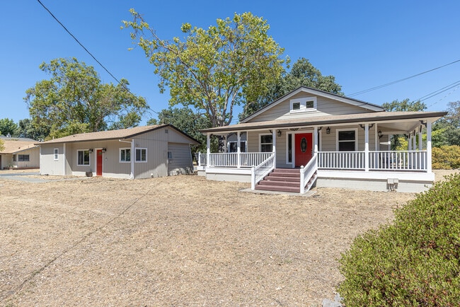
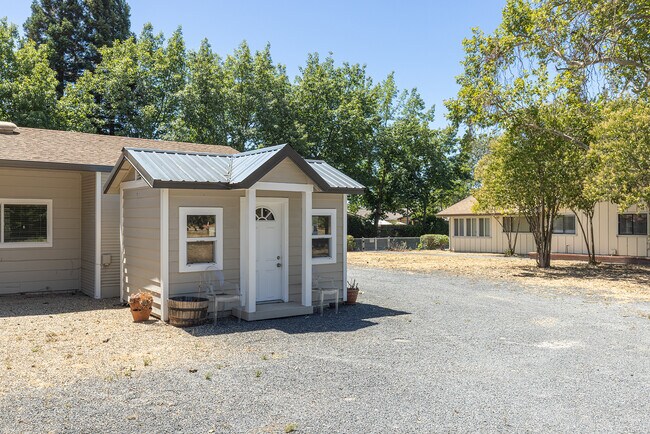
Property Record
411 Walten Way, Windsor, CA 95492

Save to a Folder
{{folder.Name}}
{{folder.ListingIds.length}} Properties
{{folder.ListingIds.length}} Property
Create a New Folder
Property Detail
411 Walten Way
161-060-055
2003 FM PT 161-060-037 2002R023204
Multifamilydwelling
Sonoma
B and X Area of moderate flood hazard, usually the area between the limits of the 100-year and 500-year floods.
California
2025
0.71 AC
2025
Windsor
153808
North Bay/Santa Rosa
1,980 SF
Santa Rosa-Petaluma, CA
NEARBY LISTINGS FOR SALE OR LEASE
DEMOGRAPHICS near 411 Walten Way
1 mile
3 mile
5 mile
2025 Total Population
13,484
28,212
41,512
2030 Population
13,493
28,122
41,406
Pop Growth 2025-2030
+ 0.07%
(0.32%)
(0.26%)
Average Age
42
43
44
2025 Total Households
4,548
9,751
15,212
HH Growth 2025-2030
(0.15%)
(0.48%)
(0.33%)
Median Household Inc
$127,575
$127,369
$113,186
Avg Household Size
2.90
2.80
2.70
2025 Avg HH Vehicles
2.00
2.00
2.00
Median Home Value
$754,281
$765,467
$774,324
Median Year Built
1990
1991
1987
Nearby Places
Map Layers
Map Styles
 Street
 Aerial
Layers
 Traffic
 Biking
Places
Listings with unknown addresses are not visible on the map
- Restaurants
- Banks
- Shops
- Fitness
- Groceries
PUBLIC TRANSPORTATION
COMMUTER RAIL
Drive
Walk
Distance
13 min
9.0 mi
AIRPORT
Charles M Schulz - Sonoma County
Drive
Walk
Distance
Charles M Schulz - Sonoma County
9 min
5.2 mi
Freight Ports
Port of Richmond
Drive
Walk
Distance
Port of Richmond
74 min
58.1 mi
SALE & LEASE HISTORY
LISTING DATE
SALE/LEASE

Aug 19, 2025
For Sale
Nearby Properties
Address
Land Use
TOTAL SIZE
Lot Size
Zoning
Address
Land Use
TOTAL SIZE
Lot Size
Zoning
14.56 AC
Address
Land Use
TOTAL SIZE
Lot Size
Zoning
27,302 SF
63.97 AC
Address
Land Use
TOTAL SIZE
Lot Size
Zoning
249,088 SF
10.75 AC
Address
Land Use
TOTAL SIZE
Lot Size
Zoning
6,770 SF
0.18 AC
LIA60
Address
Land Use
TOTAL SIZE
Lot Size
Zoning
100,186 SF
4.31 AC
Address
Land Use
TOTAL SIZE
Lot Size
Zoning
14.29 AC
Address
Land Use
TOTAL SIZE
Lot Size
Zoning
232,262 SF
30.69 AC
Address
Land Use
TOTAL SIZE
Lot Size
Zoning
18.24 AC
Address
Land Use
TOTAL SIZE
Lot Size
Zoning
129,726 SF
12.47 AC
Address
Land Use
TOTAL SIZE
Lot Size
Zoning
23,374 SF
30.07 AC
Address
Land Use
TOTAL SIZE
Lot Size
Zoning
282,600 SF
6.89 AC
Address
Land Use
TOTAL SIZE
Lot Size
Zoning
193,263 SF
12.31 AC
Address
Land Use
TOTAL SIZE
Lot Size
Zoning
110,289 SF
11.02 AC
Address
Land Use
TOTAL SIZE
Lot Size
Zoning
70,511 SF
1.52 AC
Address
Land Use
TOTAL SIZE
Lot Size
Zoning
80,808 SF
6.92 AC
Address
Land Use
TOTAL SIZE
Lot Size
Zoning
98,033 SF
1.39 AC
Address
Land Use
TOTAL SIZE
Lot Size
Zoning
35,648 SF
2.26 AC
M1
Address
Land Use
TOTAL SIZE
Lot Size
Zoning
56,796 SF
7.59 AC
PC
Address
Land Use
TOTAL SIZE
Lot Size
Zoning
0.18 AC
Address
Land Use
TOTAL SIZE
Lot Size
Zoning
38,416 SF
73.01 AC
LIA20
Address
Land Use
TOTAL SIZE
Lot Size
Zoning
42,040 SF
45.09 AC
Address
Land Use
TOTAL SIZE
Lot Size
Zoning
5,912 SF
5.22 AC
Address
Land Use
TOTAL SIZE
Lot Size
Zoning
2,736 SF
150.54 AC
Address
Land Use
TOTAL SIZE
Lot Size
Zoning
134,241 SF
7.23 AC
Address
Land Use
TOTAL SIZE
Lot Size
Zoning
152,580 SF
6.53 AC
Address
Land Use
TOTAL SIZE
Lot Size
Zoning
97,710 SF
6.13 AC
Address
Land Use
TOTAL SIZE
Lot Size
Zoning
889 SF
2.28 AC
CITYWI
Address
Land Use
TOTAL SIZE
Lot Size
Zoning
92,155 SF
3.96 AC
M2
Address
Land Use
TOTAL SIZE
Lot Size
Zoning
56,745 SF
4.43 AC
Address
Land Use
TOTAL SIZE
Lot Size
Zoning
1,311 SF
38.59 AC
CITYWI
The World's #1 Commercial Real Estate Marketplace
Connect with us
© 2026 CoStar Group
The information above has been obtained from sources believed reliable. While we do not doubt its accuracy we have not verified it and make no guarantee, warranty or representation about it. It is your responsibility to independently confirm its accuracy and completeness. Any projections, opinions, assumptions, or estimates used are for example only and do not represent the current or future performance of the property. The value of this transaction to you depends on tax and other factors which should be evaluated by your tax, financial, and legal advisors. You and your advisors should conduct a careful, independent investigation of the property to determine to your satisfaction the suitability of the property for your needs.