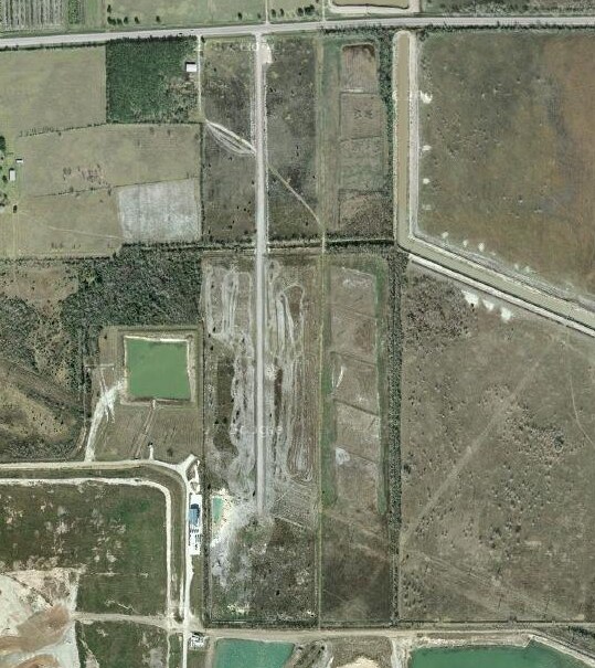
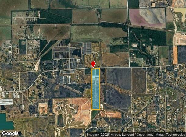
Property Record
4110 Fm 517 Rd E, Alvin, TX 77511
NEARBY LISTINGS FOR SALE OR LEASE
Property Detail
4110 Fm 517 Rd E
Houston-The Woodlands-Sugar Land, TX
600 Subd
4142-0000-0010-004
ABST 600 I & G N RR SUR SEC 12 LOTS 10,12,31,34,53 & 55 (10-4) I & G N RR SUR SUB
Commercialnec
Galveston
X
Texas
48039C0170K
10,12
2024
58.93 AC
2025
Southeast Outlier
723401
Houston
99,200 SF
DEMOGRAPHICS near 4110 Fm 517 Rd E
1 Mile
3 Mile
5 Mile
2024 Total Population
97
6,176
77,859
2029 Population
103
6,571
83,017
Pop Growth 2024-2029
+ 6.19%
+ 6.40%
+ 6.62%
Average Age
41
39
37
2024 Total Households
35
2,109
26,460
HH Growth 2024-2029
+ 5.71%
+ 6.73%
+ 7.09%
Median Household Inc
$112,500
$100,048
$96,340
Avg Household Size
2.70
2.90
2.90
2024 Avg HH Vehicles
3.00
2.00
2.00
Median Home Value
$355,555
$290,927
$277,149
Median Year Built
1993
2003
1996
Nearby Places
Map Layers
Map Styles
 Street
 Aerial
- Restaurants
- Banks
- Shops
- Fitness
- Groceries
PUBLIC TRANSPORTATION
AIRPORT
William P Hobby
DRIVE
WALK
Distance
William P Hobby
34 min
18.7 mi
Freight Ports
Port of Houston
DRIVE
WALK
Distance
Port of Houston
45 min
26.9 mi
Nearby Properties
Address
Land Use
TOTAL SIZE
Lot Size
Zoning
Address
Land Use
TOTAL SIZE
Lot Size
Zoning
13.56 AC
Address
Land Use
TOTAL SIZE
Lot Size
Zoning
Address
Land Use
TOTAL SIZE
Lot Size
Zoning
197,506 SF
20.52 AC
Address
Land Use
TOTAL SIZE
Lot Size
Zoning
209,431 SF
17.44 AC
Address
Land Use
TOTAL SIZE
Lot Size
Zoning
46,543 SF
30.89 AC
Address
Land Use
TOTAL SIZE
Lot Size
Zoning
110,165 SF
12.32 AC
Address
Land Use
TOTAL SIZE
Lot Size
Zoning
276,750 SF
35.24 AC
Address
Land Use
TOTAL SIZE
Lot Size
Zoning
74,406 SF
11.99 AC
Address
Land Use
TOTAL SIZE
Lot Size
Zoning
10,160 SF
1.57 AC
Address
Land Use
TOTAL SIZE
Lot Size
Zoning
22,400 SF
2.25 AC
0067
Address
Land Use
TOTAL SIZE
Lot Size
Zoning
16,620 SF
1.59 AC
Address
Land Use
TOTAL SIZE
Lot Size
Zoning
40,484 SF
1.96 AC
Address
Land Use
TOTAL SIZE
Lot Size
Zoning
25,352 SF
2.29 AC
Address
Land Use
TOTAL SIZE
Lot Size
Zoning
94,809 SF
49.01 AC
0103
Address
Land Use
TOTAL SIZE
Lot Size
Zoning
34,152 SF
1.39 AC
Address
Land Use
TOTAL SIZE
Lot Size
Zoning
49,392 SF
5.44 AC
Address
Land Use
TOTAL SIZE
Lot Size
Zoning
32,452 SF
5.46 AC
0086
Address
Land Use
TOTAL SIZE
Lot Size
Zoning
64,346 SF
5.73 AC
Address
Land Use
TOTAL SIZE
Lot Size
Zoning
11,000 SF
8.92 AC
0071
Address
Land Use
TOTAL SIZE
Lot Size
Zoning
15,025 SF
5.92 AC
0024
Address
Land Use
TOTAL SIZE
Lot Size
Zoning
249.43 AC
Address
Land Use
TOTAL SIZE
Lot Size
Zoning
72,000 SF
5.35 AC
Address
Land Use
TOTAL SIZE
Lot Size
Zoning
7,993 SF
1.38 AC
Address
Land Use
TOTAL SIZE
Lot Size
Zoning
10,547 SF
1.82 AC
Address
Land Use
TOTAL SIZE
Lot Size
Zoning
4,559 SF
0.92 AC
Address
Land Use
TOTAL SIZE
Lot Size
Zoning
28,000 SF
7.39 AC
0029
Address
Land Use
TOTAL SIZE
Lot Size
Zoning
29,590 SF
4.51 AC
0139
Address
Land Use
TOTAL SIZE
Lot Size
Zoning
846 SF
25.34 AC
SFR
The World's #1 Commercial Real Estate Marketplace
Connect with us
© 2025 CoStar Group
The information above has been obtained from sources believed reliable. While we do not doubt its accuracy we have not verified it and make no guarantee, warranty or representation about it. It is your responsibility to independently confirm its accuracy and completeness. Any projections, opinions, assumptions, or estimates used are for example only and do not represent the current or future performance of the property. The value of this transaction to you depends on tax and other factors which should be evaluated by your tax, financial, and legal advisors. You and your advisors should conduct a careful, independent investigation of the property to determine to your satisfaction the suitability of the property for your needs.