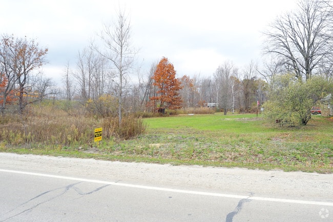
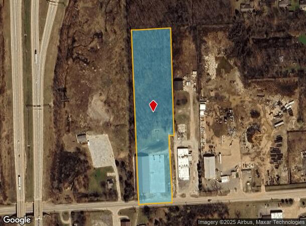
Property Record
4110 Griswold Rd, Port Huron, MI 48060
NEARBY LISTINGS FOR SALE OR LEASE
Property Detail
4110 Griswold Rd
28-007-3014-001
W 5 A OF S 30 A OF SE 1/4 OF SE 1/4 ALSO 1 ROD ADJ ON E. EXC E 30' OF S 382.31' SECTION 7 T6N R17E 5.11 A
Loftbuilding
St. Clair
X
Michigan
26147C0355D
5.11 AC
2025
St Clair & Lapeer Counties
2025
Detroit
636000
Detroit-Warren-Dearborn, MI
14,896 SF
DEMOGRAPHICS near 4110 Griswold Rd
1 mile
3 mile
5 mile
2024 Total Population
767
32,398
66,451
2029 Population
752
32,283
66,331
Pop Growth 2024-2029
(1.96%)
(0.35%)
(0.18%)
Average Age
41
40
41
2024 Total Households
321
12,579
27,283
HH Growth 2024-2029
(2.18%)
(0.49%)
(0.26%)
Median Household Inc
$36,447
$49,648
$54,789
Avg Household Size
2.30
2.40
2.30
2024 Avg HH Vehicles
2.00
2.00
2.00
Median Home Value
$120,161
$134,307
$156,895
Median Year Built
1969
1968
1970
Nearby Places
Map Layers
Map Styles
 Street
 Aerial
Transit
 Traffic
 Biking
Places
Listings with unknown addresses are not visible on the map
- Restaurants
- Banks
- Shops
- Fitness
- Groceries
PUBLIC TRANSPORTATION
COMMUTER RAIL
Port Huron Amtrak Station (Blue Water - Amtrak)
Drive
Walk
Distance
Port Huron Amtrak Station (Blue Water - Amtrak)
8 min
2.7 mi
Freight Ports
Port of Toledo
Drive
Walk
Distance
Port of Toledo
143 min
118.1 mi
SALE & LEASE HISTORY
LISTING DATE
SALE/LEASE

Nov 17, 2017
For Sale
Nearby Properties
Address
Land Use
TOTAL SIZE
Lot Size
Zoning
Address
Land Use
TOTAL SIZE
Lot Size
Zoning
206,565 SF
22.08 AC
I
Address
Land Use
TOTAL SIZE
Lot Size
Zoning
241,664 SF
50.15 AC
B-3
Address
Land Use
TOTAL SIZE
Lot Size
Zoning
Address
Land Use
TOTAL SIZE
Lot Size
Zoning
134,379 SF
15 AC
RM-2
Address
Land Use
TOTAL SIZE
Lot Size
Zoning
115,172 SF
11.29 AC
A1
Address
Land Use
TOTAL SIZE
Lot Size
Zoning
173,584 SF
9.50 AC
M1
Address
Land Use
TOTAL SIZE
Lot Size
Zoning
1,090 SF
7.77 AC
A1
Address
Land Use
TOTAL SIZE
Lot Size
Zoning
149,732 SF
12.48 AC
M1
Address
Land Use
TOTAL SIZE
Lot Size
Zoning
109,097 SF
6.47 AC
A2
Address
Land Use
TOTAL SIZE
Lot Size
Zoning
137,720 SF
12.04 AC
B-3
Address
Land Use
TOTAL SIZE
Lot Size
Zoning
94,537 SF
12.63 AC
B-3
Address
Land Use
TOTAL SIZE
Lot Size
Zoning
39,747 SF
3.11 AC
R-2 RES
Address
Land Use
TOTAL SIZE
Lot Size
Zoning
112,566 SF
7.20 AC
B-3
Address
Land Use
TOTAL SIZE
Lot Size
Zoning
77,868 SF
8.91 AC
RM-2
Address
Land Use
TOTAL SIZE
Lot Size
Zoning
1,657 SF
94.24 AC
MIXED
Address
Land Use
TOTAL SIZE
Lot Size
Zoning
73,882 SF
6.50 AC
B-3
Address
Land Use
TOTAL SIZE
Lot Size
Zoning
39,547 SF
A1
Address
Land Use
TOTAL SIZE
Lot Size
Zoning
140,230 SF
7.90 AC
M1
Address
Land Use
TOTAL SIZE
Lot Size
Zoning
333,076 SF
23.19 AC
M2
Address
Land Use
TOTAL SIZE
Lot Size
Zoning
85,200 SF
4.23 AC
M1
Address
Land Use
TOTAL SIZE
Lot Size
Zoning
45,750 SF
M1
Address
Land Use
TOTAL SIZE
Lot Size
Zoning
26,962 SF
3.03 AC
C1
Address
Land Use
TOTAL SIZE
Lot Size
Zoning
198,647 SF
26.04 AC
B-3
Address
Land Use
TOTAL SIZE
Lot Size
Zoning
168,310 SF
8.90 AC
M1
Address
Land Use
TOTAL SIZE
Lot Size
Zoning
118,606 SF
9.15 AC
A1
Address
Land Use
TOTAL SIZE
Lot Size
Zoning
105,269 SF
6 AC
M1
Address
Land Use
TOTAL SIZE
Lot Size
Zoning
81,940 SF
3.50 AC
M1
Address
Land Use
TOTAL SIZE
Lot Size
Zoning
86,480 SF
4.40 AC
M1
Address
Land Use
TOTAL SIZE
Lot Size
Zoning
49,695 SF
9.30 AC
MD
Address
Land Use
TOTAL SIZE
Lot Size
Zoning
70,020 SF
7.15 AC
M1
The World's #1 Commercial Real Estate Marketplace
Connect with us
© 2026 CoStar Group
The information above has been obtained from sources believed reliable. While we do not doubt its accuracy we have not verified it and make no guarantee, warranty or representation about it. It is your responsibility to independently confirm its accuracy and completeness. Any projections, opinions, assumptions, or estimates used are for example only and do not represent the current or future performance of the property. The value of this transaction to you depends on tax and other factors which should be evaluated by your tax, financial, and legal advisors. You and your advisors should conduct a careful, independent investigation of the property to determine to your satisfaction the suitability of the property for your needs.