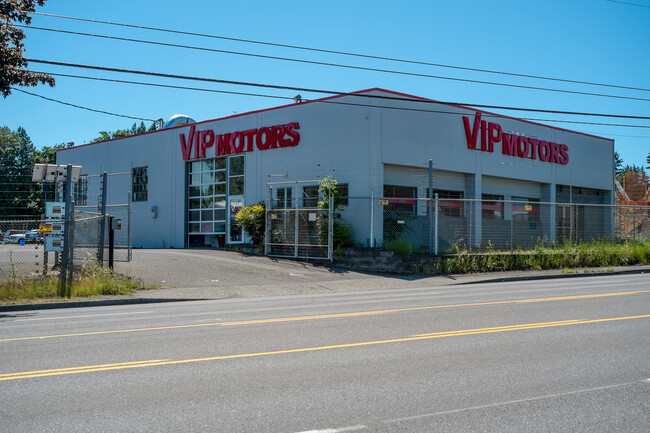
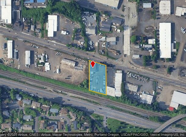
Property Record
4110 Ne Columbia Blvd, Portland, OR 97211

NEARBY LISTINGS FOR SALE OR LEASE
Property Detail
4110 Ne Columbia Blvd
R315322
SECTION 13 1N 1E, TL 3300 0.93 ACRES
Industrialgeneral
Multnomah
ARE
Oregon
53011C0525D
0.93 AC
2025
Gateway
2025
Portland
007300
Portland-Vancouver-Hillsboro, OR-WA
4,800 SF
DEMOGRAPHICS near 4110 Ne Columbia Blvd
1 Mile
3 Mile
5 Mile
2024 Total Population
10,794
116,552
370,139
2029 Population
10,490
114,048
370,036
Pop Growth 2024-2029
(2.82%)
(2.15%)
(0.03%)
Average Age
40
40
40
2024 Total Households
4,140
49,475
170,912
HH Growth 2024-2029
(3.26%)
(2.38%)
(0.08%)
Median Household Inc
$98,863
$94,810
$78,831
Avg Household Size
2.40
2.20
2.00
2024 Avg HH Vehicles
2.00
2.00
1.00
Median Home Value
$624,026
$639,244
$570,397
Median Year Built
1948
1948
1962
Nearby Places
Map Layers
Map Styles
 Street
 Aerial
- Restaurants
- Banks
- Shops
- Fitness
- Groceries
PUBLIC TRANSPORTATION
COMMUTER RAIL
DRIVE
WALK
Distance
15 min
6.9 mi
DRIVE
WALK
Distance
16 min
7.4 mi
AIRPORT
Portland International
DRIVE
WALK
Distance
Portland International
11 min
4.4 mi
Freight Ports
Port of Portland
DRIVE
WALK
Distance
Port of Portland
16 min
7.7 mi
SALE & LEASE HISTORY
LISTING DATE
SALE/LEASE

Nov 28, 2016
For Lease
Jul 07, 2020
For Sale
Dec 01, 2020
For Lease
Nearby Properties
Address
Land Use
TOTAL SIZE
Lot Size
Zoning
Address
Land Use
TOTAL SIZE
Lot Size
Zoning
1,405,000 SF
16.51 AC
IG2
Address
Land Use
TOTAL SIZE
Lot Size
Zoning
15,473 SF
192.67 AC
IG2
Address
Land Use
TOTAL SIZE
Lot Size
Zoning
178,785 SF
10.20 AC
R5
Address
Land Use
TOTAL SIZE
Lot Size
Zoning
817,845 SF
22.54 AC
IG2
Address
Land Use
TOTAL SIZE
Lot Size
Zoning
296,039 SF
11.70 AC
R5
Address
Land Use
TOTAL SIZE
Lot Size
Zoning
Address
Land Use
TOTAL SIZE
Lot Size
Zoning
134,398 SF
3.17 AC
CG
Address
Land Use
TOTAL SIZE
Lot Size
Zoning
23.95 AC
IG2
Address
Land Use
TOTAL SIZE
Lot Size
Zoning
126.43 AC
IG2
Address
Land Use
TOTAL SIZE
Lot Size
Zoning
1,660,710 SF
110.33 AC
IG2
Address
Land Use
TOTAL SIZE
Lot Size
Zoning
126.40 AC
IG2
Address
Land Use
TOTAL SIZE
Lot Size
Zoning
105.72 AC
IG2
Address
Land Use
TOTAL SIZE
Lot Size
Zoning
85,000 SF
1.65 AC
CI2
Address
Land Use
TOTAL SIZE
Lot Size
Zoning
97,000 SF
NULL
Address
Land Use
TOTAL SIZE
Lot Size
Zoning
107,958 SF
2.48 AC
IG2
Address
Land Use
TOTAL SIZE
Lot Size
Zoning
40,595 SF
1.99 AC
IRD
Address
Land Use
TOTAL SIZE
Lot Size
Zoning
11,375 SF
1.46 AC
CI2
Address
Land Use
TOTAL SIZE
Lot Size
Zoning
133.11 AC
IG2
Address
Land Use
TOTAL SIZE
Lot Size
Zoning
64,673 SF
NULL
Address
Land Use
TOTAL SIZE
Lot Size
Zoning
1,256 SF
103.58 AC
IG2
Address
Land Use
TOTAL SIZE
Lot Size
Zoning
47.70 AC
IG2
Address
Land Use
TOTAL SIZE
Lot Size
Zoning
258,082 SF
2.80 AC
CS
Address
Land Use
TOTAL SIZE
Lot Size
Zoning
257,560 SF
NULL
Address
Land Use
TOTAL SIZE
Lot Size
Zoning
112,578 SF
2.94 AC
CI2
Address
Land Use
TOTAL SIZE
Lot Size
Zoning
118,469 SF
47.45 AC
IG2
Address
Land Use
TOTAL SIZE
Lot Size
Zoning
62,100 SF
4.50 AC
OS
Address
Land Use
TOTAL SIZE
Lot Size
Zoning
205,034 SF
0.38 AC
RM1
Address
Land Use
TOTAL SIZE
Lot Size
Zoning
263,159 SF
2.07 AC
CM3
Address
Land Use
TOTAL SIZE
Lot Size
Zoning
141,560 SF
8.12 AC
R5
Address
Land Use
TOTAL SIZE
Lot Size
Zoning
361,241 SF
1.80 AC
CI2
The World's #1 Commercial Real Estate Marketplace
Connect with us
© 2026 CoStar Group
The information above has been obtained from sources believed reliable. While we do not doubt its accuracy we have not verified it and make no guarantee, warranty or representation about it. It is your responsibility to independently confirm its accuracy and completeness. Any projections, opinions, assumptions, or estimates used are for example only and do not represent the current or future performance of the property. The value of this transaction to you depends on tax and other factors which should be evaluated by your tax, financial, and legal advisors. You and your advisors should conduct a careful, independent investigation of the property to determine to your satisfaction the suitability of the property for your needs.