Property Record
4110 W Superior St, Duluth, MN 55807


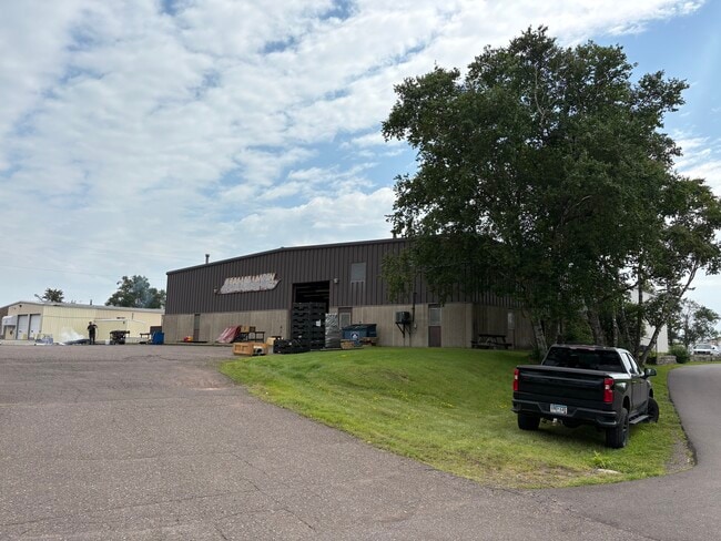
This Property Is For Sale
Current Lease Availabilities
NEARBY LISTINGS FOR SALE OR LEASE
Property Detail
4110 W Superior St
Duluth, MN-WI
Oneota Industrial Park
010359800350
THAT PART OF LOT 6 BLOCK 3 LYING NELY AND ELYOF THE LINE DESCRIBED AS FOLLOWS: COMMENCINGAT THE MOST ELY CORNER OF LOT 6 BLK 3; THENCEON AN ASSUMED BEARING OF S43DEG47'51"W ALONGTHE SELY LINE OF LOT 6 BLK 3 A DISTANCE OF184.58 FT TO THE INTERSECTION
Commercialnec
St Louis
X
Minnesota
27137C3857E
6
2025
1.50 AC
2024
West End
015800
Duluth
8,300 SF
DEMOGRAPHICS near 4110 W Superior St
1 Mile
3 Mile
5 Mile
2024 Total Population
4,782
26,696
72,010
2029 Population
4,685
26,202
71,000
Pop Growth 2024-2029
(2.03%)
(1.85%)
(1.40%)
Average Age
40
40
40
2024 Total Households
2,222
11,971
32,293
HH Growth 2024-2029
(2.12%)
(2.00%)
(1.49%)
Median Household Inc
$50,539
$52,531
$51,386
Avg Household Size
2.10
2.10
2.10
2024 Avg HH Vehicles
2.00
2.00
2.00
Median Home Value
$142,224
$162,532
$174,511
Median Year Built
1946
1948
1954
Nearby Places
Map Layers
Map Styles
 Street
 Aerial
- Restaurants
- Banks
- Shops
- Fitness
- Groceries
PUBLIC TRANSPORTATION
AIRPORT
Duluth International
DRIVE
WALK
Distance
Duluth International
21 min
9.4 mi
Freight Ports
Port Milwaukee
DRIVE
WALK
Distance
Port Milwaukee
452 min
398.9 mi
Nearby Properties
Address
Land Use
TOTAL SIZE
Lot Size
Zoning
Address
Land Use
TOTAL SIZE
Lot Size
Zoning
328,704 SF
3.81 AC
Address
Land Use
TOTAL SIZE
Lot Size
Zoning
391,335 SF
53.53 AC
Address
Land Use
TOTAL SIZE
Lot Size
Zoning
175 AC
W1
Address
Land Use
TOTAL SIZE
Lot Size
Zoning
195,455 SF
54.06 AC
Address
Land Use
TOTAL SIZE
Lot Size
Zoning
93,584 SF
0.66 AC
Address
Land Use
TOTAL SIZE
Lot Size
Zoning
87,768 SF
2.42 AC
Address
Land Use
TOTAL SIZE
Lot Size
Zoning
107,796 SF
9.19 AC
Address
Land Use
TOTAL SIZE
Lot Size
Zoning
62,634 SF
4.32 AC
Address
Land Use
TOTAL SIZE
Lot Size
Zoning
68,296 SF
0.38 AC
Address
Land Use
TOTAL SIZE
Lot Size
Zoning
72,980 SF
2.85 AC
R1B
Address
Land Use
TOTAL SIZE
Lot Size
Zoning
1,200 SF
10.74 AC
Address
Land Use
TOTAL SIZE
Lot Size
Zoning
5,392 SF
24.92 AC
Address
Land Use
TOTAL SIZE
Lot Size
Zoning
8.50 AC
W1
Address
Land Use
TOTAL SIZE
Lot Size
Zoning
28.37 AC
W1
Address
Land Use
TOTAL SIZE
Lot Size
Zoning
71,967 SF
0.16 AC
Address
Land Use
TOTAL SIZE
Lot Size
Zoning
24,389 SF
1.68 AC
Address
Land Use
TOTAL SIZE
Lot Size
Zoning
52.06 AC
M2
Address
Land Use
TOTAL SIZE
Lot Size
Zoning
85,370 SF
1.05 AC
Address
Land Use
TOTAL SIZE
Lot Size
Zoning
557,127 SF
37 AC
Address
Land Use
TOTAL SIZE
Lot Size
Zoning
185,313 SF
Address
Land Use
TOTAL SIZE
Lot Size
Zoning
73,973 SF
2.84 AC
Address
Land Use
TOTAL SIZE
Lot Size
Zoning
96,000 SF
1.35 AC
Address
Land Use
TOTAL SIZE
Lot Size
Zoning
169,373 SF
6.54 AC
Address
Land Use
TOTAL SIZE
Lot Size
Zoning
6.01 AC
M2
Address
Land Use
TOTAL SIZE
Lot Size
Zoning
20.01 AC
Address
Land Use
TOTAL SIZE
Lot Size
Zoning
1.63 AC
Address
Land Use
TOTAL SIZE
Lot Size
Zoning
17,638 SF
5.37 AC
Address
Land Use
TOTAL SIZE
Lot Size
Zoning
24,555 SF
1.14 AC
Address
Land Use
TOTAL SIZE
Lot Size
Zoning
62,138 SF
6.55 AC
The World's #1 Commercial Real Estate Marketplace
Connect with us
© 2025 CoStar Group
The information above has been obtained from sources believed reliable. While we do not doubt its accuracy we have not verified it and make no guarantee, warranty or representation about it. It is your responsibility to independently confirm its accuracy and completeness. Any projections, opinions, assumptions, or estimates used are for example only and do not represent the current or future performance of the property. The value of this transaction to you depends on tax and other factors which should be evaluated by your tax, financial, and legal advisors. You and your advisors should conduct a careful, independent investigation of the property to determine to your satisfaction the suitability of the property for your needs.