Property Record
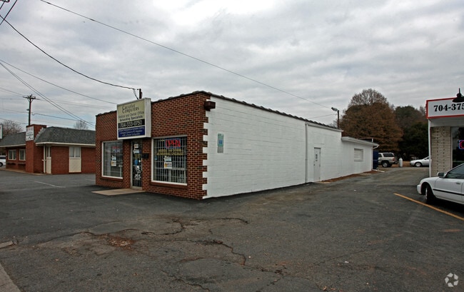
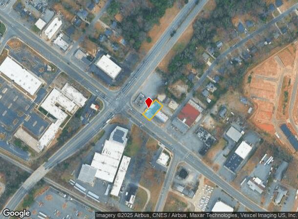
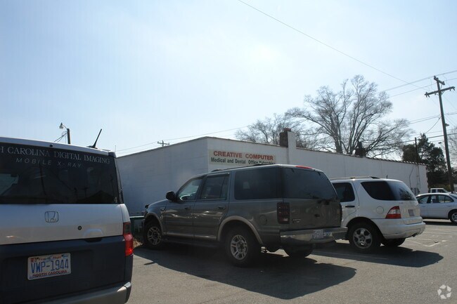
4111 Monroe Rd, Charlotte, NC 28205

NEARBY LISTINGS FOR SALE OR LEASE
Property Detail
4111 Monroe Rd
Charlotte-Concord-Gastonia, NC-SC
A Monroe Road Block
159-062-03
P1 & 2 BA M3-215
Commercialnec
Mecklenburg
X
North Carolina
3710456300K
3
2024
0.18 AC
2025
East
001802
Charlotte
1,493 SF
DEMOGRAPHICS near 4111 Monroe Rd
1 Mile
3 Mile
5 Mile
2024 Total Population
10,605
112,548
316,065
2029 Population
11,221
118,824
335,251
Pop Growth 2024-2029
+ 5.81%
+ 5.58%
+ 6.07%
Average Age
36
37
37
2024 Total Households
4,793
48,824
142,940
HH Growth 2024-2029
+ 5.74%
+ 5.67%
+ 6.29%
Median Household Inc
$50,294
$73,723
$71,343
Avg Household Size
2.10
2.20
2.10
2024 Avg HH Vehicles
1.00
2.00
2.00
Median Home Value
$370,383
$483,980
$403,529
Median Year Built
1968
1975
1985
Nearby Places
- Restaurants
- Banks
- Shops
- Fitness
- Groceries
PUBLIC TRANSPORTATION
COMMUTER RAIL
Charlotte Amtrak Station (Carolinian - Amtrak, Crescent - Amtrak, Piedmont - Amtrak)
DRIVE
WALK
Distance
Charlotte Amtrak Station (Carolinian - Amtrak, Crescent - Amtrak, Piedmont - Amtrak)
9 min
5.4 mi
AIRPORT
Charlotte/Douglas International
DRIVE
WALK
Distance
Charlotte/Douglas International
22 min
12.2 mi
Concord-Padgett Regional
DRIVE
WALK
Distance
Concord-Padgett Regional
26 min
16.7 mi
Freight Ports
North Charleston Terminal
DRIVE
WALK
Distance
North Charleston Terminal
234 min
202.0 mi
Nearby Properties
Address
Land Use
TOTAL SIZE
Lot Size
Zoning
Address
Land Use
TOTAL SIZE
Lot Size
Zoning
3,286,640 SF
55.70 AC
O6CD
Address
Land Use
TOTAL SIZE
Lot Size
Zoning
1,250,218 SF
17.75 AC
O2
Address
Land Use
TOTAL SIZE
Lot Size
Zoning
852,355 SF
16.72 AC
MUDDO
Address
Land Use
TOTAL SIZE
Lot Size
Zoning
1,017,564 SF
13.91 AC
O2
Address
Land Use
TOTAL SIZE
Lot Size
Zoning
864,694 SF
11.07 AC
MUDDO
Address
Land Use
TOTAL SIZE
Lot Size
Zoning
729,709 SF
10.67 AC
B2
Address
Land Use
TOTAL SIZE
Lot Size
Zoning
690,862 SF
136.80 AC
R17MF
Address
Land Use
TOTAL SIZE
Lot Size
Zoning
831,732 SF
24.50 AC
R3
Address
Land Use
TOTAL SIZE
Lot Size
Zoning
606,594 SF
3.45 AC
MUDDO
Address
Land Use
TOTAL SIZE
Lot Size
Zoning
534,085 SF
0.85 AC
MUDDO
Address
Land Use
TOTAL SIZE
Lot Size
Zoning
590,973 SF
6.59 AC
MUDDCD
Address
Land Use
TOTAL SIZE
Lot Size
Zoning
501,350 SF
6.82 AC
Address
Land Use
TOTAL SIZE
Lot Size
Zoning
586,989 SF
6.50 AC
Address
Land Use
TOTAL SIZE
Lot Size
Zoning
411,129 SF
2.44 AC
B2
Address
Land Use
TOTAL SIZE
Lot Size
Zoning
252,198 SF
174 SF
O-2
Address
Land Use
TOTAL SIZE
Lot Size
Zoning
335,338 SF
3.37 AC
B1
Address
Land Use
TOTAL SIZE
Lot Size
Zoning
437,989 SF
4.30 AC
B2
Address
Land Use
TOTAL SIZE
Lot Size
Zoning
465,729 SF
2.47 AC
Address
Land Use
TOTAL SIZE
Lot Size
Zoning
374,360 SF
9.89 AC
MUDDO
Address
Land Use
TOTAL SIZE
Lot Size
Zoning
347,636 SF
2.38 AC
B2
Address
Land Use
TOTAL SIZE
Lot Size
Zoning
473,942 SF
5.31 AC
O2
Address
Land Use
TOTAL SIZE
Lot Size
Zoning
287,182 SF
21.73 AC
CC
Address
Land Use
TOTAL SIZE
Lot Size
Zoning
470,859 SF
2.24 AC
B1
Address
Land Use
TOTAL SIZE
Lot Size
Zoning
450,292 SF
28.95 AC
R22MF
Address
Land Use
TOTAL SIZE
Lot Size
Zoning
217,094 SF
4.27 AC
MUDD-O
Address
Land Use
TOTAL SIZE
Lot Size
Zoning
344,226 SF
18.83 AC
B2
Address
Land Use
TOTAL SIZE
Lot Size
Zoning
234,540 SF
2.62 AC
R-22MF
Address
Land Use
TOTAL SIZE
Lot Size
Zoning
16,506 SF
14.98 AC
R22MF
Address
Land Use
TOTAL SIZE
Lot Size
Zoning
276,188 SF
1.95 AC
Address
Land Use
TOTAL SIZE
Lot Size
Zoning
237,587 SF
55 AC
O1
The World's #1 Commercial Real Estate Marketplace
Connect with us
© 2025 CoStar Group
The information above has been obtained from sources believed reliable. While we do not doubt its accuracy we have not verified it and make no guarantee, warranty or representation about it. It is your responsibility to independently confirm its accuracy and completeness. Any projections, opinions, assumptions, or estimates used are for example only and do not represent the current or future performance of the property. The value of this transaction to you depends on tax and other factors which should be evaluated by your tax, financial, and legal advisors. You and your advisors should conduct a careful, independent investigation of the property to determine to your satisfaction the suitability of the property for your needs.