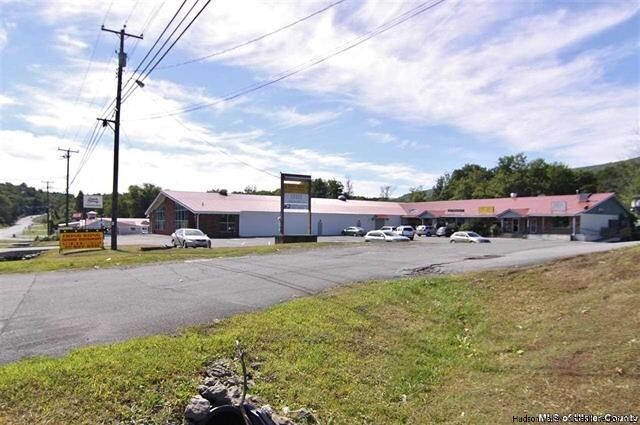
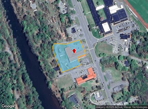
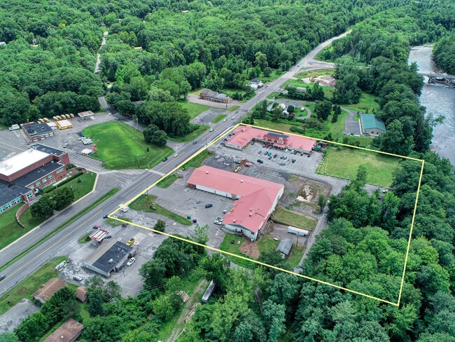
Property Record
4115 State Route 28, Boiceville, NY 12412
NEARBY LISTINGS FOR SALE OR LEASE
-
-
View all Boiceville listings for sale on LoopNet.com
Property Detail
4115 State Route 28
4000-036.011-0001-011.000-0000
Ulster
Communitycenter
New York
AE
11.000
36111C0245F
1.98 AC
2025
Hudson Valley Area
2024
Other Market Areas
951000
Kingston, NY
36,720 SF
DEMOGRAPHICS near 4115 State Route 28
1 Mile
3 Mile
5 Mile
2024 Total Population
511
1,767
4,096
2029 Population
511
1,762
4,082
Pop Growth 2024-2029
0.00%
(0.28%)
(0.34%)
Average Age
48
49
49
2024 Total Households
223
820
1,911
HH Growth 2024-2029
(0.45%)
(0.24%)
(0.37%)
Median Household Inc
$74,867
$74,018
$75,202
Avg Household Size
2.30
2.20
2.10
2024 Avg HH Vehicles
2.00
2.00
2.00
Median Home Value
$389,705
$343,119
$352,904
Median Year Built
1977
1969
1969
Nearby Places
- Restaurants
- Banks
- Shops
- Fitness
- Groceries
SALE & LEASE HISTORY
LISTING DATE
SALE/LEASE

Sep 23, 2016
For Sale
May 16, 2024
For Sale
May 15, 2019
For Sale
Nearby Properties
Address
Land Use
TOTAL SIZE
Lot Size
Zoning
Address
Land Use
TOTAL SIZE
Lot Size
Zoning
2.20 AC
02 - SINGL
Address
Land Use
TOTAL SIZE
Lot Size
Zoning
9,850 SF
0.16 AC
02 - SINGL
Address
Land Use
TOTAL SIZE
Lot Size
Zoning
3,183 SF
13.40 AC
03 - MULTI
Address
Land Use
TOTAL SIZE
Lot Size
Zoning
Address
Land Use
TOTAL SIZE
Lot Size
Zoning
822.26 AC
05 - COMME
Address
Land Use
TOTAL SIZE
Lot Size
Zoning
3,824 SF
8 AC
03 - MULTI
Address
Land Use
TOTAL SIZE
Lot Size
Zoning
37,684 SF
1.14 AC
02 - SINGL
Address
Land Use
TOTAL SIZE
Lot Size
Zoning
5,326 SF
3.40 AC
02 - SINGL
Address
Land Use
TOTAL SIZE
Lot Size
Zoning
1,540 SF
62.20 AC
03 - MULTI
Address
Land Use
TOTAL SIZE
Lot Size
Zoning
4,969 SF
3 AC
03 - MULTI
Address
Land Use
TOTAL SIZE
Lot Size
Zoning
2,960 SF
10.10 AC
03 - MULTI
Address
Land Use
TOTAL SIZE
Lot Size
Zoning
2,581 SF
15.90 AC
03 - MULTI
Address
Land Use
TOTAL SIZE
Lot Size
Zoning
2,073 SF
50.40 AC
R5
Address
Land Use
TOTAL SIZE
Lot Size
Zoning
3,816 SF
5 AC
R5
Address
Land Use
TOTAL SIZE
Lot Size
Zoning
2,195 SF
5 AC
03 - MULTI
Address
Land Use
TOTAL SIZE
Lot Size
Zoning
400 AC
03 - MULTI
Address
Land Use
TOTAL SIZE
Lot Size
Zoning
2,962 SF
5 AC
R5
Address
Land Use
TOTAL SIZE
Lot Size
Zoning
2,178 SF
4 AC
03 - MULTI
Address
Land Use
TOTAL SIZE
Lot Size
Zoning
2,052 SF
5.60 AC
03 - MULTI
Address
Land Use
TOTAL SIZE
Lot Size
Zoning
2,924 SF
36.84 AC
R5
Address
Land Use
TOTAL SIZE
Lot Size
Zoning
1,104 SF
253.90 AC
03 - MULTI
Address
Land Use
TOTAL SIZE
Lot Size
Zoning
1,692 SF
39 AC
01 - NOT Z
Address
Land Use
TOTAL SIZE
Lot Size
Zoning
51.80 AC
03 - MULTI
Address
Land Use
TOTAL SIZE
Lot Size
Zoning
170.20 AC
R3
Address
Land Use
TOTAL SIZE
Lot Size
Zoning
2,204 SF
0.66 AC
03 - MULTI
Address
Land Use
TOTAL SIZE
Lot Size
Zoning
3,800 SF
1.10 AC
03 - MULTI
Address
Land Use
TOTAL SIZE
Lot Size
Zoning
2,509 SF
13.30 AC
03 - MULTI
Address
Land Use
TOTAL SIZE
Lot Size
Zoning
807.35 AC
NYS
Address
Land Use
TOTAL SIZE
Lot Size
Zoning
1,900 SF
15.20 AC
05 - COMME
The World's #1 Commercial Real Estate Marketplace
Connect with us
© 2025 CoStar Group
The information above has been obtained from sources believed reliable. While we do not doubt its accuracy we have not verified it and make no guarantee, warranty or representation about it. It is your responsibility to independently confirm its accuracy and completeness. Any projections, opinions, assumptions, or estimates used are for example only and do not represent the current or future performance of the property. The value of this transaction to you depends on tax and other factors which should be evaluated by your tax, financial, and legal advisors. You and your advisors should conduct a careful, independent investigation of the property to determine to your satisfaction the suitability of the property for your needs.