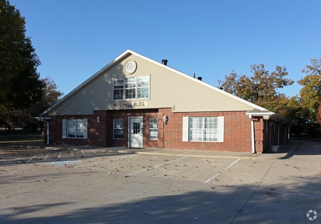
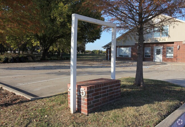
Property Record
4115 Dalrock Rd, Rowlett, TX 75088

Property Detail
4115 Dalrock Rd
Dallas-Fort Worth-Arlington, TX
MARIAN LT 2 ACS 0.461 INT201300130129 DD04262013 CO-DC 0143300000200 2CW01433000
44014330000020000
DALLAS
Commercialacreage
Texas
Z205
2
B and X Area of moderate flood hazard, usually the area between the limits of the 100-year and 500-year floods.
0.46 AC
0
Garland
2025
Dallas/Ft Worth
018134
NEARBY LISTINGS FOR SALE OR LEASE
DEMOGRAPHICS near 4115 Dalrock Rd
1 mile
3 mile
5 mile
2025 Total Population
11,030
50,583
143,435
2030 Population
12,059
54,850
157,660
Pop Growth 2025-2030
+ 9.33%
+ 8.44%
+ 9.92%
Average Age
40
40
40
2025 Total Households
3,748
18,643
50,834
HH Growth 2025-2030
+ 9.34%
+ 8.86%
+ 10.13%
Median Household Inc
$94,813
$97,533
$100,829
Avg Household Size
2.90
2.70
2.80
2025 Avg HH Vehicles
2.00
2.00
2.00
Median Home Value
$334,627
$366,644
$375,998
Median Year Built
1993
1994
1997
Nearby Places
Map Layers
Map Styles
 Street
 Aerial
Layers
 Traffic
 Biking
Places
Listings with unknown addresses are not visible on the map
- Restaurants
- Banks
- Shops
- Fitness
- Groceries
PUBLIC TRANSPORTATION
AIRPORT
Dallas Love Field
Drive
Walk
Distance
Dallas Love Field
38 min
24.5 mi
Dallas-Fort Worth International
Drive
Walk
Distance
Dallas-Fort Worth International
50 min
41.2 mi
Nearby Properties
Address
Land Use
TOTAL SIZE
Lot Size
Zoning
Address
Land Use
TOTAL SIZE
Lot Size
Zoning
559,567 SF
10.85 AC
Z80
Address
Land Use
TOTAL SIZE
Lot Size
Zoning
252,909 SF
11.73 AC
Address
Land Use
TOTAL SIZE
Lot Size
Zoning
283,096 SF
10.18 AC
Z80
Address
Land Use
TOTAL SIZE
Lot Size
Zoning
454,141 SF
4.86 AC
Address
Land Use
TOTAL SIZE
Lot Size
Zoning
260,782 SF
16.30 AC
Z77
Address
Land Use
TOTAL SIZE
Lot Size
Zoning
427,231 SF
9.96 AC
Z38
Address
Land Use
TOTAL SIZE
Lot Size
Zoning
313,217 SF
3.61 AC
Z205
Address
Land Use
TOTAL SIZE
Lot Size
Zoning
228,458 SF
5.56 AC
Z236
Address
Land Use
TOTAL SIZE
Lot Size
Zoning
282,628 SF
4.03 AC
Address
Land Use
TOTAL SIZE
Lot Size
Zoning
710,600 SF
3.91 AC
Z80
Address
Land Use
TOTAL SIZE
Lot Size
Zoning
178,125 SF
10.50 AC
Z77
Address
Land Use
TOTAL SIZE
Lot Size
Zoning
495,735 SF
2.92 AC
Z80
Address
Land Use
TOTAL SIZE
Lot Size
Zoning
138,183 SF
4.76 AC
Z80
Address
Land Use
TOTAL SIZE
Lot Size
Zoning
144,725 SF
12.89 AC
Address
Land Use
TOTAL SIZE
Lot Size
Zoning
227,296 SF
2.14 AC
Address
Land Use
TOTAL SIZE
Lot Size
Zoning
196,981 SF
8.92 AC
Address
Land Use
TOTAL SIZE
Lot Size
Zoning
43,600 SF
62.86 AC
Z306
Address
Land Use
TOTAL SIZE
Lot Size
Zoning
85,912 SF
5.93 AC
Address
Land Use
TOTAL SIZE
Lot Size
Zoning
420,500 SF
33.25 AC
Address
Land Use
TOTAL SIZE
Lot Size
Zoning
223,216 SF
13.79 AC
Z239
Address
Land Use
TOTAL SIZE
Lot Size
Zoning
261,000 SF
1 AC
Z318
Address
Land Use
TOTAL SIZE
Lot Size
Zoning
244,338 SF
4.44 AC
Address
Land Use
TOTAL SIZE
Lot Size
Zoning
271,051 SF
10.28 AC
Z01
Address
Land Use
TOTAL SIZE
Lot Size
Zoning
108,429 SF
2.06 AC
Address
Land Use
TOTAL SIZE
Lot Size
Zoning
99,800 SF
10.10 AC
C
Address
Land Use
TOTAL SIZE
Lot Size
Zoning
92,413 SF
4.98 AC
Z85
Address
Land Use
TOTAL SIZE
Lot Size
Zoning
151,893 SF
5.40 AC
Z308
Address
Land Use
TOTAL SIZE
Lot Size
Zoning
82,847 SF
4.87 AC
Z236
Address
Land Use
TOTAL SIZE
Lot Size
Zoning
78,017 SF
1.75 AC
Z236
Address
Land Use
TOTAL SIZE
Lot Size
Zoning
80,042 SF
6.42 AC
The World's #1 Commercial Real Estate Marketplace
Connect with us
© 2026 CoStar Group
The information above has been obtained from sources believed reliable. While we do not doubt its accuracy we have not verified it and make no guarantee, warranty or representation about it. It is your responsibility to independently confirm its accuracy and completeness. Any projections, opinions, assumptions, or estimates used are for example only and do not represent the current or future performance of the property. The value of this transaction to you depends on tax and other factors which should be evaluated by your tax, financial, and legal advisors. You and your advisors should conduct a careful, independent investigation of the property to determine to your satisfaction the suitability of the property for your needs.